Texas, Oklahoma, Kansas, Missouri and Arkansas Face Dual Threat of Severe Storms and Flash Flooding as Spring System Intensifies Tonight
SOUTHERN PLAINS TO MIDWEST — A developing spring weather system is set to bring both severe thunderstorms and a significant flash flooding threat from Texas through Oklahoma, Kansas, Missouri, and into parts of Arkansas through tonight.
Severe Storm Risk Expands From Texas to Missouri
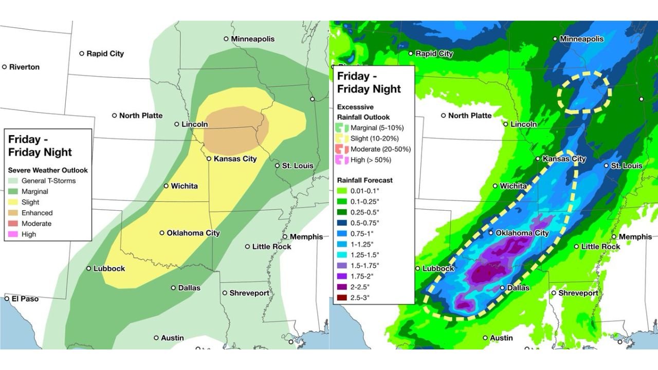
Forecast guidance shows a broad corridor of severe weather potential stretching from central Texas through Oklahoma and into Kansas and Missouri, with the highest concentration centered near cities like Dallas, Oklahoma City, Wichita, Kansas City, and extending toward St. Louis.
The risk level remains mostly in the slight to marginal categories, but a focused zone of stronger storms could develop, especially during the evening and overnight hours. These storms may produce gusty winds, isolated hail, and brief severe conditions, particularly across central Oklahoma and southern Kansas.
Heavy Rainfall Corridor Sets Up for Flash Flooding
Alongside the severe threat, a more impactful concern is emerging — a concentrated band of heavy rainfall capable of producing flash flooding.
Data indicates a well-defined corridor of 1 to 3 inches of rain, with isolated higher totals, extending from north Texas through Oklahoma and into Missouri. Areas around Dallas, Oklahoma City, and into parts of Kansas City sit within this heavier rainfall zone.
This setup increases the risk of flash flooding in urban areas, low-lying regions, and locations where storms repeatedly move over the same areas. The alignment of storms along this corridor suggests that rainfall could become intense in short periods.
Storms Track Northeast Overnight
The system is expected to organize and move from southwest to northeast through the night, gradually shifting the focus of heavy rain and storms toward Missouri and parts of the Midwest by early morning.
As this progression continues, cities farther northeast, including areas near St. Louis, could experience steady rainfall and embedded thunderstorms, while southern areas begin to taper off.
Northern Midwest Sees Lighter Rain but Widespread Coverage
Further north into the upper Midwest, including areas near Minneapolis, rainfall is expected to be more widespread but generally lighter, with lower flooding risk compared to the southern corridor.
However, persistent rain bands may still lead to wet conditions and localized minor impacts, especially where rainfall lingers for several hours.
A Classic Spring Setup With Two Key Threats
This system highlights a typical spring pattern where severe weather and heavy rainfall occur simultaneously, but not always with equal intensity in the same locations.
While severe storms remain scattered and somewhat limited, the flash flooding threat stands out as the primary concern, especially across the southern Plains into the mid-Mississippi Valley.
Residents across Texas, Oklahoma, Kansas, Missouri, and Arkansas should stay alert overnight, particularly in areas prone to flooding or where heavy rain develops quickly.
If you experience heavy rainfall, rising water, or strong storms in your area, share your updates with CabarrusWeekly.com to help keep others informed across the region.