Texas, Oklahoma, Kansas, Missouri and Iowa Under Rare Day 6 Severe Risk With Tornadoes, Large Hail and Damaging Winds Possible
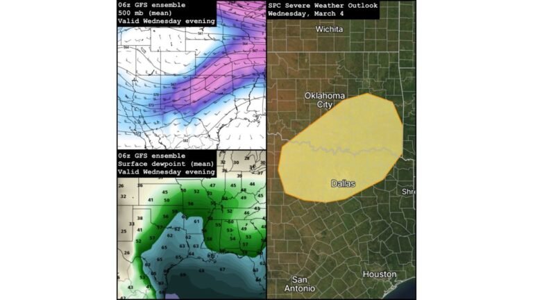
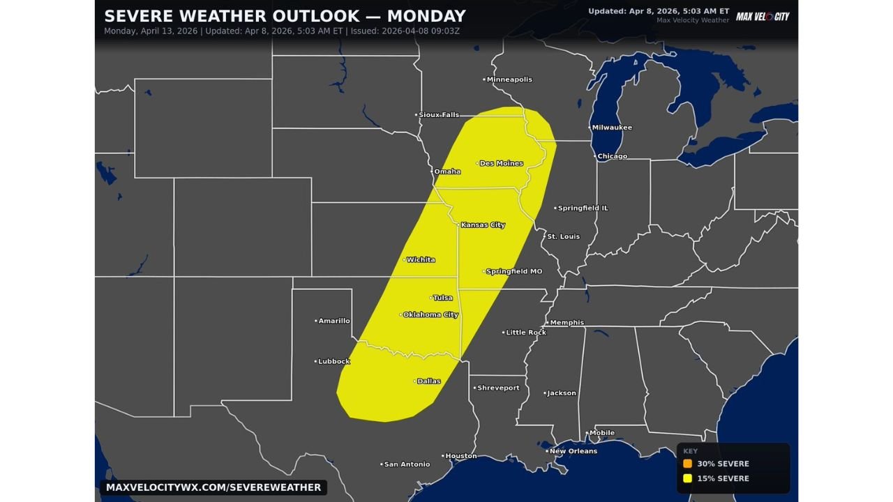
UNITED STATES — A rare extended-range severe weather outlook is raising concern across the central United States, as a Day 6 Slight Risk has been issued for Monday, April 13, covering a broad corridor from Texas through Oklahoma, Kansas, Missouri, and into Iowa.
This type of outlook so far in advance is uncommon and signals that confidence is growing in a potentially active severe weather setup early next week.
Cities in the Risk Zone Already Identified
Major population centers already highlighted within this risk area include:
- Dallas, Texas
- Oklahoma City, Oklahoma
- Wichita, Kansas
- Kansas City, Missouri
- Springfield, Missouri
- Des Moines, Iowa
Residents across these regions are being urged to begin reviewing severe weather safety plans now, as early signals point to a potentially impactful day.
Why This Early Risk Is Significant
A Day 6 Slight Risk is not issued frequently. When it is, it typically means:
- Forecast models are showing consistent signals of instability and storm development
- There is growing confidence in organized severe weather potential several days in advance
- The setup could support multiple types of hazards
This is also just one of several severe weather outlooks issued for Days 4 through 8, suggesting a prolonged active pattern rather than a single isolated event.
Primary Threats Expected
Based on the current setup, the following hazards are possible across the risk area:
- Very large hail from strong supercell thunderstorms
- Damaging wind gusts capable of causing widespread impacts
- Tornadoes, particularly if storms become well-organized
The combination of these threats indicates a classic Plains severe weather setup, where multiple hazards can occur simultaneously.
Atmospheric Setup Favoring Severe Storms
The developing pattern shows:
- Increasing moisture streaming northward from the Gulf of Mexico
- A strengthening jet stream providing wind shear
- A developing system moving out of the western United States
This combination creates an environment where thunderstorms can rapidly intensify and organize, especially across the Plains and Midwest.
Part of a Larger Multi Day Severe Weather Pattern
This Day 6 outlook is not happening in isolation. It is part of a broader trend showing:
- Multiple days of severe weather potential across the central U.S.
- A shifting corridor of storms moving from the southern Plains into the Midwest
- Increasing chances for repeated impacts in some areas
This reinforces the idea that early next week could be particularly active across a large portion of the country.
Cabarrus Weekly Perspective
When a severe weather risk is outlined this clearly nearly a week in advance, it is a signal that the atmosphere may be lining up for something more organized than usual.
For residents in Texas, Oklahoma, Kansas, Missouri, and Iowa, now is the time to:
- Review emergency plans
- Stay updated on forecast changes
- Prepare for the possibility of severe storms on Monday, April 13
While details will continue to evolve, the early warning signs are already in place for a potentially impactful start to next week across the central United States.