Texas to Gulf Coast Severe Weather Rebounds This Weekend After Below-Average Season, Southwest Texas Starts Friday
UNITED STATES — After a quieter-than-normal cold-season severe weather stretch across much of the Mid-South and Gulf Coast, a renewed threat is emerging that could bring the region closer to seasonal averages this weekend.
Over the past 90 days, severe weather activity has been below typical levels in areas that traditionally see winter storms, particularly across the Southeast and Gulf Coast. However, that pattern may be shifting.
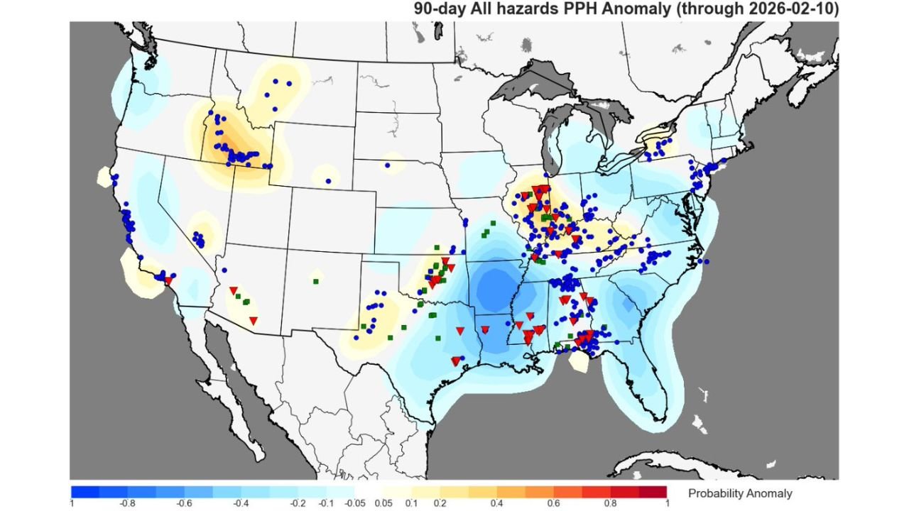
90-Day Severe Weather Trends Show Regional Differences
Recent 90-day hazard anomaly data shows near to above-average severe reports across portions of the Midwest, Plains, and even parts of the Northwest.
Meanwhile, the Mid-South, Central Gulf Coast, and Southeast have experienced below-average severe weather during the November through early February window.
Blue-shaded areas across parts of Louisiana, Mississippi, Alabama, and the Florida Panhandle indicate suppressed severe probabilities compared to climatology.
Southwest Texas Storms Begin the Sequence Friday
The next potential uptick in activity begins in Southwest Texas on Friday, where initial storm development could mark the start of a broader severe weather sequence.
As the system progresses eastward, conditions may become more favorable for organized storms across parts of Texas before expanding toward the Gulf Coast over the weekend.
Central Gulf Coast Near Average by Weekend
By Saturday and Sunday, parts of the Central Gulf Coast region could trend back toward near-average severe weather levels for this time of year.
States that may be involved include:
• Southern and eastern Texas
• Louisiana
• Mississippi
• Alabama
The potential for severe thunderstorms will depend on instability recovery, wind shear alignment, and storm timing.
Mid-South and Southeast Still Lagging Seasonally
Despite this weekend’s potential rebound, much of the broader Southeast remains below normal for cold-season severe activity compared to long-term averages.
That said, late winter often brings volatility in patterns, and even one active weekend can quickly shift short-term anomaly trends.
Bottom Line
After a relatively subdued severe weather season across the Mid-South and Gulf Coast, a developing system beginning in Southwest Texas on Friday could bring storms back into the picture. By the weekend, portions of the Central Gulf Coast may approach near-average severe levels.
Residents across Texas and the Gulf Coast should monitor forecast updates as details regarding storm intensity and coverage become clearer.
If severe weather develops in your area, share your reports and conditions with us at CabarrusWeekly.com.