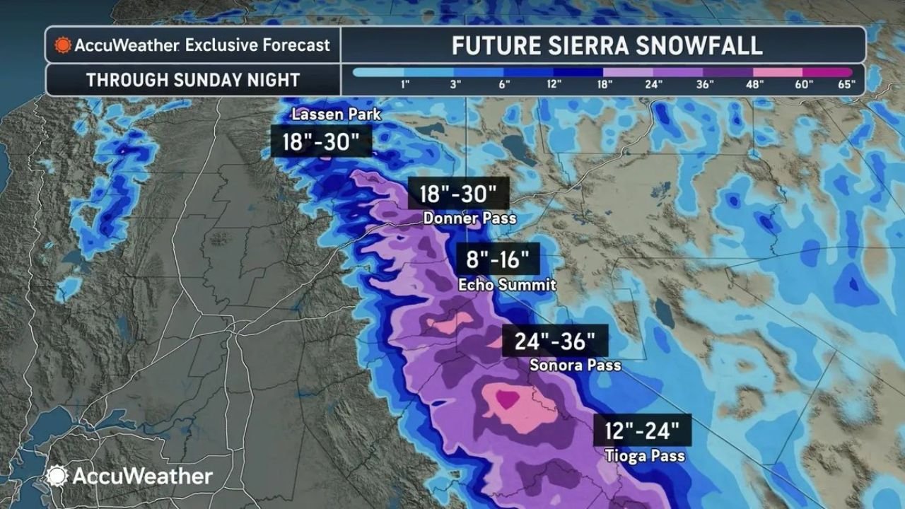
This Weekend: 3 To 5 Feet Of Snow Burying California Sierra Nevada Mountains Through Sunday Night With Up To 36 Inches At Sonora Pass And 30 Inches At Donner Pass And Lassen Park
CALIFORNIA — A powerful winter storm is delivering an extraordinary late-season snowfall event across the California Sierra Nevada mountains this weekend, with 3 to 5 feet of snow expected to pile up through Sunday night. The AccuWeather Exclusive Forecast highlights a dangerous and impressive snowfall accumulation event across multiple major mountain passes, with some locations set to receive their heaviest snowfall totals of the season.
Location By Location Snowfall Forecast Through Sunday Night
AccuWeather’s Future Sierra Snowfall forecast through Sunday night breaks down expected accumulations at key mountain locations:
- Sonora Pass — 24″ to 36″ — the highest forecast snowfall total in the outlook, with up to 3 full feet of snow expected at this elevation
- Donner Pass — 18″ to 30″ — a massive accumulation that will significantly impact one of California’s most traveled mountain corridors
- Lassen Park — 18″ to 30″ — matching Donner Pass for one of the higher snowfall totals across the northern Sierra, with up to 2.5 feet possible
- Tioga Pass — 12″ to 24″ — up to 2 feet of snow forecast at this iconic Yosemite-area pass
- Echo Summit — 8″ to 16″ — still a significant accumulation of up to a foot and a half at this South Lake Tahoe area location
What This Means For Travel And Safety
With 3 to 5 feet of snow accumulating across the Sierra Nevada through Sunday night, the impacts on travel and safety across California’s mountain corridors will be severe. Key concerns include:
- Major travel disruptions across all Sierra Nevada mountain passes through the weekend and into Monday
- Chain controls and road closures highly likely across Highway 50, Interstate 80, Highway 88, and other key Sierra crossings
- Whiteout conditions and near-zero visibility possible at the higher elevations during the heaviest snowfall periods
- Avalanche danger will increase significantly across backcountry areas as heavy snow loads build rapidly on mountain slopes
- Stranded motorists risk for anyone attempting to cross Sierra passes without proper equipment and preparation
A Remarkable Late-Season Snow Event
This snowfall event is notable not just for its intensity but for its timing. A 3 to 5 foot snowfall accumulation in mid-April represents a significant late-season winter storm for the Sierra Nevada — the kind of event that can dramatically boost the Sierra snowpack heading into the late spring and summer melt season, providing critical water resources for California.
Who Should Avoid The Sierra This Weekend
Anyone with plans to travel through or recreate in the Sierra Nevada this weekend should seriously reconsider or postpone those plans until conditions improve after Sunday night. This includes:
- Drivers using I-80, Highway 50, and other trans-Sierra routes — expect major delays, chain requirements, and potential closures
- Skiers and snowboarders — while resorts may benefit from fresh snow, access roads will be extremely hazardous
- Hikers and backcountry users — avalanche danger and extreme winter conditions make backcountry travel life-threatening this weekend
- Anyone traveling to or from the Lake Tahoe region — allow significant extra time and carry chains
Stay with CabarrusWeekly.com for continued coverage of this major Sierra Nevada snowstorm as accumulations build through Sunday night across California’s mountain passes.