This Week’s Severe Weather Pattern a Generational and Unprecedented Outbreak of Consecutive Severe Weather Days Across the Midwest and Plains as 15% Wind and Hail Probability Covers Kansas, Missouri, Nebraska, and Oklahoma
UNITED STATES — Something genuinely historic is unfolding across the central United States this week. Meteorologists are describing the current severe weather pattern as a generational and unprecedented outbreak of consecutive severe weather days — a sequence of Slight Risk designations firing back to back across the Midwest and Plains that forecasters say they have simply never seen anything like before. The Storm Prediction Center has active severe weather outlooks in place simultaneously across two separate zones today, with a 15% wind and hail probability covering a corridor from Kansas and Nebraska through Missouri and Oklahoma — one of the more significant daytime severe weather probability signals issued this early in the spring season.
This is not a single storm event. This is a pattern — and it is one that was predicted by long-range forecast models nearly two weeks ago.
What Makes This Week Historic
The term generational is not used lightly in meteorology. It carries a specific meaning — an event or pattern that exceeds anything in recent memory and stands apart from the historical record in a meaningful way.
What forecasters are flagging this week is not one extreme storm or one catastrophic outbreak. It is something more unusual and in some ways more meteorologically remarkable — a relentless, day-after-day sequence of Slight Risk severe weather designations across the Midwest and Plains firing in rapid succession, covering an enormous geographic area, and affecting tens of millions of people across multiple states over the course of a single week.
Slight Risk designations — Level 2 of 5 on the SPC scale — are the designation that indicates scattered severe thunderstorms are likely across a defined area. Getting one or two Slight Risk days in a week across the Plains is routine. Getting what meteorologists are now calling an unprecedented and generational outbreak of consecutive Slight Risk days across the same broad region — with each day bringing its own distinct and organized severe weather setup — is something that stands apart from normal spring patterns.
The fact that long-range forecast models identified this pattern nearly two weeks in advance adds another layer of significance. The Climate Forecast System model painted a signal over the southern Plains two weeks ago that pointed directly toward this week’s active pattern — a lead time that, if acted upon for preparedness purposes, could mean the difference between communities being caught off guard and communities being ready when the storms arrived.
Today’s Active Severe Weather Zones — Tuesday March 31
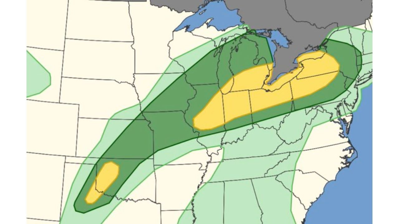
The SPC currently has two separate Slight Risk zones active across the United States today, reflecting the dual-zone nature of this historic pattern.
Northern Zone — Illinois, Indiana, Wisconsin, and Michigan
The larger northern Slight Risk zone covers a broad corridor across Illinois, Indiana, Wisconsin, and Michigan, with a Marginal Risk buffer extending through Iowa, Missouri, Ohio, and Kentucky. This is the primary Great Lakes and Ohio Valley threat zone today — where scattered severe thunderstorms with damaging winds and large hail are the primary concerns through the afternoon and evening.
Southern Zone — Kansas, Oklahoma, and Nebraska
The southern Slight Risk zone is centered over Kansas, Oklahoma, and the Nebraska border area — where isolated severe storms capable of large hail and damaging gusts are developing along the dryline through the afternoon. This zone is the preview of the much more significant southern Plains severe weather setups forecast for Wednesday and Friday.
The 15% Wind and Hail Probability — What It Means
Separate from the categorical Slight Risk designation, the SPC has issued a 15% probability for damaging winds and large hail across a corridor covering Kansas, Missouri, Nebraska, and Oklahoma. A 5% probability zone surrounds this core area across the broader central United States.
A 15% wind and hail probability is a meaningful and significant number. It means that within 25 miles of any point in the 15% zone, there is a 15% chance of experiencing a damaging wind gust of 58 mph or greater or hail of one inch diameter or larger. While 15% sounds modest, the SPC issues this level only when organized severe weather is considered a genuine and realistic outcome — not a remote possibility.
For perspective: on a completely quiet weather day, the background probability for any location experiencing severe weather is approximately 1 in 10,000. A 15% probability represents a 1,500-fold increase above that baseline — a fundamentally different risk environment than a normal day.
The Pattern That Was Predicted Two Weeks Ago
One of the most remarkable aspects of this week’s historic outbreak is how far in advance it was visible in long-range forecast data. The Climate Forecast System model — one of the primary tools used for extended range weather prediction — placed a significant signal over the southern Plains approximately two weeks before this week’s events began to unfold.
That kind of extended lead time for a major severe weather pattern is unusual. Most severe weather events come into reliable forecast range three to five days in advance. When a long-range model identifies a significant severe weather pattern two weeks out with enough clarity to be actionable, it represents both a triumph of modern forecast science and a reminder of how important early warning systems are for community preparedness.
The communities, emergency managers, and weather-aware residents who acted on that two-week signal — stocking preparedness supplies, reviewing shelter plans, and staying informed through the week — had a meaningful advantage when the storms arrived. This is exactly the scenario that makes long-range weather forecasting one of the most valuable public safety tools available.
Severe Weather Risk Summary — Active Zones Today
| Zone | States | Risk Level | Primary Threats |
|---|---|---|---|
| Northern — Great Lakes | Illinois, Indiana, Wisconsin, Michigan | Slight Risk | Damaging winds, large hail |
| Southern — Plains | Kansas, Oklahoma, Nebraska | Slight Risk | Large hail, damaging gusts |
| Wind / Hail Probability Core | Kansas, Missouri, Nebraska, Oklahoma | 15% | Damaging winds, large hail |
| Broader surrounding | Iowa, Missouri, Ohio, Kentucky | Marginal Risk | Isolated severe storms |
What Comes Next — Wednesday and Friday
Today’s Slight Risk events are the third and fourth chapters of a story that began Monday and does not end until the weekend. Wednesday, April 1 and Friday, April 3 both carry higher-end severe weather setups than today — with the NSSL Machine Learning model showing its strongest probability signals of the season for both days across the southern Plains and Midwest.
Wednesday brings a significant tornado and all-hazards severe weather threat across Oklahoma, Kansas, Texas, and Missouri — with discrete supercells expected to fire along the dryline and the tornado risk increasing into the overnight hours.
Friday carries what the ML model identifies as the strongest severe weather signal of the entire week — centered over Missouri, Illinois, and Arkansas with very high severe weather probability and significant tornado potential across a corridor that includes major population centers.
The generational nature of this pattern is not just about today. It is about the full arc of the week — consecutive active severe weather days covering an enormous geographic footprint and affecting millions of Americans from the Plains through the Great Lakes and into the Ohio Valley.
Forecast Confidence Level
High confidence on today’s dual Slight Risk zones and 15% wind/hail probability — the SPC outlook is active and confirmed.
High confidence on the generational and historic characterization of this week’s pattern** — the consecutive nature and geographic scope of this severe weather sequence is genuinely unprecedented in the recent meteorological record.
High confidence on Wednesday and Friday carrying more significant severe weather threats than today** — multiple models and the NSSL ML model are in agreement on higher-end setups for both days.
What Every Resident in the Midwest and Plains Must Understand This Week
This is not a normal severe weather week. Treating each individual storm day as an isolated event misses the bigger picture. This is a generational pattern — meaning the cumulative stress on communities, infrastructure, emergency response systems, and individual preparedness across multiple consecutive days is fundamentally different from a single severe weather event.
Preparedness fatigue is a real danger in multi-day patterns like this. After surviving Monday and Tuesday’s storms, residents may be tempted to let their guard down for Wednesday and Friday — the two most significant days of the week. Do not let that happen. Wednesday and Friday carry greater threats than what has already occurred, not lesser ones.
Have your severe weather kit fully stocked right now. Water, food, medications, flashlights, backup batteries, important documents, and a battery-powered weather radio should all be assembled and accessible before Wednesday morning. Do not wait until a tornado watch is issued to start gathering supplies.
Know your shelter location for every place you spend time this week — home, work, school, and any regular destinations. An interior room on the lowest floor away from windows is the minimum safe shelter. A basement is the best option. Identify these locations now and make sure everyone in your household knows them.
Check on vulnerable neighbors daily through the end of the week. Elderly residents, those with disabilities, and anyone without reliable severe weather alerts or adequate shelter need community support during a generational pattern like this one.
The Bottom Line
Meteorologists are calling this week’s severe weather pattern generational and unprecedented — a back-to-back sequence of consecutive Slight Risk severe weather days across the Midwest and Plains that has no recent parallel. Today, two separate Slight Risk zones are active across Illinois, Indiana, Wisconsin, Michigan, Kansas, Oklahoma, and Nebraska, with a 15% wind and hail probability covering the Kansas through Missouri and Oklahoma corridor. This pattern was predicted by long-range models nearly two weeks in advance — and the most significant days still lie ahead. Wednesday and Friday carry the highest severe weather potential of the entire week across the southern Plains and Midwest. Stay informed, stay prepared, and do not let preparedness fatigue lower your guard as the week continues.
Stay ahead of dangerous weather before it reaches your door. Visit cabarrusweekly.com for daily severe weather coverage, historic pattern tracking, and storm alerts from across the United States — because knowing early is the difference that matters.