Three Tornado-Warned Supercells Sweep Eastern Illinois as Storm Near Chauncey Reports Funnel South of Warm Front
ILLINOIS — Three tornado-warned supercells are currently tracking across eastern Illinois, with the most concerning storm located just north of Chauncey, where a funnel or tornado has already been reported.
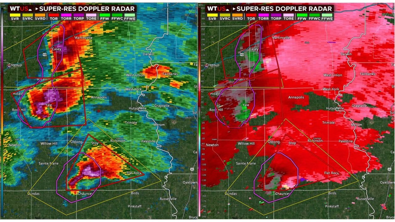
Northern Storms Track Along Warm Front Near Casey and Martinsville
The two northern supercells are positioned along and just north of the warm front, impacting areas near Casey, Martinsville, and Greenup. Radar reflectivity shows intense cores with embedded rotation, particularly west of Casey and extending northward.
Velocity imagery indicates strong low-level wind shear along the warm frontal boundary. Storms riding this boundary can quickly intensify due to enhanced directional shear and localized vorticity.
Communities including Hidalgo and Yale are within the warning polygons, and these storms continue moving east-northeast. Large hail and damaging winds remain possible in addition to tornado development.
Supercell Near Chauncey South of Warm Front Raises Immediate Concern
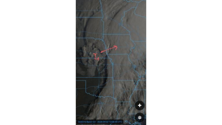
The most dangerous storm at this time is located just north of Chauncey, extending toward Flat Rock and Birds. Unlike the northern storms, this supercell is positioned south of the warm front, meaning it is fully embedded in the warm, unstable air mass.
Radar reflectivity shows a pronounced hook-like appendage on the southern flank of the storm near Chauncey, while velocity data reveals tight rotation within the warned area. Reports indicate a funnel or tornado may already be ongoing with this cell.
Being south of the warm front allows the storm to ingest undisturbed warm, moist inflow, increasing the risk of sustained rotation and stronger tornadic potential over the short term.
Rotation Signatures Confirm Active Tornadic Threat
Dual radar panels show a classic supercell structure with strong inbound and outbound velocity couplets, particularly in the storm near Chauncey and another near Yale. These signatures are consistent with organized mesocyclones capable of producing tornadoes.
The Chauncey storm also displays a compact, intense reflectivity core with a distinct inflow notch, another signal that the storm is well organized and potentially strengthening.
Areas from West Union to Flat Rock Should Be Sheltered
Communities including Casey, Yale, West Union, Annapolis, Chauncey, Flat Rock, Willow Hill, Oblong, and Stoy are either under tornado warnings or in the projected path of these storms.
With three separate tornadic supercells active simultaneously, the environment remains highly supportive of severe weather. Those within warning polygons should be sheltered immediately in a sturdy structure, moving to the lowest level and away from windows.
Storm motion suggests continued eastward progression, which could bring additional communities into warning areas if rotation persists.
If you are experiencing severe weather in your area, share your conditions safely at CabarrusWeekly.com to help others stay informed during this rapidly evolving situation.