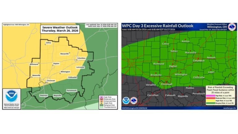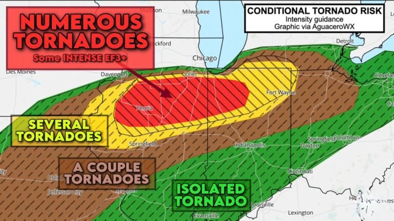
Thursday Severe Weather Trends Show Dryline Setup From Eastern Kansas Into Missouri and Illinois With Cold-Core Tornado Potential
MIDWEST — New forecast trends for Thursday indicate a potentially volatile setup developing from eastern Kansas through Missouri and into Illinois, where moisture may wrap northwestward into a surface low ahead of a dryline.
Recent model guidance highlights a corridor of improving low-level moisture overlapping with steep mid-level lapse rates, creating an environment that could support cold-core severe thunderstorms if destabilization occurs as projected.
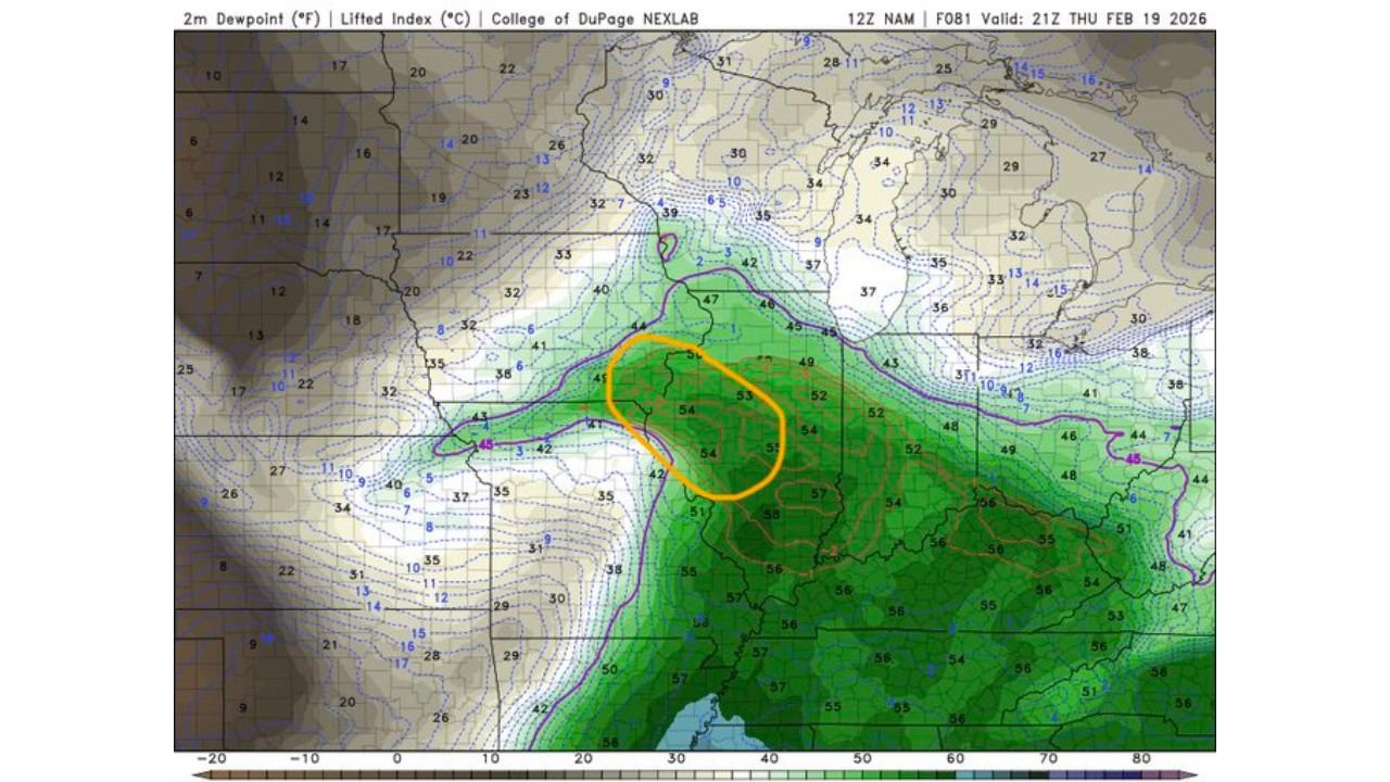
Moisture Return Focused Into Eastern Kansas and Missouri
Dewpoint projections show mid-50s values pushing northward into parts of eastern Kansas, western and central Missouri, and into Illinois, especially near and ahead of a developing surface low.
The critical question remains whether moisture can wrap sufficiently northwestward toward the low center before dry air cuts off instability. If this occurs, storms could develop closer to the low track rather than strictly along the dryline.
More aggressive high-resolution guidance supports this moisture expansion, while global models remain less bullish.
Cold Mid-Level Temperatures Increase Buoyancy
At 500 mb, temperatures near –20°C are projected to overspread the region. That level of mid-level cold air, combined with modest surface moisture, can significantly enhance lapse rates and instability.
This cold-core configuration can promote vigorous updrafts even when surface temperatures are not particularly warm. The overlap of cold air aloft and surface-based moisture is a key ingredient in this setup.
Such environments are known for producing low-topped supercells and cold-core tornadoes, particularly near the surface low.
Dryline Position Will Be Critical
The dryline is expected to sharpen somewhere across eastern Kansas into western Missouri, with drier air to the west and higher dewpoints pooling to the east.
If moisture wraps northwestward into the circulation ahead of the dryline, storm initiation could occur closer to the low. If moisture is limited or suppressed, storm coverage may be more isolated and less intense.
This remains the primary uncertainty in the forecast.
Lapse Rates Support Strong Updrafts
700–500 mb lapse rates appear steep across portions of Missouri, Illinois, and into the Midwest, signaling favorable thermodynamic support for strong storm development.
The combination of strong winds aloft and sufficient instability could support rotating storms if initiation occurs during peak heating Thursday afternoon.
Even if moisture is marginal, cold-core setups can compensate with steep lapse rates and dynamic forcing.
Model Discrepancies Remain
High-resolution guidance is showing more robust moisture return compared to global models, which are less aggressive with northward dewpoint advection.
These differences will determine whether Thursday becomes a more organized severe weather day or a lower-end, localized threat.
As it stands, areas from eastern Kansas through Missouri into Illinois should monitor trends closely as small adjustments in moisture placement will significantly impact storm intensity and coverage.
Residents in the highlighted corridor should stay alert to updated forecasts as confidence increases heading into Thursday. Share your local weather observations and thoughts with CabarrusWeekly.com as this evolving severe weather setup continues to take shape.