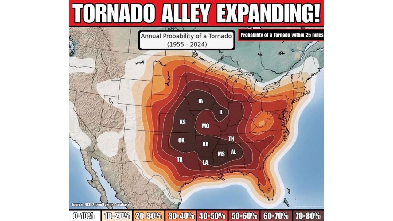
Tornado Alley’s Highest Risk Zone Now Centers on Missouri, Arkansas, and Tennessee as Long-Term Data Shows Eastward Expansion
UNITED STATES — Long-term tornado data from 1955 through 2024 indicates that the nation’s highest annual tornado probability zone is no longer confined strictly to the traditional central Plains, but has expanded eastward into parts of Missouri, Arkansas, Tennessee, and the lower Mississippi Valley.
The updated probability map highlights a broad swath of elevated tornado risk stretching from Texas and Oklahoma through Missouri and into the Mid-South.
Missouri Now Firmly in the High-Probability Core
Missouri stands out prominently within the darker-shaded region indicating a 40–60 percent annual probability of a tornado within 25 miles, according to historical event data.
This places much of Missouri alongside traditionally tornado-prone states such as Kansas and Oklahoma. The data shows that the highest risk contour arcs from central Texas northeast through Oklahoma, Kansas, Missouri, and into Iowa and Illinois.
The concentration of higher probability shading over Missouri reflects decades of recorded tornado events, particularly during spring severe weather seasons.
Arkansas, Tennessee, and Mississippi Also in Elevated Zone
The probability gradient extends southeastward into Arkansas, western Tennessee, Mississippi, and northern Alabama, areas that have increasingly experienced significant tornado activity over recent decades.
These states fall within the 40–60 percent probability contours, with pockets approaching even higher localized risk values.
This reinforces the concept that the traditional “Tornado Alley” footprint has broadened beyond the central Plains.
Traditional Plains Still High — But Not Alone
Texas, Oklahoma, and Kansas remain firmly within the high-probability core, especially across central and eastern sections of those states.
However, the map shows that the maximum concentration of probability shading is no longer isolated strictly to the western Plains. Instead, it forms a wide, continuous belt that includes the Mid-South and portions of the lower Midwest.
Why the Eastward Shift Matters
Several factors contribute to this broader risk corridor, including:
• Frequent Gulf moisture return into the Mississippi Valley
• Strong springtime jet stream dynamics across the Mid-South
• Higher population density increasing report frequency
The Southeast and Mid-South also tend to experience tornado events during both spring and secondary late-fall severe seasons.
Understanding the Probability Scale
The color scale ranges from 0–10 percent up to 70–80 percent annual probability within a 25-mile radius.
The darkest shading, centered over parts of Oklahoma, Kansas, Missouri, Arkansas, and Tennessee, represents the highest long-term risk zones based on nearly seven decades of data.
While no location is guaranteed a tornado in a given year, these probabilities reflect where tornadoes have historically been most frequent.
Bottom Line
Historical tornado data shows that the highest annual risk corridor now clearly includes Missouri, Arkansas, Tennessee, and portions of the Mid-South alongside the traditional central Plains.
Tornado Alley has not disappeared — but the long-term data suggests its most active core has broadened and shifted eastward.
If you live in one of these higher-probability zones, staying prepared during severe weather season remains essential. Share your severe weather experiences and preparedness tips with us at CabarrusWeekly.com.