Tornado Outbreak Potential Peaks Monday And Tuesday From Southern Plains To Great Lakes As Severe Weather Outbreak Sequence Threatens Midwest And Central US With All Hazards Possible
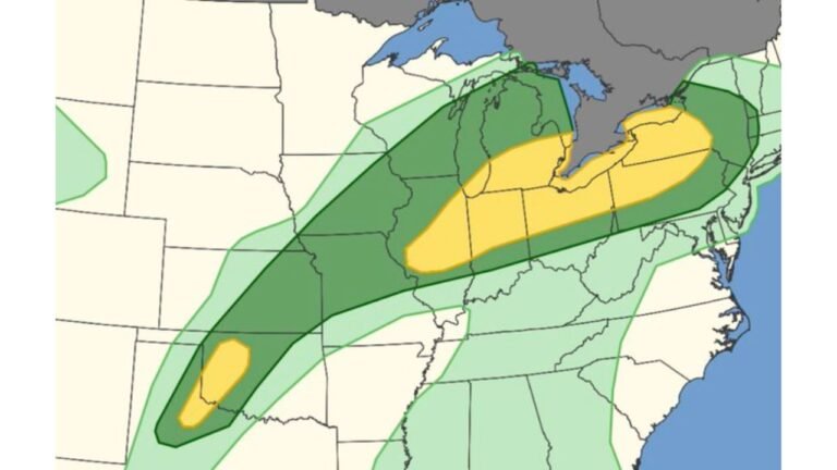
UNITED STATES — A tornado outbreak potential is peaking for Monday and Tuesday, April 13-14, 2026, as a historically active severe weather pattern comes to a head across a massive stretch of the country from the Southern Plains all the way to the Great Lakes region. Forecasters are warning that a severe weather outbreak sequence is possible Monday and Tuesday from parts of the Midwest down to parts of the central United States, with all hazards of severe weather possible.
Massive Warm Sector Fuels Multi-Mode Severe Weather Threat
The engine behind this significant severe weather setup is a massive warm sector opening up Monday and Tuesday, with mid-60s dew points flooding the region — an extraordinary level of atmospheric moisture for mid-April that will provide explosive fuel for severe thunderstorm development.
This setup supports multiple modes of severe weather simultaneously, meaning residents across the affected region could face:
- Supercell thunderstorms capable of producing significant tornadoes
- Squall lines generating widespread damaging winds
- Heavy rainfall across portions of the warm front corridor
- Large hail with any organized storm cells
Tornado Threat Extends Even Into Wisconsin And Michigan Along Warm Front
One of the most notable aspects of this setup is how far north the tornado threat extends. Even the main warm front surging into the Upper Midwest will carry enhanced severe weather, heavy rainfall, and likely tornado potential across Wisconsin and Michigan — states that don’t always find themselves in the heart of tornado country but will be squarely in the risk zone Monday and Tuesday.
Sunday Sets The Stage With Southern Plains Tornado Threat
Before Monday and Tuesday’s main event, Sunday will bring significant severe weather and tornado potential across the Southern Plains, though with more uncertain atmospheric forcing on day one of the dryline setup. Sunday serves as the opening act — a serious threat in its own right — before the pattern fully unleashes its potential heading into the early week.
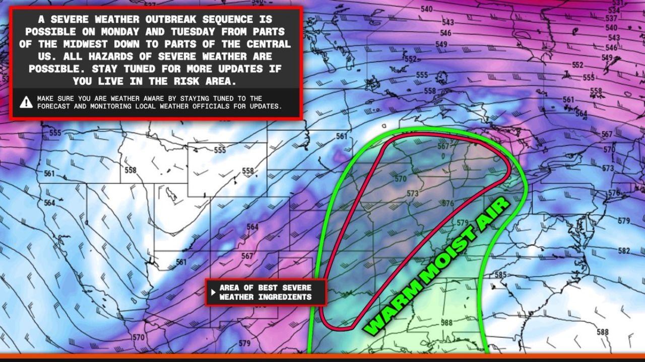
Euro Model Confirms Best Severe Weather Ingredients In Place
The European forecast model (Euro Model, 500mb winds, 6Z run) clearly identifies the area of best severe weather ingredients positioned across the central and eastern United States for Monday and Tuesday. A large pool of warm moist air is shown surging northward into the Midwest, overlapping directly with the best wind shear and atmospheric energy — a textbook recipe for a significant severe weather and tornado outbreak.
This Is A Historically Active Pattern For April
Forecasters are emphatic: this setup sits at the very cusp of a historically active pattern for severe weather and tornadoes this April. The combination of deep moisture, strong wind shear, and a powerful upper-level trough arriving from the west creates the type of atmospheric environment that has historically produced significant tornado outbreaks across the central United States.
Who Is At Risk And What To Do Now
If you live anywhere from the Southern Plains through the Midwest and into the Great Lakes region, now is the time to prepare. All hazards of severe weather are on the table Monday and Tuesday including:
- Significant tornadoes
- Damaging winds
- Large hail
- Heavy rainfall and flooding
Take these steps immediately:
- Identify your shelter location now — do not wait until storms are approaching
- Stay tuned to local weather officials for the latest watches and warnings
- Have a way to receive weather alerts even if power goes out
- Take this threat seriously — this is a potentially historic severe weather pattern for April
Stay with CabarrusWeekly.com for complete and continuing coverage of this dangerous multi-day severe weather outbreak as it develops Monday and Tuesday across the central and eastern United States.