Tornado Risk Expands From South Texas to the Great Lakes as SPC Goes Moderate: Northern Illinois, Northwest Indiana and Rio Grande Valley in Focus
UNITED STATES — After the Storm Prediction Center (SPC) upgraded parts of the Midwest to a Moderate (Level 4 of 5) severe weather risk, attention is now centered on a broad tornado corridor stretching from South Texas to the Great Lakes.
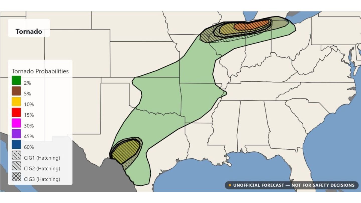
An independent tornado forecast issued prior to the SPC upgrade outlined two primary areas of concern: one across northern Illinois into northwest Indiana, and another near the Rio Grande Valley in South Texas. With the official Moderate risk now in place across the Midwest, confidence is increasing that at least one of these zones could see significant tornado activity.
Northern Illinois and Northwest Indiana: Highest-End Threat
The most intense portion of the forecast stretches across northern Illinois into northwest Indiana, including areas near:
- Chicago metropolitan region
- Joliet
- Peoria
- Kankakee
- Portions of northwest Indiana
Within this corridor, higher-end tornado probabilities were highlighted, including a zone supporting stronger tornado potential. The shading and hatching indicate a setup capable of organized, rotating supercells in an environment favorable for tornado development.
This region now aligns closely with the SPC’s Moderate risk upgrade, suggesting that several tornadoes are possible, and that a few could become strong.
Secondary Concern: Rio Grande Valley and Deep South Texas
A second tornado zone appears across South Texas near the Rio Grande Valley.
Communities in this area could see isolated to scattered tornado development if storms form and remain discrete. While coverage is expected to be lower than in the Midwest corridor, atmospheric conditions are supportive enough to warrant attention.
This southern zone includes:
- Areas near the Texas–Mexico border
- Portions of far South Texas extending inland
Storm mode will play a critical role. If isolated supercells develop, tornado potential increases. If storms quickly merge into clusters, the threat may shift more toward damaging winds and hail.
Broad Corridor From Texas to the Great Lakes
Between these two highlighted regions, a broader low-end tornado risk extends northward through:
- Eastern Texas
- Arkansas
- Missouri
- Illinois
- Into the southern Great Lakes region
This green-shaded area represents lower tornado probabilities but still indicates a supportive environment for isolated tornado development along the larger storm system.
SPC Moderate Upgrade Adds Weight
The SPC’s decision to elevate parts of Illinois and Indiana to a Moderate risk significantly raises concern for the northern portion of the corridor. Moderate risks are not issued lightly and typically signal heightened confidence in impactful severe weather.
In this case, the environment features:
- Strong wind shear
- Sufficient instability
- Favorable conditions for sustained supercell development
If storms remain organized and discrete across northern Illinois and northwest Indiana, tornado intensity could increase quickly.
Key Takeaways
- Northern Illinois and northwest Indiana now sit in the most concerning tornado zone.
- The Rio Grande Valley in South Texas remains a secondary but notable risk area.
- A broader corridor from Texas to the Great Lakes supports at least isolated tornado potential.
- Storm structure will determine whether the threat leans toward stronger tornadoes or transitions into more linear wind-producing systems.
Bottom Line
With the SPC upgrading the Midwest to a Moderate risk and earlier forecasts already highlighting northern Illinois and northwest Indiana, confidence is growing in a potentially active tornado day across parts of the country.
Residents in both the Midwest and South Texas should remain weather aware, monitor official updates, and be prepared to act quickly if warnings are issued.
CabarrusWeekly.com will continue tracking developments as this evolving severe weather situation unfolds.