Tornado Risk Near Kansas City Friday as Severe Storm Ingredients Align Across Missouri, Kansas and Oklahoma
KANSAS CITY, MO — A developing severe weather setup across the central Plains is drawing attention Friday, with the Storm Prediction Center outlining a tornado risk area that includes Kansas City and surrounding portions of Missouri and Kansas.
While social media discussion has amplified concerns, the data shows a situation that warrants awareness — not panic.
What the SPC Outlook Shows
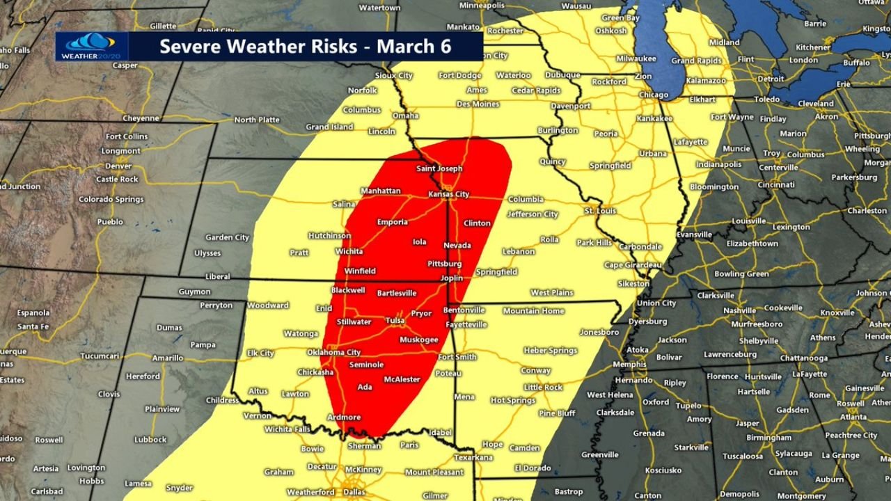
The NOAA Storm Prediction Center’s Day 2 tornado outlook highlights:
- A yellow hatched tornado risk area extending from central Oklahoma through eastern Kansas into western and central Missouri
- Kansas City included within the 10% tornado probability zone
- A higher concentration of severe weather potential stretching from Oklahoma City and Tulsa north through Wichita, Emporia, and into the Kansas City metro
A 10% tornado probability means there is a 10% chance of a tornado occurring within 25 miles of any given point inside the outlined area. It also means there is a 90% chance that a tornado does not occur within that same radius.
Areas of Greatest Concern
The severe weather risk zone covers several key cities, including:
- Oklahoma City
- Tulsa
- Stillwater
- Wichita
- Emporia
- Manhattan
- Kansas City
- St. Joseph
- Pittsburg, KS
Farther south, communities near Ardmore, Ada, McAlester, and Seminole in Oklahoma also fall within the higher-end severe zone.
Ingredients May Come Together Friday Afternoon
Forecast discussions suggest that the environment could support:
- Damaging wind gusts
- Large hail
- Isolated tornadoes
However, severe weather near Kansas City often depends on whether all atmospheric ingredients align properly. In some setups, instability fails to fully develop, or surface heating is limited, which can reduce the overall threat.
At this point, model guidance indicates that Friday afternoon into Friday evening is the primary window for storm development.
Balancing Risk and Reality
History shows that many severe setups in the Kansas City region appear strong on paper but fall short when a key ingredient is missing. Other times, storms do intensify and produce damaging weather.
The key takeaway:
- The threat is real and should be monitored.
- It is not a guarantee of tornado activity.
- Preparation is appropriate; panic is not.
Residents across eastern Kansas, western Missouri, and northern Oklahoma should:
- Review severe weather safety plans
- Ensure weather alerts are enabled
- Monitor forecast updates through Friday
CabarrusWeekly.com will continue tracking developments as Friday approaches. If stronger thunderstorms begin to organize, updates will follow as storms threaten populated areas across the central Plains.