Tornado Risk Upgraded to MODERATE (Level 4/5): Illinois and Indiana Brace for Potential EF2–EF3+ Twisters This Afternoon and Tonight
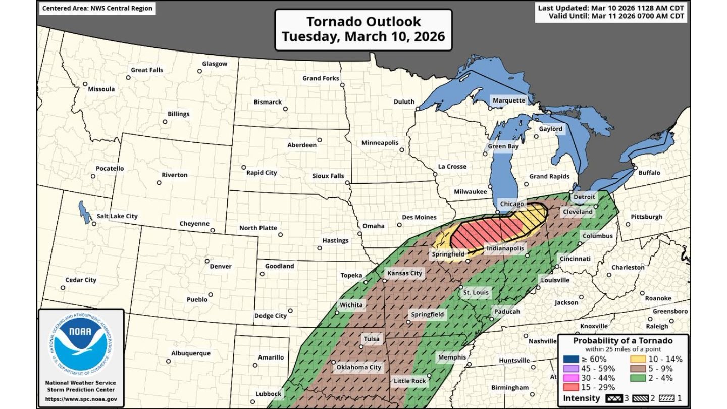
UNITED STATES — The Storm Prediction Center (SPC) has upgraded today’s tornado outlook to a 15% risk with a CIG2 (significant) outline, placing parts of Illinois and Indiana under a Level 4 out of 5 MODERATE risk for severe weather.
Forecasters warn that several tornadoes are possible this afternoon and tonight, including a few that could become strong to intense — rated EF2 to EF3+ — and potentially long-tracked.
Moderate Risk Centered on Illinois and Indiana
The upgraded tornado outlook for Tuesday, March 10, highlights a concentrated corridor stretching from central Illinois into central Indiana.
Cities near or within the higher-end risk zone include:
- Springfield, Illinois
- Indianapolis, Indiana
- Areas south and east of Chicago
- Portions of western and central Indiana
The broader severe weather corridor extends southwest through Missouri, eastern Kansas, eastern Oklahoma, and into parts of Arkansas, but the most concerning tornado parameters are focused across Illinois and Indiana.
What a 15% Tornado Risk Means
A 15% tornado probability within 25 miles of a point — especially with a significant (CIG2) designation — signals an elevated potential for stronger tornadoes.
In practical terms, this setup supports:
- Multiple tornadoes
- A few strong tornadoes (EF2–EF3+)
- The possibility of long-track tornadoes if storms remain organized
This level of risk is not routine. A Level 4 Moderate risk is issued sparingly and typically reserved for days when confidence is high in widespread severe weather.
Dangerous Atmospheric Setup
Meteorologists describe this as a dangerous situation due to:
- Strong wind shear (changing wind speeds and directions with height)
- Ample instability
- A favorable environment for rotating supercells
If discrete supercells develop and remain isolated ahead of any storm lines, they could tap into these conditions and produce strong tornadoes capable of causing significant damage.
Storms are expected to intensify through the afternoon and persist into the evening hours, increasing concern for both daylight and after-dark tornado potential.
Timing and Greatest Concern
The primary tornado window spans this afternoon through tonight, with peak intensity likely during the late afternoon and evening.
Communities across central and eastern Illinois and into central Indiana should remain especially alert.
Residents near:
- Springfield
- Indianapolis
- Surrounding rural communities between the two cities
should closely monitor watches and warnings as storms evolve.
This Is Not a Routine Severe Day
The SPC explicitly characterizes the setup as dangerous. When Moderate risk levels are issued with a significant tornado outline, it signals a heightened probability of impactful events.
Preparation steps include:
- Ensuring multiple ways to receive warnings
- Reviewing shelter plans
- Avoiding complacency, especially during evening hours
Bottom Line
Parts of Illinois and Indiana are now under a Level 4 of 5 Moderate tornado risk, with a 15% significant tornado probability. Several tornadoes are possible today, including strong EF2–EF3+ and potentially long-tracked storms.
Residents across the region should remain weather aware throughout the afternoon and evening as this potentially dangerous severe weather situation unfolds.
CabarrusWeekly.com will continue to monitor updates as forecasters refine the outlook.