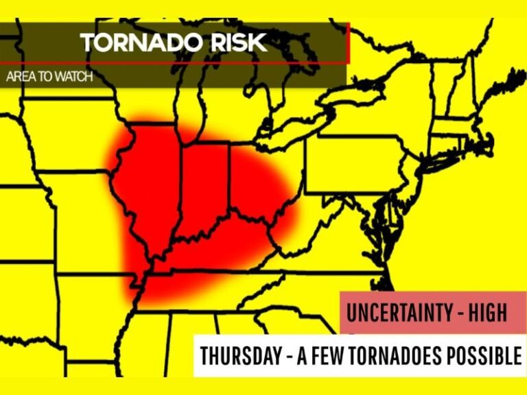
Tornado Threat Intensifies Across Eastern Ohio and Western Pennsylvania: Mini Supercells Target Akron, Youngstown, Canton and Pittsburgh With EF2+ Risk Not Ruled Out
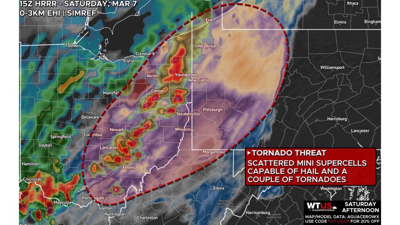
EASTERN OHIO — A developing tornado threat is taking shape this afternoon across portions of the Eastern Ohio Valley, where forecasters warn that scattered mini supercells could rapidly intensify in a strongly sheared and moderately unstable environment.
The greatest concern centers on Eastern Ohio into Western Pennsylvania, including communities such as Akron, Canton, Youngstown, Steubenville, Athens, Newark, and Columbus, extending east toward Pittsburgh and New Castle.
Why This Setup Is Concerning
High-resolution model guidance indicates strengthening low-level instability combined with intense wind shear in the lowest few thousand feet of the atmosphere. This environment favors:
- Rotating thunderstorms
- Quick spin-up tornadoes
- Brief but potentially strong circulation development
Storms are expected to develop within the next couple of hours and may organize into scattered mini supercells rather than one solid line. These discrete cells are often capable of producing sudden, localized severe weather.
Primary Threats This Afternoon
Tornado Risk
Forecasters indicate that a couple of tornadoes are possible, particularly across Eastern Ohio. While not every storm will rotate, any cell that does could produce a brief tornado. Importantly, a significant tornado (EF2 or stronger) cannot be ruled out if a storm fully taps into the available instability and shear.
Damaging Wind Gusts
Strong gusts will be possible with the most intense storms, especially as cells mature and move northeast across the region.
Hail Potential
Some storms may also produce hail, particularly within the stronger rotating updrafts.
Areas Most Impacted
The corridor of concern stretches from:
- Near Columbus and Newark
- Northeast through Akron and Canton
- Into Youngstown
- Crossing into Western Pennsylvania, including Pittsburgh
Cities near the Ohio–Pennsylvania border appear especially vulnerable during peak afternoon heating.
Timing
The tornado threat is expected to unfold during the afternoon hours as storms develop and track northeast. Conditions are favorable for rapid storm strengthening during peak daytime heating before activity gradually shifts eastward later in the day.
What Residents Should Do
With mini supercells, storms can intensify quickly and produce warnings with little lead time. Residents across Eastern Ohio and Western Pennsylvania should:
- Monitor weather alerts closely
- Keep mobile devices charged
- Identify a safe shelter location in advance
- Be prepared to act quickly if a warning is issued
Bottom Line
The Eastern Ohio Valley faces a legitimate tornado threat this afternoon, driven by strong low-level shear and sufficient instability. While not an outbreak scenario, the setup supports scattered rotating storms capable of hail, strong winds, and possibly a couple of tornadoes — including the potential for a stronger EF2+ event.
CabarrusWeekly.com will continue monitoring developments as storms begin to fire across the region.