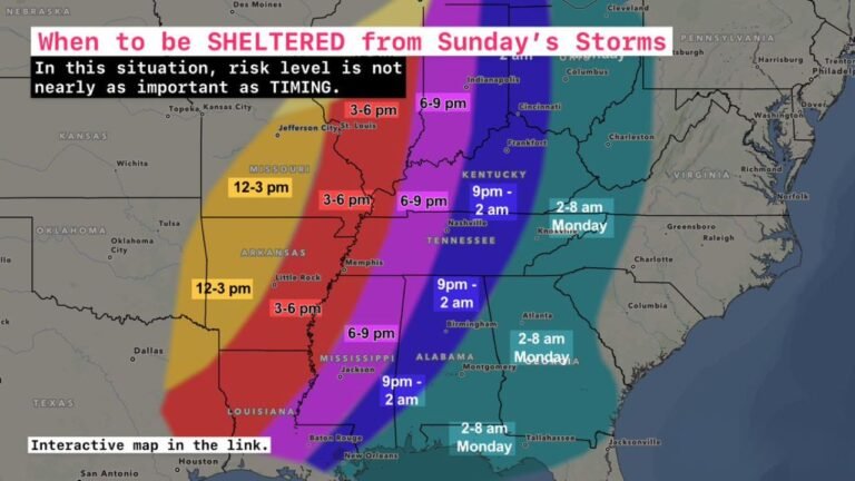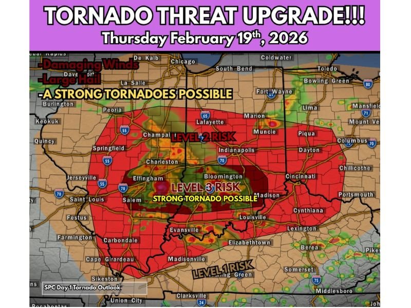
Tornado Threat Upgraded Across East-Central Illinois and Central Indiana as EF2+ Risk Emerges Thursday Afternoon
ILLINOIS — A significant tornado threat upgrade has been issued for Thursday, February 19, 2026, with a corridor of higher tornado potential stretching from east-central Illinois into central Indiana, including the risk for strong to significant tornadoes (EF2+) during the afternoon and evening hours.
The most concerning timeframe for tornado development is expected between 1 p.m. and 8 p.m., when atmospheric conditions are projected to be most supportive of rotating supercells.
Level 3 Risk Centered Near Indianapolis and Bloomington
Forecast guidance highlights a Level 3 risk zone centered from around Effingham and Charleston, Illinois, eastward through Bloomington, Indiana, and toward areas near Indianapolis. This corridor carries the highest probability for strong tornado development.
Within this region, environmental parameters suggest storms could become semi-discrete supercells capable of producing:
- Strong tornadoes (EF2 or greater)
- Damaging straight-line winds
- Large hail
The risk area also includes communities along major interstates such as I-70, I-65, and I-55, placing several populated corridors within the enhanced threat zone.
Broader Level 2 Risk Extends Across Illinois and Indiana
Surrounding the higher-end core, a broader Level 2 risk covers much of central and southern Illinois and Indiana. Cities including Springfield, Champaign, Lafayette, Muncie, Dayton, and Cincinnati fall within this expanded threat area.
While tornado intensity may vary outside the Level 3 zone, the overall setup still supports severe thunderstorms capable of:
- Damaging wind gusts
- Large hail
- Isolated tornadoes
Storm development is expected to intensify through the afternoon as instability increases and wind shear strengthens across the region.
Damaging Winds and Large Hail Also Likely
Beyond the tornado risk, forecasters emphasize that damaging winds and large hail are likely with the strongest storms. Any supercell that forms ahead of the main line could rotate efficiently in this environment.
Areas south of the primary corridor, including portions of Kentucky near Louisville and Madison, remain in a lower but still notable risk zone where severe storms are possible.
Weather Awareness Strongly Encouraged
Residents across east-central Illinois and central Indiana are urged to remain weather aware throughout the afternoon and evening. Conditions will evolve rapidly, and warnings may be issued with little lead time once storms begin to rotate.
This upgraded outlook signals increasing confidence in a more organized severe weather setup compared to earlier forecasts. Stay with CabarrusWeekly.com for continued updates as this severe weather threat unfolds. If you have family or travel plans in the affected region, now is the time to review safety plans and ensure you have multiple ways to receive warnings.