Tornado Warnings Issued as Three Supercells Target Casey, Yale, and Flat Rock Areas in Illinois with Escalating Long-Track Risk
ILLINOIS — Multiple tornadic supercells are actively tracking across eastern Illinois this evening, with tornado warnings in effect for communities including Casey and Yale, while a third storm west of Flat Rock shows increasing long-term tornado potential.
Tornado Warnings Cover Casey and Yale as Rotating Storm Intensifies
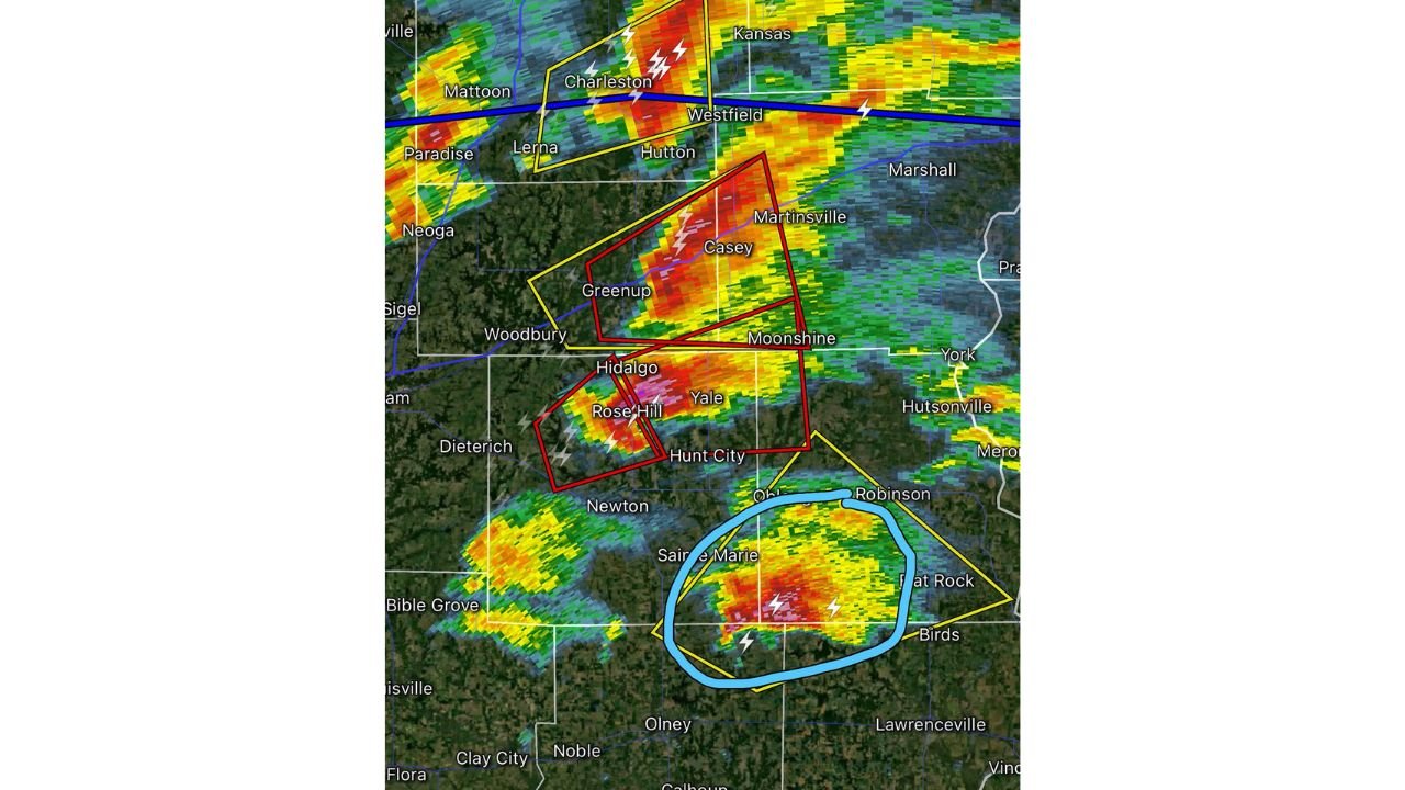
Radar imagery shows a powerful supercell moving through Casey, Greenup, Hidalgo, and toward Yale, producing intense reflectivity cores and frequent lightning. A tornado warning polygon encompasses much of this corridor, including Moonshine and Hunt City, indicating strong low-level rotation embedded within the storm.
The radar presentation suggests a classic supercell structure, with a concentrated red and pink reflectivity core near Rose Hill and Hidalgo, a common signature of large hail and strong updraft strength. The presence of tight warning boxes overlapping Casey and surrounding communities indicates ongoing radar-indicated rotation capable of producing a tornado.
Residents in Casey and Yale should treat this situation as dangerous and evolving, as the storm continues tracking east-northeast.
Second Supercell Impacts Charleston and Westfield Corridor
To the north, another tornadic supercell has prompted warnings for Charleston and Westfield, with the storm extending toward Kansas, Illinois. Radar shows a pronounced band of intense reflectivity crossing near Mattoon and Lerna, with lightning density indicating vigorous storm activity.
The warning polygon stretching from Charleston toward Westfield highlights continued rotation and possible tornado development. While this northern storm is dangerous, forecasters are particularly monitoring the southern cell due to its environmental positioning and inflow access.
Southern Supercell Near Flat Rock Shows Stronger Long-Track Tornado Potential
The most concerning storm at this time is located west of Flat Rock, extending between Saint Marie, Robinson, Birds, and Olney. Radar shows a well-defined supercell structure with a large, intense core of red reflectivity and frequent lightning signatures.
Meteorological analysis indicates this storm has access to clean, uninterrupted inflow, meaning it is drawing warm, moist air into its updraft without interference from nearby storms. This configuration can support sustained rotation and increase the risk of a longer-track tornado, especially if the storm remains isolated.
The warning polygon surrounding this southern storm covers areas from near Robinson southward and west of Flat Rock, signaling heightened concern for communities along its projected path.
Storm Environment Favors Continued Rotation
All three storms are embedded within a broader severe weather environment characterized by strong instability and organized wind shear. The alignment of reflectivity cores and warning polygons suggests the storms are maintaining structure rather than weakening.
When supercells remain discrete and tap into undisturbed inflow, they can sustain rotation for extended periods. The southern storm west of Flat Rock currently appears to have the most favorable setup for maintaining strength, making it the primary storm to watch through the evening hours.
Communities in Path Should Take Immediate Precautions
Residents in Casey, Greenup, Hidalgo, Rose Hill, Yale, Charleston, Westfield, Saint Marie, Robinson, and Flat Rock should remain weather-aware. If a tornado warning is issued for your location, move immediately to an interior room on the lowest floor of a sturdy building.
Storm motion suggests continued east-northeast movement, meaning additional communities downrange could come under warnings if rotation persists.
Severe weather situations like this can evolve rapidly. Continue monitoring trusted weather sources and local alerts as these supercells track across eastern Illinois.
If you are in any of the warned areas, share your conditions and reports safely in the comments section at CabarrusWeekly.com so others can stay informed.