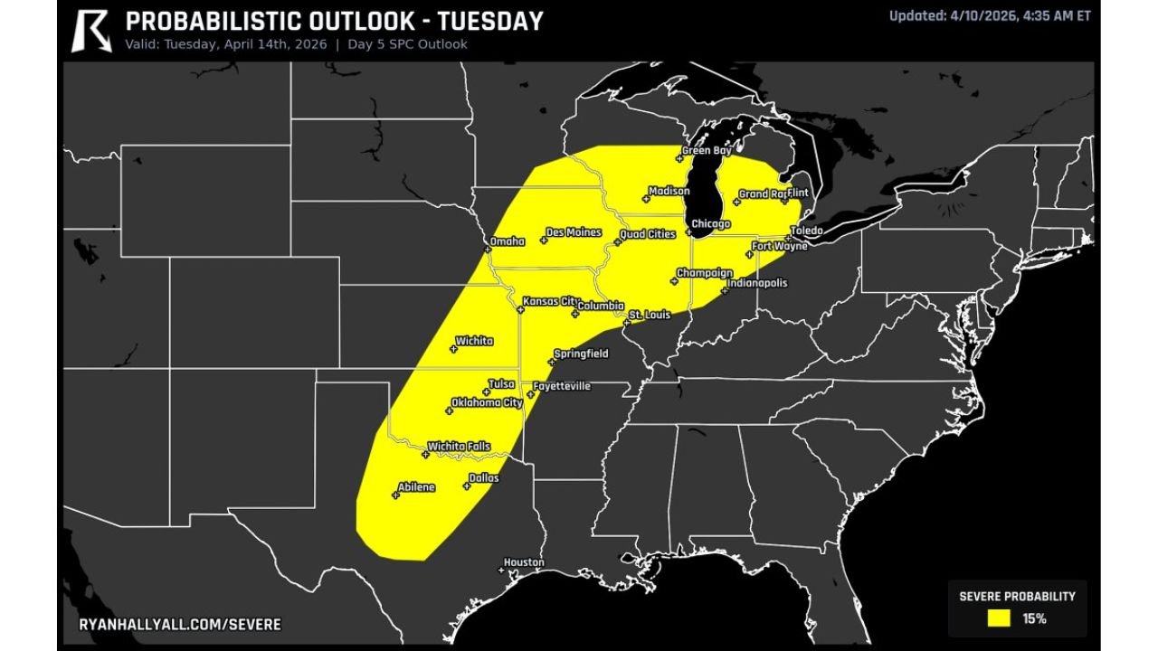
Tuesday Severe Weather Threat May Stretch From Texas Dryline Through Oklahoma, Missouri and Illinois Into Great Lakes With Tornadoes, Large Hail and Wind Risk
UNITED STATES — A potentially expansive severe weather setup is expected to develop Tuesday, with storms possibly stretching from the Southern Plains all the way into the Great Lakes region.
Storm Corridor Extends From Texas to Great Lakes
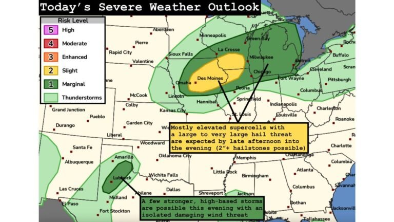
Forecast data highlights a broad severe weather zone beginning near the Texas dryline and extending through Oklahoma, Kansas, Missouri, Illinois, and into parts of the Great Lakes, including areas near Wisconsin and Michigan.
This setup suggests a large geographic footprint, with multiple states facing the risk of organized thunderstorms.
Supercells Capable of All Severe Hazards
The environment is expected to support supercell thunderstorms, which are capable of producing the most dangerous forms of severe weather.
Across this corridor, all hazards are possible, including:
tornadoes, large hail, and damaging wind gusts.
Storms forming along the dryline and advancing eastward could intensify as they move into more moisture-rich air.
Key Focus Areas Include Plains Into Midwest Cities
Major population centers within the risk zone include Dallas, Oklahoma City, Wichita, Kansas City, St. Louis, Chicago, and surrounding regions.
These areas may see storms develop or track through during the day, increasing the potential for impacts across both urban and rural locations.
Forecast Uncertainty Remains on Storm Placement
One of the key challenges in this forecast is timing and speed of the upper-level system, which will determine exactly where the most intense storms develop.
Small shifts in the system’s movement could change whether the highest risk remains in the Plains or shifts farther east into the Midwest and Great Lakes.
Timing and Storm Evolution
The most active period is expected during Tuesday afternoon into the evening, when instability and storm organization are likely to peak.
Storms may begin in the Plains and then track northeast, potentially affecting multiple states over several hours.
What This Means Going Forward
This setup represents a high-end potential severe weather day, especially given the large area involved and the possibility for all severe hazards.
While details will continue to evolve, residents from Texas through the Midwest and into the Great Lakes should stay alert for updates as confidence increases.
Stay with CabarrusWeekly.com for continued coverage, and share what conditions you are seeing in your area as this severe weather threat develops.