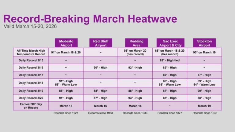
Two Severe Weather Risk Areas Outlined in SPC Day 4–8 Outlook, Targeting Southern Plains and Missouri Valley Midweek Into Friday
UNITED STATES — The Storm Prediction Center has outlined two separate 15% severe weather risk areas in its extended Day 4–8 outlook, signaling increasing confidence in organized storms developing across the Southern Plains midweek and expanding into the Missouri Valley by Friday.
Day 4 (Wednesday): Southern Plains Targeted for Severe Gusts and Hail
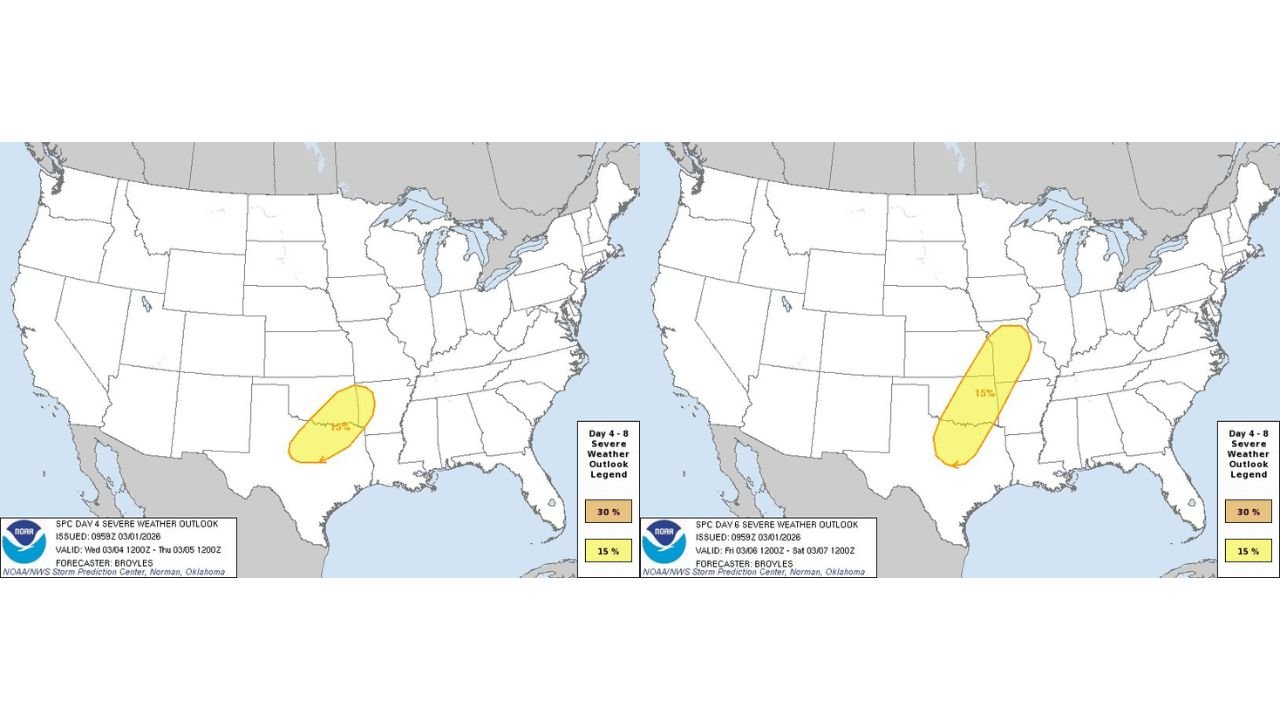
The first highlighted risk zone appears on Day 4, Wednesday, centered over portions of Texas and Oklahoma, extending into parts of southern Kansas.
The outlook places a 15% probability area across this region, indicating a corridor where severe thunderstorms are becoming increasingly possible during the afternoon and evening hours.
Primary hazards within this zone include:
- Damaging wind gusts
- Large hail
The setup suggests strengthening instability combined with upper-level support could allow storms to intensify quickly as daytime heating peaks. While tornado potential is not emphasized in this initial risk area, any stronger supercell structures could still require close monitoring.
Day 6 (Friday): Broader Severe Threat From Southern Plains Into Missouri Valley
A second and more expansive risk area appears on Day 6, Friday, stretching from the Southern Plains northeastward into the Missouri Valley.
This 15% corridor includes parts of:
- Central and eastern Texas
- Oklahoma
- Arkansas
- Missouri
- Eastern Kansas
The elongated shape of the highlighted region suggests a more organized system, possibly associated with a strengthening surface low and advancing cold front.
The SPC notes that damaging wind gusts and severe hail appear to be the primary hazards, though language in the outlook indicates that a tornado threat may exist as well, depending on how moisture return and wind shear parameters evolve.
Expanding Storm Corridor Indicates Increasing Confidence
When the SPC issues Day 4–8 risk areas, it reflects growing confidence in the broader pattern alignment for severe weather. A 15% zone at this range is significant and often precedes more refined outlooks as the event approaches.
The transition from a more compact Southern Plains risk on Wednesday to a broader Plains-to-Missouri Valley corridor by Friday suggests:
- An eastward progression of the storm system
- Increasing moisture transport from the Gulf of Mexico
- Strengthening upper-level dynamics
If trends continue, later outlooks could refine or expand risk levels as mesoscale details become clearer.
What This Means Going Forward
Residents across the Southern Plains midweek and the Missouri Valley by Friday should monitor forecast updates closely. While these are still medium-range outlooks, the early signal of organized severe weather potential highlights the need for preparedness.
Damaging winds and large hail remain the primary concerns at this stage, but evolving wind profiles could introduce additional threats depending on storm structure and timing.
We will continue monitoring forecast refinements as higher-resolution models come into range.
If you are located in Texas, Oklahoma, Kansas, Arkansas, or Missouri, stay alert to updated briefings and share any severe weather impacts with us at CabarrusWeekly.com as the pattern unfolds.