Upper Midwest Tornado Setup Taking Shape Saturday as Warm, Moist Air Surges Into Wisconsin, Illinois and Michigan
UNITED STATES — A potentially volatile setup is developing for Saturday, March 7, 2026, across parts of the Upper Midwest, where a strengthening low-pressure system and a surge of Gulf moisture could align for severe thunderstorms — including possible tornadoes.
Forecast guidance from the ECMWF model shows a classic spring configuration beginning to take shape over Minnesota, Wisconsin, Illinois and Michigan, with questions remaining about instability and early-day storm interference.
Low Pressure Tracking Near Minnesota and Wisconsin
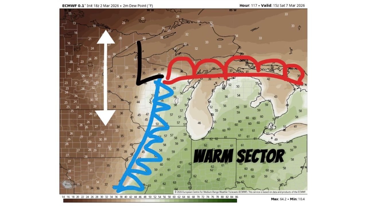
Model data valid 15z Saturday (late morning) places a surface low near southern Minnesota into western Wisconsin, with colder, drier air wrapping in from the west.
Dew point temperatures north and west of the low are largely in the 20s and 30s, indicating a cooler, more stable air mass across:
- Northern Minnesota
- Northern Wisconsin
- Upper Michigan
This sharp contrast sets the stage for a defined boundary between cool air to the north and warm, moist air to the south.
Warm Sector Expands Across Illinois, Indiana and Michigan
South of the low, dew points climb into the mid to lower 60s across:
- Central and southern Illinois
- Indiana
- Southern Michigan
- Northern Ohio
This area, often referred to as the warm sector, is where instability can build ahead of an advancing cold front.
If surface heating occurs and morning convection does not disrupt the air mass, storms developing along the cold front or near the warm front could become organized and severe.
Key Questions: Instability Access and Morning Convection
While the ingredients are visible, uncertainty remains.
Forecasters are watching for:
- Low placement accuracy — Small shifts north or south could significantly alter the tornado corridor.
- Morning storm activity — Early convection could limit daytime heating and reduce instability.
- Moisture depth — Whether 60°+ dew points can fully advect northward into Wisconsin and southern Michigan.
If instability remains intact into the afternoon, discrete supercells could develop ahead of the main line.
Areas to Watch Closely
Based on current guidance, the most favorable corridor for severe weather Saturday appears to include:
- Madison, WI
- Milwaukee, WI
- Chicago, IL
- Rockford, IL
- Grand Rapids, MI
- Detroit, MI
These areas sit near the intersection of strong wind shear, increasing moisture, and proximity to the surface low.
Broader Severe Pattern Continues
This Upper Midwest threat follows an already active severe weather pattern across the Plains earlier in the week, signaling that the 2026 tornado season is ramping up quickly.
If the system evolves as currently projected, parts of the Midwest could see:
- Large hail
- Damaging winds
- Isolated tornado potential
What This Means for North Carolina
Although this setup is centered well north of North Carolina, large-scale trough patterns often progress eastward. Should the system remain strong into early next week, portions of the Southeast — including North Carolina — may eventually enter a broader severe weather regime.
Cabarrus County residents should use this as a reminder that spring severe weather season is underway nationally.
CabarrusWeekly.com will continue monitoring the evolution of this Upper Midwest system and provide updates if the broader pattern trends toward the Carolinas.