Utah and Wyoming Facing 50+ MPH Wind Gusts Saturday as Cold Front Sweeps Through Salt Lake City, Provo and Rock Springs
UTAH — Strong winds are expected to ramp up Saturday afternoon and continue into the night as a cold front moves through Utah and southern Wyoming, bringing gusts that could exceed 50 mph in several locations.
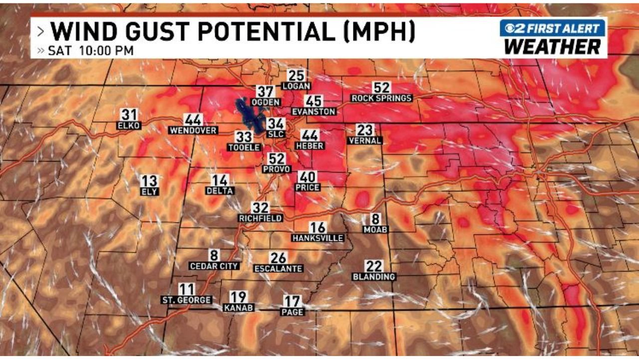
Forecast wind gust potential maps show the strongest winds centered across northern Utah and into southwest Wyoming, with elevated terrain seeing even higher gusts.
50+ MPH Gusts in Northern Utah and Southwest Wyoming
Projected gusts by Saturday evening include:
- Provo: around 52 mph
- Rock Springs: near 52 mph
- Evanston: around 45 mph
- Heber: near 44 mph
- Wendover: around 44 mph
- Ogden: mid to upper 30s mph
- Salt Lake City (SLC): mid-30s mph
These values indicate widespread gusty conditions, with some mountain and canyon areas potentially experiencing stronger localized winds.
Travel Impacts Likely
With gusts over 50 mph possible, travel could become difficult at times — particularly for high-profile vehicles such as:
- Tractor-trailers
- RVs
- Box trucks
- Vehicles towing trailers
Interstate corridors across northern Utah and into southern Wyoming may experience crosswinds strong enough to require extra caution.
Blowing Dust and Reduced Visibility
In lower elevation areas, especially where soils are dry, blowing dust may develop. Reduced visibility is possible in localized areas, particularly in open desert regions and along east-west oriented roadways.
Drivers should be prepared for sudden visibility drops.
Gusty Conditions Outside the Mountains
Even outside of mountainous terrain, widespread gusts in the 30–45 mph range are expected across central and southern Utah, including:
- Richfield (low 30s mph)
- Price (around 40 mph)
- Escalante (mid-20s mph)
- St. George (lower teens to around 20 mph)
Mountain passes and exposed ridgelines could see stronger gusts than surrounding valleys.
Secure Outdoor Items Before Winds Arrive
Residents are encouraged to take a few minutes Saturday before winds intensify to:
- Secure patio furniture
- Anchor trampolines
- Bring in trash bins
- Tie down loose outdoor decorations
Loose objects can quickly become airborne in 50+ mph wind gusts.
Timing: Saturday Afternoon Into Saturday Night
Winds are expected to increase Saturday afternoon, peak during the evening hours, and remain breezy into the overnight period as the cold front clears the region.
Bottom Line
Utah and southwest Wyoming are preparing for a windy Saturday, with gusts exceeding 50 mph possible in areas like Provo and Rock Springs and widespread 30–45 mph gusts elsewhere.
Travel difficulties, blowing dust and minor damage from unsecured objects are possible. Residents should secure loose items and use caution on the roads.
CabarrusWeekly.com will continue monitoring updates as the cold front moves through the region.