Utah Mountains to Receive 3 to 11 Inches of Snow Tuesday Through Wednesday With Alta, Cottonwood Canyons, and Brian Head in the Heaviest Zone Before a Second Colder Storm Arrives Thursday Through Friday
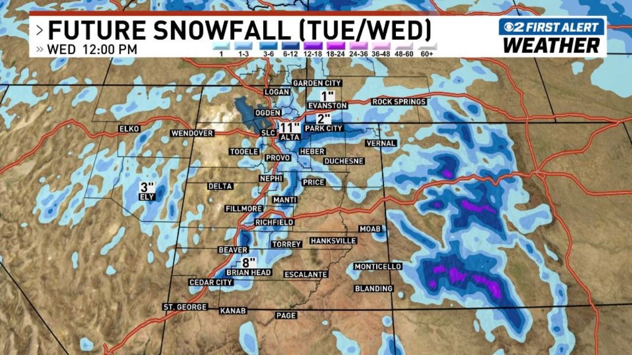
SALT LAKE CITY, UTAH — Utah’s mountain communities and ski resorts are in for a significant late-season snow event starting Tuesday afternoon, March 31 and continuing through Wednesday morning, April 1, 2026. Snowfall totals across the Wasatch Range and southern Utah mountains are forecast to reach 3 to 8 inches broadly, with the highest terrain picking up considerably more. Alta and the Cottonwood Canyons are forecast to see up to 11 inches at the upper elevations — a substantial late-March powder dump that will refresh snowpack across one of the country’s premier ski corridors. And before the week is over, a second and colder storm is set to move in Thursday through Friday, bringing additional accumulations on top of what falls tonight and tomorrow.
Where the Heaviest Snow Falls Tuesday Through Wednesday
The storm’s heaviest snowfall will be concentrated across the central and southern Wasatch Range — Utah’s most prominent mountain spine running directly east of Salt Lake City — and across the Brian Head area in southern Utah.
Alta and the Cottonwood Canyons sit at the top of the accumulation forecast with up to 11 inches possible at the highest elevations by Wednesday midday. Alta — consistently ranked among the snowiest ski resorts in North America — is positioned directly in the path of the heaviest moisture band with this storm, and the combination of elevation and terrain funneling will squeeze maximum snowfall out of the passing system. The Cottonwood Canyons as a whole — including both Big Cottonwood and Little Cottonwood — are forecast to see 5 to 10 inches, making Tuesday night through Wednesday morning one of the better powder windows of the late season.
Brian Head in southern Utah is the other notable accumulation location — forecast to pick up around 8 inches from this system, a significant total for a resort that sits at over 11,000 feet elevation and regularly sees late-season storms through April.
Further north, Park City and Evanston are forecast to receive around 2 inches — lighter totals that reflect their position on the eastern edge of the storm’s moisture band. Logan and Garden City near the Idaho border are at the 1-inch range.
The broader Utah mountain forecast calls for 3 to 8 inches across most mountain zones through Wednesday morning — enough to meaningfully refresh snowpack and provide solid skiing conditions across the state’s resorts heading into April.
Snowfall Forecast by Location — Tuesday PM Through Wednesday AM
| Location | Expected Snowfall |
|---|---|
| Alta / Upper Cottonwood elevations | Up to 11″ |
| Cottonwood Canyons (Big & Little) | 5–10″ |
| Brian Head | 8″ |
| General Utah mountains | 3–8″ |
| Park City | 2″ |
| Evanston, Wyoming | 2″ |
| Logan / Garden City | 1″ |
| Ely, Nevada | 3″ |
Forecast Confidence Level
High confidence on heavy snowfall across Alta and the Cottonwood Canyons — the storm track and moisture setup are consistent across forecast models for the Tuesday night through Wednesday morning window.
High confidence on Brian Head receiving 6 to 8 inches** — southern Utah’s higher terrain is well-positioned to intercept significant moisture from this system.
Medium confidence on exact totals at lower elevation mountain locations** — Park City, Logan, and Evanston totals could vary by an inch or two depending on the exact storm track and precipitation timing overnight.
High confidence on the second storm arriving Thursday through Friday** — the colder follow-up system is well-established in forecast data, though exact accumulation totals for that event will become clearer by Wednesday.
The Second Storm — Thursday Through Friday
Tuesday night’s snowfall is only the first chapter of Utah’s late-week mountain snow story. A second and colder storm system is forecast to move into Utah Thursday through Friday, April 2–3 — bringing additional snowfall accumulations on top of the fresh powder from tonight’s event.
The Thursday-Friday system is described as colder than tonight’s storm — meaning snow levels will likely be lower, potentially bringing accumulating snow to lower elevation mountain roads and passes that tonight’s storm misses. A colder storm also tends to produce lighter, drier snow that skiers favor — as opposed to the heavier, wetter snow more common in late-season warmer storms.
Specific accumulation totals for the Thursday-Friday event will come into sharper focus by Wednesday morning — but the overall signal for a two-storm mountain snow week across Utah is well-established and consistent.
What Tonight’s Snow Means for Mountain Travel
Big Cottonwood Canyon and Little Cottonwood Canyon road conditions will deteriorate Tuesday evening and overnight. Both canyon roads are subject to avalanche control and closure operations during and after significant snowfall events. Residents and visitors planning to access Alta, Snowbird, Brighton, or Solitude Tuesday night or early Wednesday should monitor canyon road conditions before departing and carry chains or have AWD/4WD vehicles.
Utah Highway 143 near Brian Head will see deteriorating conditions through the overnight hours as snowfall accumulates. Southern Utah travelers should plan for reduced traction and visibility on mountain roads through Wednesday morning.
I-80 through the Wasatch Summit and I-15 through mountain passes may see reduced traction conditions overnight Tuesday as snow levels drop with the passing system. Truckers and travelers crossing the Wasatch Range tonight should check UDOT road conditions before departing and allow extra travel time.
Thursday and Friday mountain travel should be planned with the same caution — the second colder storm arriving later in the week will bring another round of mountain road impacts across the state.
What This Means for Skiers and Snowboarders
A late-March storm delivering 5 to 11 inches across Alta and the Cottonwood Canyons is exactly the kind of event that extends the ski season and refreshes tired late-season snowpack. Utah’s resorts have been navigating the typical late-season transition in recent weeks — and a significant powder event arriving with less than a month left in the traditional ski season is a welcome development for both resort operators and powder-hungry skiers.
Alta — which typically operates into mid-April — will see its best powder conditions of the month with tonight’s storm. The Cottonwood Canyons broadly will offer significantly improved skiing Wednesday morning compared to Tuesday morning, with fresh snow covering any icy or wind-affected surfaces from recent days.
The back-to-back storm setup — tonight’s event followed by Thursday’s colder system — means Utah’s mountain resorts could see two separate powder windows within the same week, making late March and early April 2026 one of the more active late-season storm stretches in recent years.
The Bottom Line
Utah’s mountains are heading into a two-storm snow week — starting with 3 to 11 inches across the Wasatch Range and southern Utah mountains Tuesday night through Wednesday morning, with the heaviest totals at Alta, the Cottonwood Canyons, and Brian Head. A second and colder storm arrives Thursday through Friday, bringing additional accumulations and lower snow levels across the state. Mountain travel will be impacted across both storm windows — check road conditions before heading into the canyons and carry appropriate equipment. For skiers, this week is delivering some of the best late-season powder conditions of the year across Utah’s premier mountain terrain.
Stay ahead of mountain snow and winter weather events before they impact your travel. Visit cabarrusweekly.com for daily snowfall forecasts, mountain weather updates, and storm coverage from across the United States — because knowing early is the difference that matters.