Utah Snowpack Crisis Deepens: Multiple Basins Fall Below 50% of Normal While Only High Elevations Near 70–80% Entering March 2026
UTAH — The latest end-of-February snowpack update paints a concerning picture across much of the state, with mid and low elevations running far below normal and only the higher mountain basins offering modest relief as March begins.
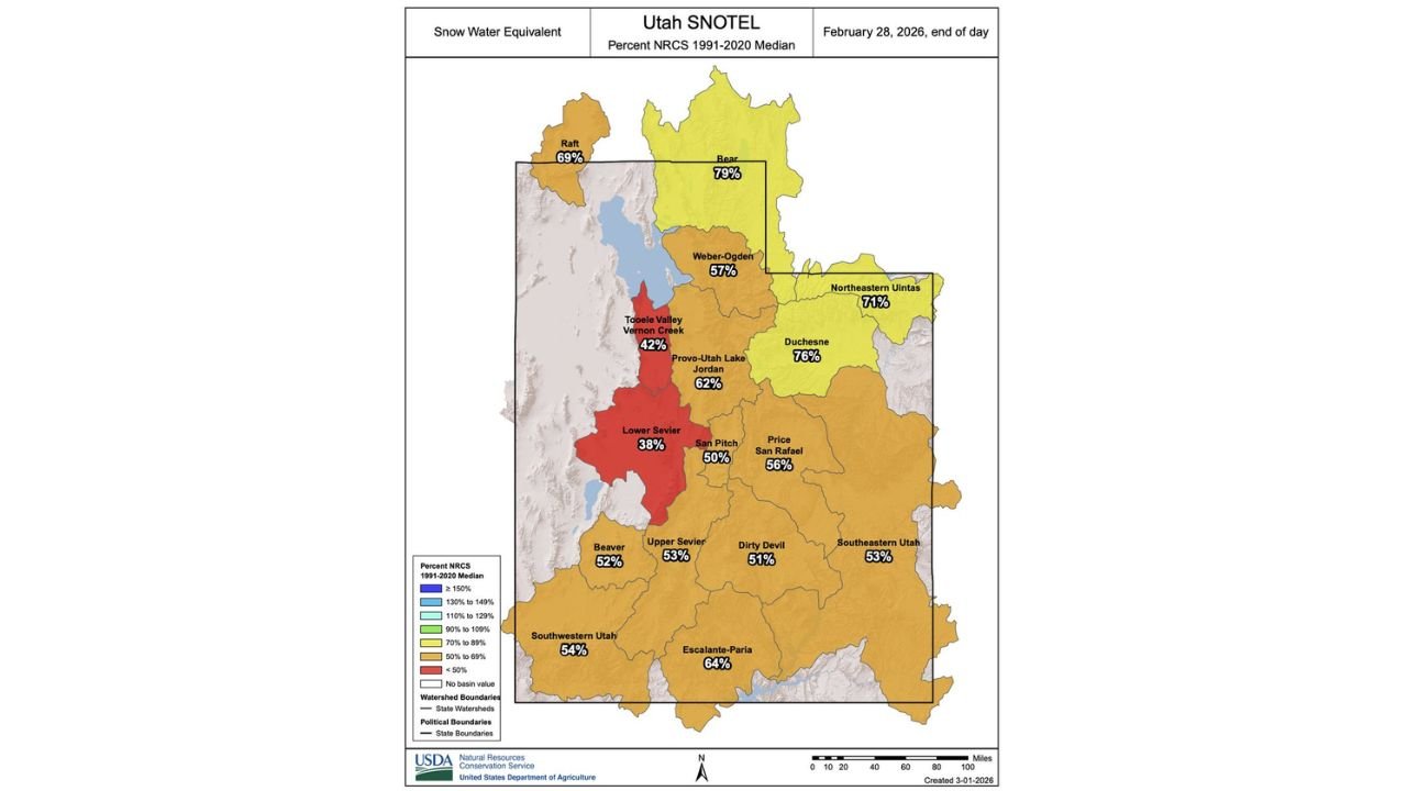
The February 28 Snow Water Equivalent (SWE) map shows widespread deficits, with several basins sitting below 60% of the 1991–2020 median, and some areas dropping into the 30–40% range.
Northern Utah Basins: Mixed but Still Below Normal
Northern Utah is showing some of the strongest numbers statewide, but even here totals remain below the seasonal median.
The Bear River Basin sits at 79% of normal, while the Raft Basin reports 69%. The Northeastern Uinta Mountains are at 71%, and the Duchesne Basin stands at 76%.
While these numbers are not catastrophic, they are still well short of 100% median for this time of year. Entering March — typically a critical accumulation period — these basins will need consistent snowfall to avoid deeper seasonal deficits.
Wasatch Front and Central Utah: Noticeable Shortfalls
Conditions deteriorate more sharply across the Wasatch Front and surrounding regions.
The Weber-Ogden Basin is at 57%, while Provo–Utah Lake–Jordan sits at 62%. These values suggest limited mid-elevation snowpack, particularly below major ski terrain and upper watershed elevations.
More concerning are the western and central valleys. The Tooele Valley–Vernon Creek Basin stands at just 42%, and the Lower Sevier Basin is at 38%, among the lowest in the state.
These figures indicate that low and mid-elevation snowpack is virtually non-existent in some locations, significantly reducing spring runoff potential if March does not deliver.
Southern and Southeastern Utah: Broad Deficits Continue
Southern Utah basins are largely in the 50–64% range, reflecting widespread but not extreme deficits.
Key basin percentages include:
- San Pitch: 50%
- Upper Sevier: 53%
- Dirty Devil: 51%
- Beaver: 52%
- Southwestern Utah: 54%
- Price–San Rafael: 56%
- Escalante–Paria: 64%
- Southeastern Utah: 53%
These numbers show that much of southern Utah is operating at roughly half to two-thirds of normal snowpack, a level that typically raises concerns for late spring water supply if dry patterns persist.
High Elevations May Prevent a Historic Low
Despite widespread deficits, the data suggests that higher elevations are performing better than mid and low elevations.
Basins such as Bear River (79%), Duchesne (76%), and Northeastern Uintas (71%) indicate that upper mountain zones still hold meaningful snow water equivalent.
This higher-elevation snowpack may prevent the 2025–2026 season from being classified among the absolute worst on record. However, without a strong March and April, overall seasonal totals could still rank near the bottom historically.
Why Elevation Matters This Season
The stark difference between higher basins near 70–80% and lower basins near or below 40% underscores a critical pattern this winter:
- Storm tracks likely favored higher terrain
- Warm spells may have limited accumulation at mid elevations
- Snow lines may have fluctuated frequently
When low elevations fail to accumulate snow, spring runoff becomes more dependent on high mountain melt alone — reducing overall watershed efficiency.
Entering March: A Critical Window for Recovery
March is historically one of Utah’s most productive snow months. With many basins currently sitting between 38% and 62% of median, the coming weeks will determine whether the state stabilizes near moderate drought levels or slips into more serious hydrological concerns.
For now, the snowpack picture remains fragile. High elevations are carrying the season, but mid and low elevations are struggling significantly.
If you’re seeing snow conditions in your area or tracking mountain totals as we head into March, share your local updates with CabarrusWeekly.com so we can continue monitoring how this snow season develops.