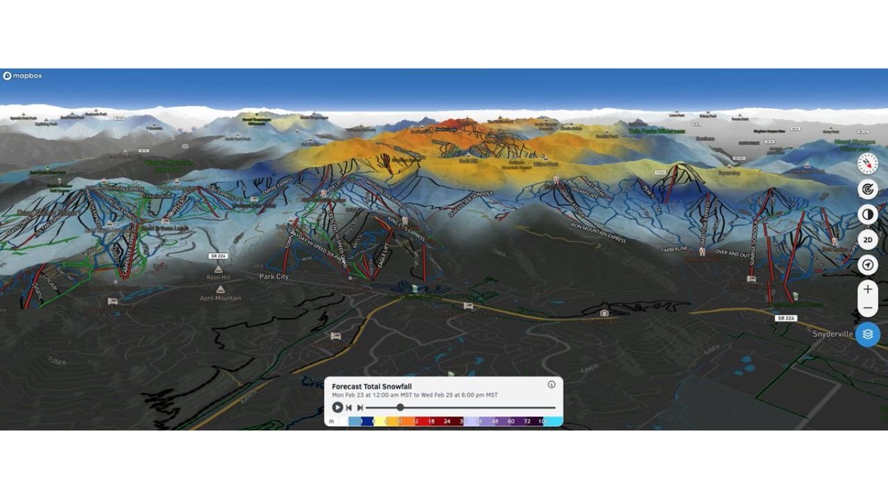
Utah’s Snow Levels Soar to 9,000 Feet, Leaving Park City’s Lower Slopes Bare While Upper Peaks Pile Up Through Wednesday Evening
UTAH — A warm storm system pushing into the Wasatch is creating a dramatic elevation divide in snowfall totals around Park City, with high snow levels keeping lower mountain terrain nearly snow-free while upper peaks collect measurable accumulation through Wednesday evening.
Forecast projections through 6:00 PM Wednesday show snow levels rising to around 9,000 feet, significantly limiting snow at base elevations.
Lower Park City Seeing Little to No Snow
Because snow levels remain elevated, much of the lower mountain near Park City proper, including areas around SR-224 and the base terrain near town, is expected to see little to no snow accumulation.
Temperatures at lower elevations are simply too warm to support consistent snowfall, leading to either rain or very limited slushy buildup.
This includes base areas near:
Park City Mountain Resort
April Mountain vicinity
Lower terrain toward Snyderville
Higher Elevations Picking Up Decent Accumulations
While lower slopes struggle, higher terrain well above 9,000 feet is a different story.
Forecast snowfall maps indicate better totals across:
Upper ridgelines above Park City Mountain
High terrain toward Deer Valley
Elevated areas along the Wasatch back
The graphic projection shows more consistent accumulation bands across the upper mountain zones, where colder temperatures support snow rather than rain.
Why Snow Levels Matter
When snow levels climb toward 9,000 feet:
Lower lifts and base villages often see rain or a rain/snow mix
Mid-mountain terrain becomes inconsistent
Upper bowls and high ridges collect the bulk of storm totals
That’s exactly the setup unfolding in Park City through Wednesday evening.
Storm Timing Through 6 PM Wednesday
Snowfall projections cover the period from early Monday through 6 PM Wednesday, with the bulk of higher-elevation accumulation occurring during peak moisture periods.
However, the warm profile keeps lower elevations marginal.
This creates a “top-heavy” snow distribution — decent totals up high, minimal impact down low.
What This Means for Travelers and Skiers
Visitors heading to Park City should be aware:
Base conditions may remain wet or slushy
Upper mountain skiing will likely offer the best conditions
Snow totals will vary dramatically by elevation
Drivers in and around Park City should also anticipate variable road conditions depending on elevation, especially along higher passes.
Cabarrus Weekly will continue monitoring major weather developments nationwide. If you are in Park City or the Wasatch region experiencing the elevation-driven snow divide, share your conditions with us at CabarrusWeekly.com.