Valentine’s Day Weekend Storm Signal Emerges for the Southeast, With North Carolina in a Wider Watch Zone
CABARRUS COUNTY, NORTH CAROLINA — Early, extended-range guidance is hinting at a small uptick in severe weather potential across parts of the Southeast around Valentine’s Day weekend (Feb. 13–14). This is not a confirmed outbreak or a locked-in forecast, but it is a pattern worth watching as we get closer.
What the new maps are signaling for Feb. 13–14
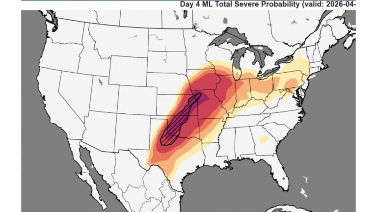
The data provided shows machine-learning total severe probability for two time windows: Day 11 (valid Friday, Feb. 13) and Day 12 (valid Saturday, Feb. 14).
On Feb. 13, the higher probabilities are centered farther west, covering a broad swath from portions of east Texas and Louisiana through Mississippi and Alabama, extending north and east into parts of the Tennessee Valley and nearby states. North Carolina sits closer to the eastern fringe of this signal, where probabilities appear lower but still within the broader “in play” region.
By Feb. 14, the shaded area expands and shifts, covering more of the Deep South into Georgia and the Carolinas, which is when North Carolina looks more meaningfully included in the broader risk envelope. The strongest signal still appears focused to our west and southwest, but the important local takeaway is this: the Carolinas are not completely outside the early severe-weather window in the Day 12 view.
What this could mean for Cabarrus County if the pattern holds
For Cabarrus County, the current signal doesn’t guarantee severe storms, and the exact storm corridor can still shift by hundreds of miles this far out. But the maps do suggest a setup where the Southeast could see organized thunderstorms somewhere in the region, and if the track nudges east, that raises the chance of impactful weather reaching the Piedmont.
If the environment comes together, the main concerns in a February severe setup typically include damaging wind gusts, isolated tornado potential, and heavy downpours along or ahead of a strong cold front. Whether Cabarrus County ends up dealing with stronger storms would depend on small-but-critical details like how quickly warm, humid air returns, where the surface low tracks, and the timing of the front and strongest winds aloft.
Why the signal changes from Friday to Saturday
The Day 11 to Day 12 shift is a common clue in extended-range outlooks: Friday’s signal is broader and more west-focused, while Saturday’s signal spreads farther east into the Southeast and nearer to the Carolinas.
That kind of expansion can happen when a developing storm system is projected to strengthen, pull Gulf moisture northward, and increase atmospheric wind shear across a wider area. It can also happen simply because models are still adjusting to the track and timing, which is why the responsible approach right now is to treat this as a “heads up” window, not a final call.
What to watch over the next week
The next set of updates that matter most for Cabarrus County will be whether the better ingredients line up closer to North Carolina:
A key shift would be signs of stronger Gulf moisture reaching into Georgia and the Carolinas, plus a sharper boundary (front) and stronger upper-level winds arriving during peak heating or early evening. If those pieces trend together, the severe risk would become more realistic locally.
For readers who like to follow official storm outlooks as the dates approach, the Storm Prediction Center will be the best place to watch for updated severe thunderstorm and tornado probabilities once we get into the shorter-range forecast window. For practical reminders on what to do when warnings are issued, the National Weather Service severe weather safety guidance is also worth reviewing before the weekend arrives.
Bottom line for now
Right now, the signal is best described as a small, early-season nudge upward in severe weather potential somewhere in the Southeast around Feb. 13–14, with North Carolina closer to the edge Friday and more included Saturday. The most likely outcome may still be that the highest impacts stay west of Cabarrus County—but the pattern is active enough that it’s smart to keep an eye on updates.
If you notice unusual warmth, increasing winds, or rapidly changing conditions as we approach Valentine’s Day weekend, share what you’re seeing in your part of Cabarrus County. Your local reports help the community track real-time changes—join the conversation at CabarrusWeekly.com.