Valentine’s Day Weekend Winter Storm Signal Re-Emerges as Multiple Snow Events Line Up Across the Northeast and Mid-Atlantic
UNITED STATES — A busy winter pattern is setting up across the Northeast and Mid-Atlantic, with multiple snow chances unfolding over the coming days and renewed signals pointing toward a potentially larger storm around Valentine’s Day weekend.
Snow Event Expected Within the Next 24 Hours
The first system arrives quickly, with widespread snowfall expected as early as tomorrow across portions of the Northeast. Model guidance supports a general 1–3 inch snowfall, with localized areas capable of reaching 2–4 inches, particularly where mesoscale banding becomes established.
This event is expected to be fairly uniform in coverage, though brief periods of heavier snow could push totals higher in isolated spots where lift strengthens along the frontal boundary.
Additional Light Snow Chances Midweek
Behind the initial snowfall, attention turns to Tuesday night into Wednesday, when another weak disturbance may produce light snow accumulations across the same general region. While impacts from this second round appear limited at this time, it reinforces an active and persistent winter pattern rather than a brief cold snap.
There is also conditional potential for another light snow event late in the week, possibly Friday, depending on how upstream energy evolves.
European Model Revives Valentine’s Day Weekend Storm Threat
The most notable development in the latest guidance is the return of a stronger winter storm signal on the European model for Valentine’s Day weekend. The newest runs depict a more organized system taking shape by late Saturday into Sunday, with sufficient moisture and cold air in place for a plowable snowfall scenario in parts of the Mid-Atlantic and Northeast.
While this signal is still several days out, its reappearance after earlier disappearance raises confidence that the pattern may support a more impactful event rather than just scattered light snow.
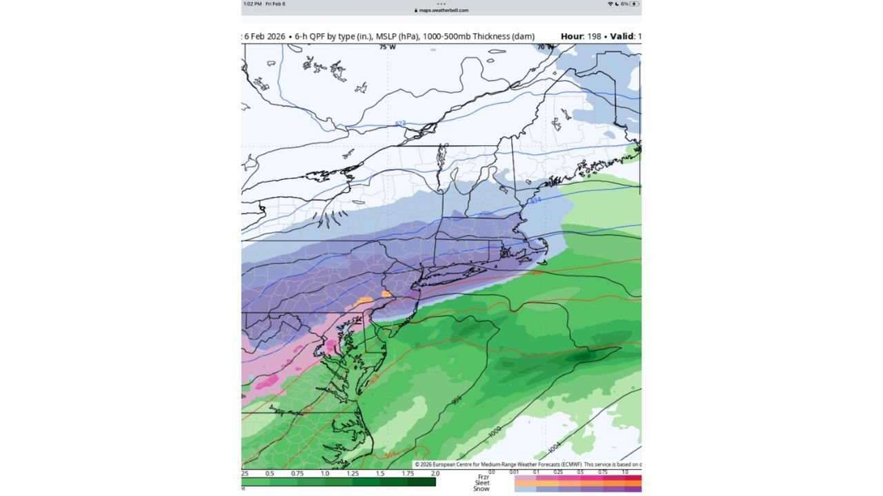
Saturday Morning Setup Shows Wintry Potential
Forecast maps focusing on Saturday late morning highlight a classic cold-overrunning setup, with precipitation expanding northward into colder air. This configuration supports snow or mixed precipitation inland, while warmer air remains suppressed offshore.
The evolution of this system will determine whether snowfall remains moderate or escalates into a high-impact winter storm, particularly for interior and higher-elevation locations.
Forecast Confidence and What to Watch Next
Confidence is high in near-term snowfall through midweek, while moderate but increasing confidence exists for a more significant Valentine’s Day weekend system. Key factors to monitor include the storm track, thermal profiles, and timing of shortwave energy, all of which will become clearer in upcoming model cycles.
Residents across the Northeast and Mid-Atlantic should remain alert for forecast upgrades and accumulating snow potential as the pattern continues to evolve.
If you’re seeing snow, slick roads, or changing conditions where you live, share your experience with us and stay connected with CabarrusWeekly.com for continued winter weather updates.