Virginia and Maryland Temperature Divide: 70s Surge Across Virginia While Baltimore Stays in the 40s as Backdoor Front Threatens Early March Warm-Up
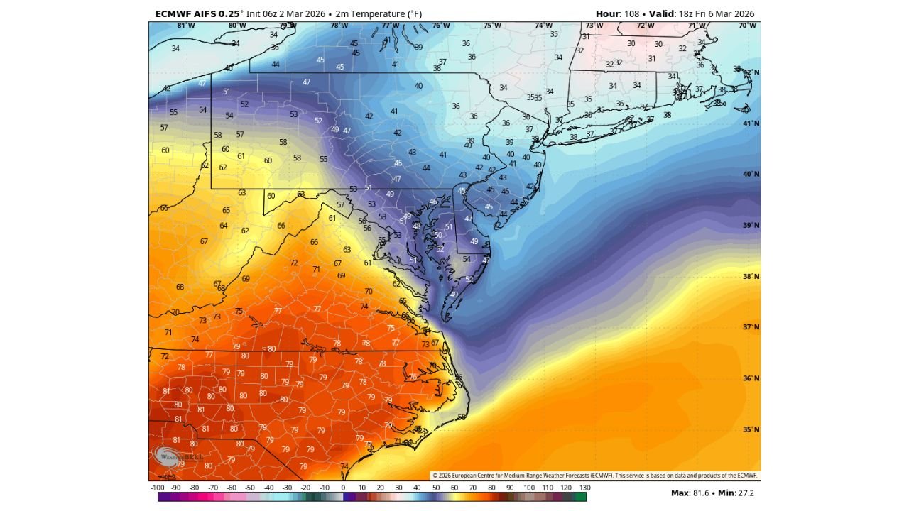
VIRGINIA — A dramatic temperature contrast is setting up for Friday, March 6, as early March teeters between winter chill and spring warmth, with 70s projected across much of Virginia while Maryland, including Baltimore, remains stuck in the 40s and low 50s.
Forecast guidance highlights a classic backdoor cold front scenario, where cooler air presses southwestward from the Mid-Atlantic coast while significantly warmer air surges north through Virginia and the Carolinas.
Sharp Temperature Gradient from Virginia to Maryland
The projected Friday afternoon temperatures show a striking divide:
Across central and southern Virginia, including areas near Richmond and southward toward the North Carolina border, highs are forecast to reach the mid to upper 70s, with some locations approaching 80 degrees.
Meanwhile, just to the north in Maryland, temperatures drop sharply. Baltimore is forecast in the 40s to low 50s, and much of northern Maryland remains entrenched in cooler air.
This creates a temperature difference of 20 to 30 degrees over a relatively short distance, a hallmark of backdoor front setups in early spring.
Pennsylvania and the Northeast Remain Cool
The cooler air mass extends beyond Maryland into:
Pennsylvania, where highs are largely in the 40s
New Jersey, where temperatures hover in the upper 30s to low 40s
New York and southern New England, where readings stay in the 30s
The colder dome remains firmly in place across the northern Mid-Atlantic and Northeast, limiting any northward expansion of the warm surge.
North Carolina Joins the Warm Sector
To the south of Virginia, North Carolina is positioned solidly in the warmer air mass.
Forecast highs across much of North Carolina are projected in the mid to upper 70s, with portions of southern North Carolina potentially nearing 80 degrees.
This places the strongest warmth across:
Southern Virginia
North Carolina
Parts of southern West Virginia
The gradient tightens rapidly moving north toward Maryland.
The Backdoor Front Question
The critical uncertainty centers on how far south and west the cooler marine-influenced air advances.
Backdoor fronts are known for sliding southwestward from the Atlantic, often undercutting warmer air and dramatically lowering temperatures in coastal and Mid-Atlantic locations.
If the front pushes farther south than currently projected:
Parts of northern Virginia could cool significantly
The 70-degree warmth could be trimmed back
Baltimore could remain locked in the 40s all day
If the front stalls farther north, warmer air could briefly push deeper into northern Virginia.
Early March: A Seasonal Battleground
Early March is notorious for sharp temperature battles between lingering winter air and surging spring warmth.
The forecast map illustrates this seasonal tug-of-war clearly:
Upper 70s across Virginia and North Carolina
40s across Maryland and Pennsylvania
30s across New York and New England
Such tight gradients can also enhance cloud cover and coastal breezes near the frontal boundary.
What to Watch Moving Forward
Friday’s temperature outcome will depend heavily on the precise placement of the boundary.
Residents across Virginia, Maryland, North Carolina, Pennsylvania, and New Jersey should monitor updated forecasts, as even small shifts in the front’s position could result in significant temperature adjustments.
The early March pattern remains volatile, and additional forecast refinements are expected as the week progresses.
If you are experiencing this sharp temperature divide where you live, share your local readings with CabarrusWeekly.com so we can continue tracking how this winter-to-spring battle unfolds across the Mid-Atlantic.