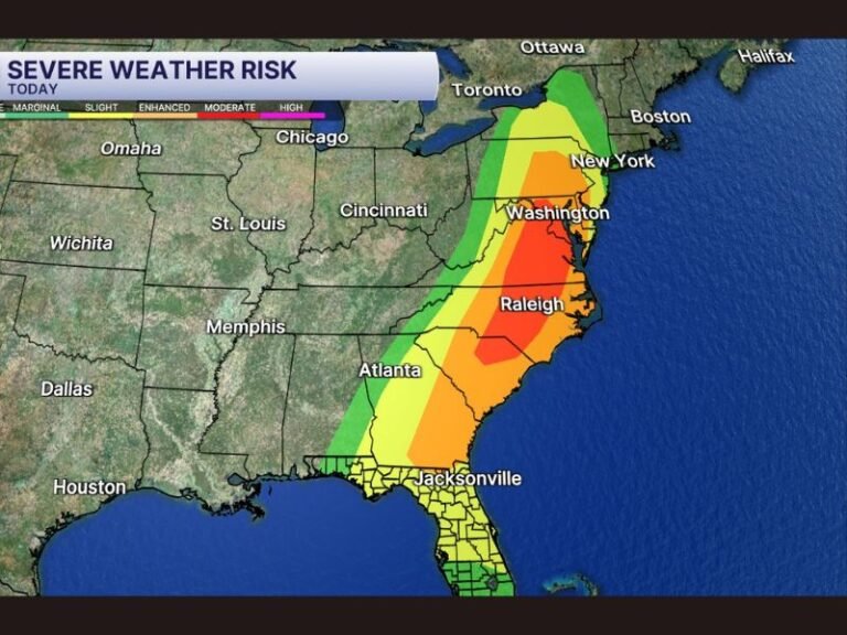
Virginia, Maryland, and Washington DC Prepare for Two Rounds of Severe Storms Monday With Tornado Risk First and 75 MPH Squall Line Later
MID-ATLANTIC — A dangerous severe weather setup could bring two separate rounds of storms across Virginia, Maryland, and the Washington DC region on Monday, with forecasters warning that the first wave may include tornado-producing supercells, followed later by a fast-moving squall line capable of producing widespread damaging winds up to 75 mph.
Meteorologists say residents across the DMV region — including Washington DC, northern Virginia, and central Maryland — should prepare for rapidly changing conditions throughout the day Monday as storms move through the area in multiple phases.
Round One Could Bring Tornado-Producing Supercells Late Morning
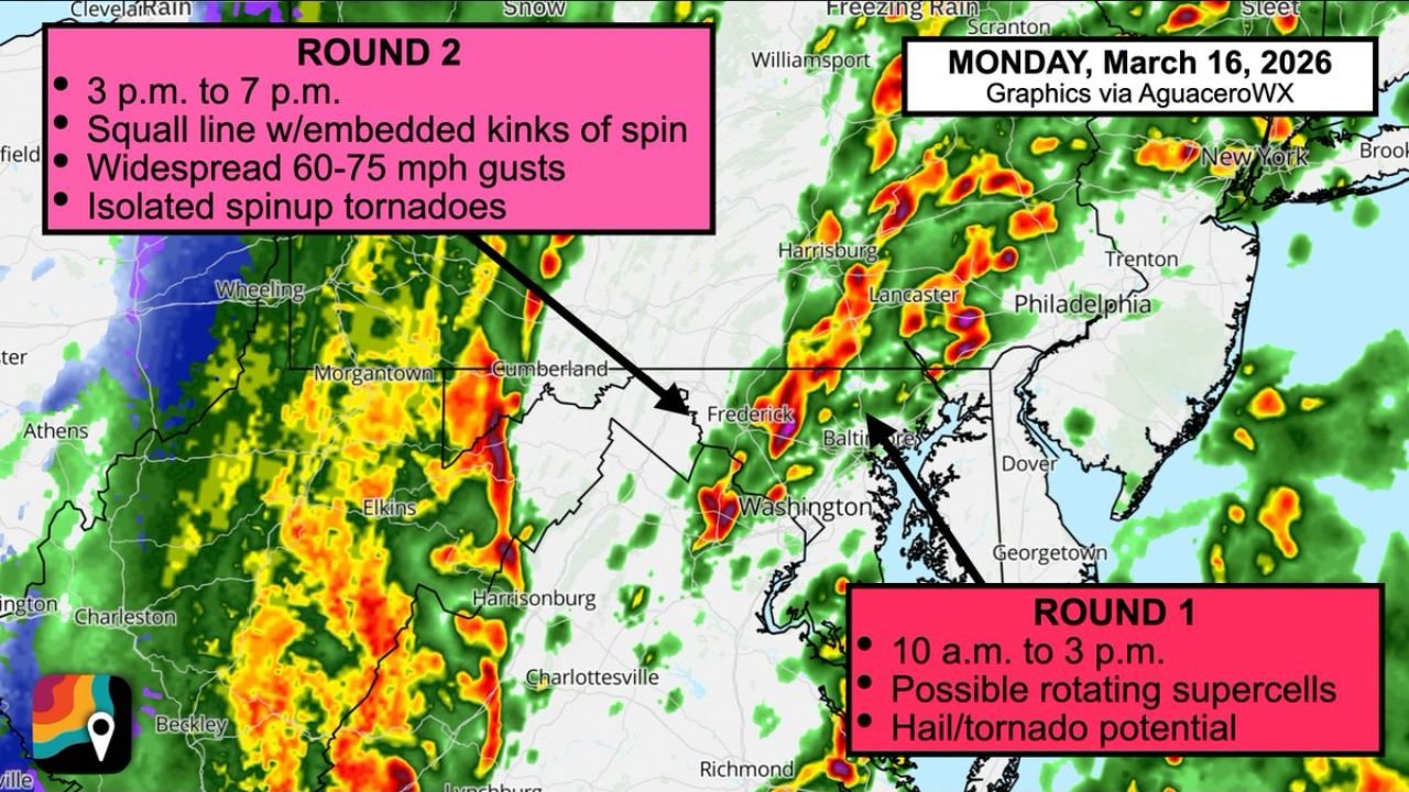
The first round of storms is expected to develop between roughly 10 a.m. and 3 p.m. Monday, when atmospheric conditions may support rotating thunderstorms ahead of the main storm line.
During this period, storms could become isolated supercells, a type of thunderstorm known for producing large hail, strong winds, and tornadoes.
Forecasters indicate that parts of northern Virginia, central Maryland, and the Washington DC metro area could experience these storms as they track northeast through the region.
Because supercells often develop quickly, meteorologists say a few storms during this early phase could briefly rotate and produce tornadoes before merging into a larger storm complex later in the day.
Round Two Expected With Fast-Moving Squall Line
The second and potentially more widespread round of severe weather is expected between approximately 3 p.m. and 7 p.m. Monday, when a powerful squall line sweeps across the region from west to east.
This line of storms is forecast to bring widespread straight-line wind gusts between 60 and 75 mph, capable of causing tree damage, downing power lines, and producing scattered power outages.
Meteorologists say the squall line may also contain embedded rotations along the leading edge, which can occasionally produce brief spin-up tornadoes.
Because the storm line is expected to move quickly, communities across the Mid-Atlantic may experience a sudden burst of intense wind and heavy rainfall as the storms pass through.
Storms Will Track From the Appalachians Toward the Coast
Radar projections suggest storms will first organize across the Appalachian Mountains and West Virginia, then move east into Virginia and Maryland before reaching the Chesapeake Bay and coastal areas.
Cities including Washington DC, Baltimore, Frederick, and surrounding communities fall within the corridor where the strongest storms could pass during the afternoon hours.
Farther north, storms may continue into Pennsylvania and New Jersey as the system moves toward the Northeast Monday evening.
Residents Should Prepare for Rapidly Changing Conditions
Forecasters emphasize that the combination of two storm rounds increases the overall severe weather risk for the region.
Even if the first round of storms weakens in some areas, the second wave arriving later in the afternoon could still produce damaging winds across a large portion of the Mid-Atlantic.
Meteorologists recommend residents stay alert throughout the day Monday and be ready to respond quickly if warnings are issued.
Having multiple ways to receive weather alerts, including mobile notifications and weather radios, can be especially important when storms develop quickly.
Weather radar projections and severe storm timing graphics referenced in this report were compiled using meteorological briefing materials.
Stay with CabarrusWeekly.com for continuing updates as severe weather moves through the Mid-Atlantic region Monday. If storms impact your area, share your local conditions with the CabarrusWeekly.com community to help others stay informed.