Virginia, Maryland, North Carolina and South Carolina Brace for Level 3 ‘Enhanced’ Severe Storm Risk Monday, With 70+ MPH Winds and Tornado Threat
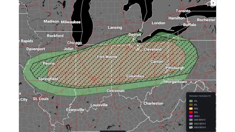
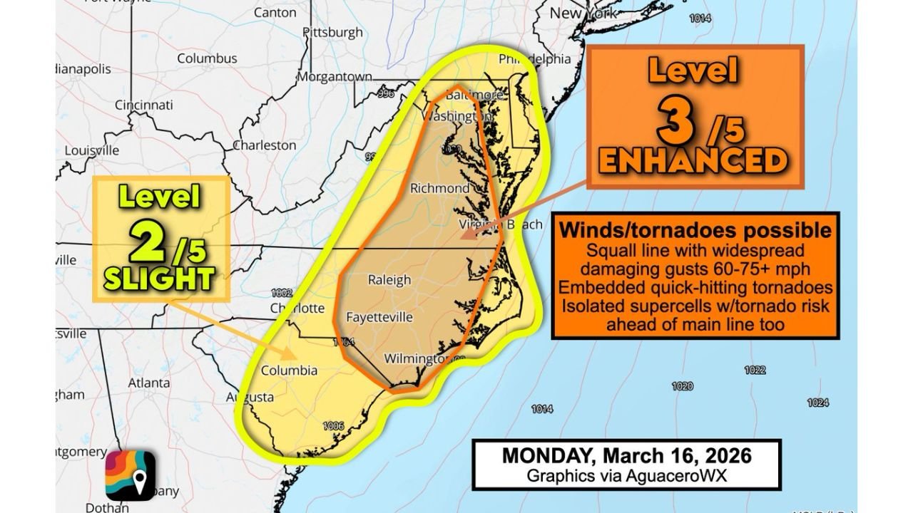
UNITED STATES — A significant severe weather outbreak is increasingly likely across portions of Virginia, Maryland, North Carolina and South Carolina on Monday, March 16, as the Storm Prediction Center has already issued a Level 3 out of 5 “Enhanced” risk — several days in advance, a relatively rare move that signals growing confidence in a high-impact event.
Level 3 Enhanced Risk: Who Is Included?
The Level 3 Enhanced risk zone stretches from eastern South Carolina through eastern and central North Carolina into much of eastern Virginia and parts of Maryland.
Cities in or near the Enhanced risk area include:
- Columbia, South Carolina
- Fayetteville, North Carolina
- Raleigh, North Carolina
- Richmond, Virginia
- Virginia Beach, Virginia
- Washington, D.C. metro
- Baltimore, Maryland
Surrounding this zone is a broader Level 2 “Slight” risk extending farther west into the Carolinas and toward portions of the southern Appalachians.
What’s Driving the Threat?
Forecast discussions point to a powerful jet stream dip swinging overhead Monday, providing intense upper-level wind energy. When combined with warm, unstable air near the surface, that setup can allow thunderstorms to rotate and strengthen quickly.
Confidence is growing in the development of a QLCS — a quasi-linear convective system — essentially a fast-moving squall line capable of producing:
- Widespread damaging straight-line winds of 60–75+ mph
- Embedded, quick-hitting tornadoes
- Brief but intense spin-ups within the line
Additionally, isolated supercells may form ahead of the main squall line. These discrete storms would carry a heightened tornado risk before the primary line even arrives.
Multiple Rounds Possible
Forecasters are signaling the potential for more than one round of storms Monday. That could mean:
- Early isolated or scattered supercells during the afternoon
- A more organized, damaging squall line later in the day or evening
If storms can tap into the strong wind energy aloft, gusts exceeding 70 mph could become numerous in parts of the Enhanced risk area.
Why This Is Noteworthy
Level 3 Enhanced risks are not issued lightly, especially four days in advance. Doing so indicates forecasters see strong agreement among models that ingredients for severe weather will align.
It is not often that the Mid-Atlantic region — including Virginia and Maryland — is highlighted this prominently days ahead of time.
What Residents Should Do Now
Residents across eastern North Carolina, eastern Virginia and southern Maryland should:
- Review severe weather safety plans
- Ensure multiple ways to receive warnings (weather radios, phone alerts)
- Identify safe shelter locations, especially if living in mobile homes
- Stay tuned for updated timing details as Monday approaches
With damaging winds and tornadoes both possible, situational awareness will be critical.
Bottom Line
Virginia, Maryland, North Carolina and South Carolina face a potentially dangerous severe weather setup Monday, March 16. A Level 3 Enhanced risk highlights the possibility of widespread damaging winds and several tornadoes, especially within a fast-moving squall line.
CabarrusWeekly.com will continue monitoring forecast updates and refine timing and impact details as new data becomes available.