Virginia, Maryland, North Carolina and South Carolina Placed Under Rare 30% Severe Risk for Monday as Damaging Winds and Tornadoes Loom
UNITED STATES — A significant escalation in the severe weather forecast has been issued for parts of the Mid-Atlantic and Carolinas, as the Storm Prediction Center (SPC) has introduced a 30% severe weather risk for Monday, March 16.
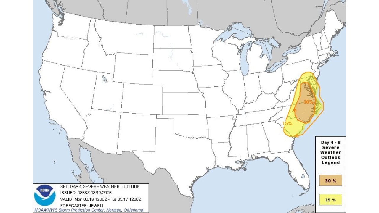
That 30% area — highlighted in the SPC’s Day 4 outlook — signals a growing confidence in widespread severe storms capable of producing significant damaging winds and a few tornadoes.
Where the 30% Risk Is Centered
The 30% severe probability zone stretches across portions of:
- Eastern North Carolina
- Eastern and central Virginia
- Southern Maryland
- Parts of northeastern South Carolina
Cities within or near the higher-risk area include:
- Raleigh, North Carolina
- Richmond, Virginia
- Virginia Beach, Virginia
- Washington, D.C. metro
- Baltimore, Maryland
Surrounding this core 30% zone is a broader 15% severe risk that extends farther into the Carolinas and parts of the Mid-Atlantic.
What a 30% Risk Means
A 30% severe probability in a Day 4 outlook is not routine. It means there is at least a 30% chance of severe weather — including damaging winds of 58+ mph, hail of 1 inch or greater, or tornadoes — within 25 miles of any given point in that shaded area.
More importantly, forecast discussions emphasize the potential for:
- Significant damaging straight-line winds
- A few severe tornadoes
The wording indicates forecasters are concerned not just about isolated storms, but a broader damaging wind event.
Damaging Winds Likely
Confidence is increasing that a strong line of storms could organize and sweep through the region Monday. With powerful upper-level winds expected overhead, thunderstorms may be able to transport destructive gusts down to the surface.
Wind gusts exceeding 70 mph are possible in the most intense segments of the line. Such winds can down trees, damage power lines and create widespread outages.
Tornado Potential
In addition to the wind threat, the environment may support:
- Embedded tornadoes within a fast-moving squall line
- Isolated supercells ahead of the main line capable of producing tornadoes
While the tornado threat may not be widespread, even a few tornadoes in the Mid-Atlantic region can have significant impacts due to population density.
Why This Forecast Stands Out
Day 4 outlooks typically carry lower probabilities due to uncertainty. Introducing a 30% area this far in advance signals that:
- Forecast models are showing strong agreement
- The atmospheric setup appears favorable for organized severe storms
- Confidence is higher than usual at this lead time
It is relatively rare to see a 30% severe risk issued several days ahead for the Mid-Atlantic region.
What Residents Should Do Now
Residents across eastern North Carolina, Virginia and southern Maryland should begin preparing by:
- Reviewing severe weather safety plans
- Ensuring multiple ways to receive warnings
- Monitoring forecast updates through the weekend
- Being ready to adjust plans Monday if watches or warnings are issued
Bottom Line
Parts of Virginia, Maryland, North Carolina and South Carolina are now under a 30% severe weather risk for Monday, March 16 — a strong signal that significant damaging winds and a few tornadoes are possible.
CabarrusWeekly.com will continue tracking this developing severe weather threat and provide updated timing and impact details as new information becomes available.