Washington, D.C. Endures Coldest Meteorological Winter Since 2002–03 as Eastern U.S. Emerges as Hemisphere’s Notable Cold Spot
WASHINGTON, D.C. — Through Monday, the nation’s capital is experiencing its coldest meteorological winter to date since the 2002–03 season, with average temperatures running roughly 5 degrees below normal.
Eastern U.S. Stands Out as Cold Spot in the Hemisphere
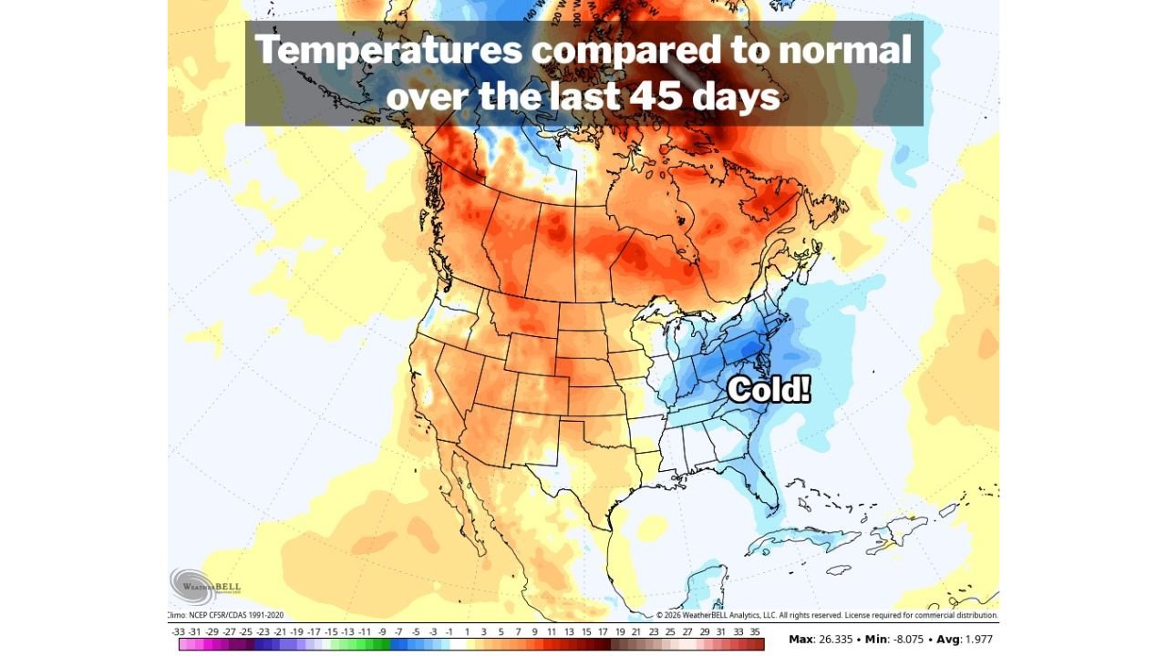
Temperature anomaly data from the past 45 days shows a pronounced pocket of below-normal readings centered over the Mid-Atlantic and parts of the Southeast, including Virginia, Maryland, North Carolina, South Carolina, and Georgia.
While much of western and central North America has trended warmer than average, the Eastern United States has consistently remained cooler, creating one of the more notable cold pockets in the Northern Hemisphere this winter.
Washington, D.C.’s average temperature of 34.5 degrees places this winter in rare territory compared to the past two decades.
Coldest DC Winter in Over 20 Years
Meteorological winter spans December through February. With the season nearing its conclusion, D.C.’s current average temperature marks its coldest winter-to-date since 2002–03, underscoring the persistence of below-normal air masses across the region.
The anomaly map highlights deeper blues across the Mid-Atlantic, confirming sustained colder-than-normal conditions relative to the 1991–2020 climate baseline.
Although not record-breaking on an all-time scale, the seasonal departure is significant in the context of recent winters, many of which have trended milder.
Warmer Finish Ahead, Mixed Signals for Early March
Despite the colder season overall, forecasts indicate a warmer-than-normal pattern for the remainder of this week, offering some moderation before winter officially ends.
Looking ahead to next week, guidance suggests a more mixed pattern, with fluctuations between warmer and cooler air masses as meteorological winter transitions toward early spring.
For residents across North Carolina and the broader Mid-Atlantic, the takeaway is clear: while winter has been notably colder than recent years, the pattern may begin loosening its grip as March approaches.
As we close out meteorological winter, let us know how this season compares to recent years in your area. Share your local temperature observations and stay informed with continued updates at CabarrusWeekly.com.