Weak Snow Chance Late Tuesday Into Early Wednesday Could Bring Flurries to a Coating From DC to Baltimore, With Many Areas Getting Nothing
NORTH CAROLINA — A weak winter system being tracked for late Tuesday into early Wednesday is still on the table for the Washington, D.C. region, but the latest guidance points to a very light event—the kind that may produce occasional flurries, a brief steadier light snow, or no accumulation at all depending on where temperatures dip below freezing after dark.
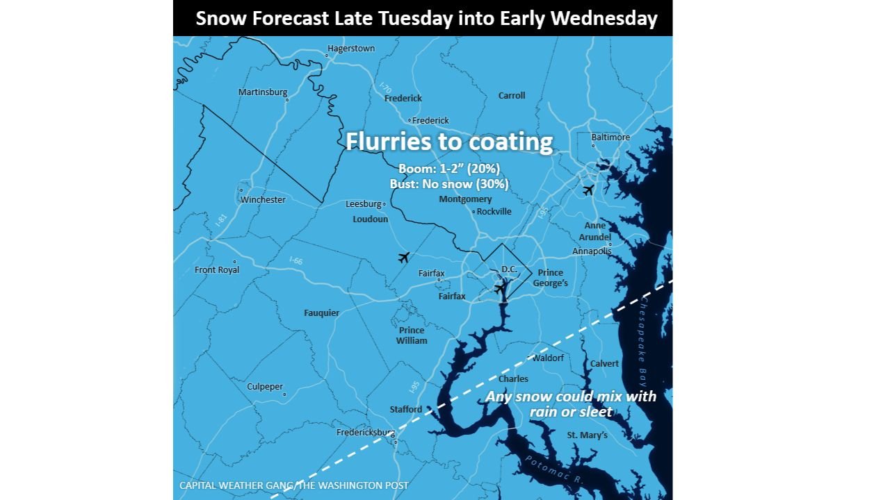
Forecasters say the most realistic outcome is flurries to a coating, with any measurable snow mainly tied to a narrow window Tuesday night when colder air has a better chance of locking in.
The Timing Window Runs From Tuesday Afternoon to Early Wednesday
The current thinking keeps the overall snow window fairly broad, stretching from about 3 p.m. Tuesday to around 4 a.m. Wednesday. That does not mean steady snowfall for 13 hours—rather, it reflects the period when intermittent flurries or light snow showers could occur as the weak system slides through.
The most meaningful travel concern, if it develops, would likely come after dark Tuesday evening, when temperatures fall below freezing and even a small amount of precipitation can begin sticking to colder surfaces.
Most Places Are Looking at Flurries, Not a True Accumulating Snow
Across much of the region—especially around Washington, D.C., Montgomery County, and the northern Virginia suburbs—the expectation is light snow at most, with many areas seeing nothing more than flakes in the air.
The map depiction calls the event “Flurries to coating,” a phrase that typically signals more nuisance than disruption. It’s the type of setup where grass and elevated surfaces can briefly whiten, while road conditions may stay mostly wet—unless temperatures drop fast enough for a quick glaze or light stick on untreated roads.
Dusting to a Half-Inch Is the Most Likely Outcome
If accumulation happens, the most common range being watched is a dusting up to about a half-inch. That’s especially true for areas that cool efficiently Tuesday evening and can maintain freezing temperatures long enough for snow to stick.
The update also notes that the region “could end up with no accumulation,” which remains a very real possibility with a system this weak.
A “Boom” Scenario Exists, But It’s Low Probability
There is still a small ceiling if the system trends stronger between now and Tuesday. In that case, the upper-end potential is described as around 1 to 2 inches—but only if the band organizes better and coincides with colder temperatures.
The probability breakdown shared on the graphic highlights how uncertain and low-end this is:
- Boom (1–2 inches): about 20%
- Bust (no snow): about 30%
In other words, the forecast is leaning toward “something light” but with enough uncertainty that a complete miss is still on the table.
Rain or Sleet Could Mix In Near the Bay and South of DC
Another limiting factor is the potential for mixing near and southeast of the city. The graphic notes that any snow could mix with rain or sleet closer to the water and farther south—areas that include parts of Charles County, Calvert County, and St. Mary’s County, where marginal temperatures often turn light snow into wet mix.
If mixing becomes more dominant, that further lowers the odds of meaningful snow totals, even if flakes start the event.
Why Cabarrus County Readers Should Care About This Setup
Even though this system is centered well north of North Carolina, it’s a good example of how “light snow potential” often plays out in borderline setups: a long time window, small totals, and big neighborhood-to-neighborhood differences based on temperature timing.
For travelers heading toward D.C., Maryland, or northern Virginia, the practical takeaway is simple: watch Tuesday night, not just the daytime forecast. If temperatures drop quickly after sunset, even a dusting can create slick spots on bridges, ramps, and untreated roads.
If you’ve got family or travel plans in the D.C.–Baltimore corridor, tell us what you’re seeing in your area Tuesday evening. Your on-the-ground updates help other readers plan smarter with these low-end, high-uncertainty winter setups.