West-Central Florida Watches Unprecedented Snow Potential as NAM and NOAA Blend Hint at Overnight Gulf Flurries
FLORIDA — A highly unusual winter signal is gaining attention across West-Central Florida, where the latest NAM and NOAA National Blend of Models are showing a low-probability but remarkable chance of snowflakes late Saturday night into early Sunday morning, driven by cold air interacting with Gulf moisture.
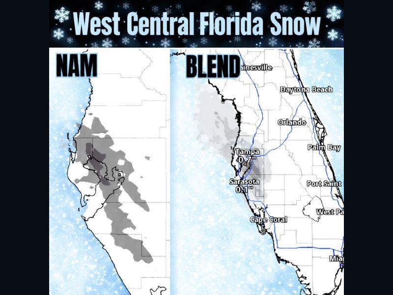
NAM and NOAA Blend Keep the Snow Signal Alive
Updated Thursday evening guidance shows both the NAM and blended NOAA models in agreement on a narrow window for wintry precipitation developing overnight Saturday into early Sunday as cold air filters south and shallow moisture pushes inland from the Gulf.
While confidence in measurable accumulation remains low, the consistency across models is what has forecasters paying attention. In one localized projection, the NAM even depicts up to one inch of snow near Oldsmar, an outcome that would be extraordinary for the region if it were to verify.
Areas Being Closely Watched Across West-Central Florida
The highest focus remains along the Tampa Bay coastline and adjacent inland areas, including Tampa, Oldsmar, Sarasota, and Cape Coral. Blended guidance suggests minor snow or flurry potential near Tampa around 0.7 inches, with lighter amounts near Sarasota, while areas farther inland and south see rapidly decreasing probabilities.
These values should be viewed cautiously, as even slight temperature or moisture changes could result in no accumulation at all.
Why Snow in Florida Is So Rare
Snowfall in Florida requires an exceptionally rare alignment of Arctic-level cold air, sufficient moisture, and the correct atmospheric depth. In most winter cold outbreaks, Florida is either too dry or too warm aloft for snowflakes to survive to the surface.
That is why long-time residents note they have never seen a snow forecast like this in decades, even when confidence remains limited.
Timing Remains Critical
The best window for any snowflakes appears to be late Saturday night through shortly after sunrise Sunday, when surface temperatures are coldest and onshore moisture briefly peaks. If flakes do occur, they would likely be brief, light, and highly localized, with most locations seeing nothing more than cold air.
What Impacts Are Expected
Even if snowflakes appear, no widespread impacts are expected. Roads will remain unaffected, and any flakes would melt quickly after sunrise. The greater concern for Florida residents will continue to be unusually cold temperatures, with frost and freeze impacts far more likely than snow accumulation.
What Happens Next
Forecasters will continue watching whether the cold air deepens enough to support flakes reaching the ground. Confidence remains low, but the fact that multiple models are holding onto the idea makes this a setup worth monitoring.
If you’re in West-Central Florida and notice flurries, ice crystals, or unusually cold overnight conditions, share what you’re seeing. Stay with CabarrusWeekly.com for continued updates, analysis, and coverage of this rare Florida winter setup.