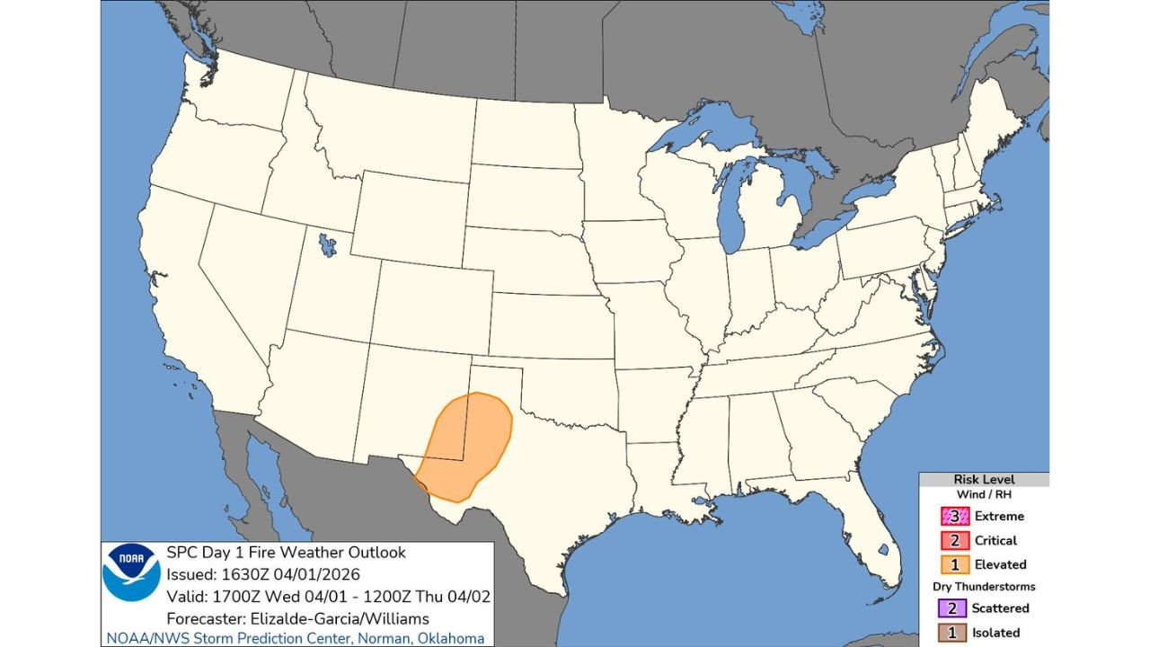
West Texas and Southeast New Mexico Face Elevated Fire Weather Risk Wednesday Through Thursday as Wind and Low Humidity Combine Across the Pecos, Midland, Odessa, and Carlsbad Corridor
UNITED STATES — The Storm Prediction Center has issued an Elevated Fire Weather Risk across a focused zone covering far west Texas and southeastern New Mexico for Wednesday, April 1 through Thursday morning, April 2, 2026. The combination of low relative humidity and gusty winds across the Pecos, Midland, Odessa, and Carlsbad corridor creates conditions where any fire that starts can spread faster than normal — and where outdoor burning should be avoided through the outlook period.
This outlook was issued by the NOAA/NWS Storm Prediction Center at 1630Z on April 1, 2026, valid through 1200Z Thursday, April 2.
What Elevated Fire Weather Means
An Elevated Fire Weather Risk sits one level below Critical on the SPC fire weather scale. It is issued when wind speeds and low humidity values combine to create an environment where fires can develop and spread more readily than on a typical day — but have not yet reached the threshold of Critical or Extreme conditions where rapid and uncontrollable fire spread is considered likely.
For west Texas and southeast New Mexico, the Elevated designation reflects a dry and breezy pattern moving through the region Wednesday afternoon and persisting into Thursday morning. Vegetation across this part of the country is already in a vulnerable state following the record-breaking March heat that left the Southwest significantly drier than normal heading into spring.
Why West Texas and New Mexico Are Vulnerable Right Now
The fire weather risk across west Texas and southeast New Mexico does not exist in isolation. It is the product of a landscape that has been progressively drying out through one of the warmest and driest Marches on record across the Southwest.
Following March 2026’s historic 7-degree above-average temperatures across the region, the combination of early vegetation green-up followed by accelerated drying has left the grass, brush, and rangeland across this corridor in a state of elevated fuel receptivity — meaning ignition is easier and fire spread is faster than it would be under normal late-winter moisture conditions.
When even modest wind and low humidity arrive in this environment — as they are today — the fire weather risk escalates beyond what the raw wind and humidity numbers alone would suggest. The fuel is primed. The atmospheric conditions are providing the trigger.
Affected Area — Wednesday Through Thursday Morning
| Area | Risk Level |
|---|---|
| Far West Texas — Pecos, Midland, Odessa corridor | Elevated |
| Southeastern New Mexico — Carlsbad, Roswell area | Elevated |
Forecast Confidence Level
High confidence on Elevated fire weather conditions across west Texas and southeast New Mexico through Thursday morning — the wind and humidity combination is well-established and consistent with forecast data.
High confidence on the geographic focus area** — the Elevated zone is clearly defined and reflects the overlap of the driest air and strongest wind values across the region.
What West Texas and Southeast New Mexico Residents Must Do
Avoid all outdoor burning through Thursday morning. Even under Elevated conditions, a fire that escapes control in the current fuel environment can spread faster than expected. No burn is worth the risk.
Be cautious with any spark-producing activities outdoors — equipment operation, vehicle use in dry grass, and any other ignition sources carry elevated risk across the Pecos, Midland, Odessa, and Carlsbad area through Thursday.
If you see smoke, call 911 immediately. Early reporting is the single most effective tool for keeping a fire small before wind and dry conditions allow it to grow.
The Bottom Line
Far west Texas and southeast New Mexico are under an Elevated Fire Weather Risk through Thursday morning as wind and low humidity combine across the Pecos, Midland, Odessa, and Carlsbad corridor. Following March 2026’s record-breaking heat and drought conditions across the Southwest, the landscape is primed for faster-than-normal fire spread under even modest fire weather conditions. Avoid outdoor burning and stay alert through Thursday morning.
Stay ahead of fire weather and dangerous conditions before they arrive. Visit cabarrusweekly.com for daily fire weather alerts, severe weather coverage, and storm updates from across the United States — because knowing early is the difference that matters.