Western Storm Track Looks Ready to Reboot Next Week, Signaling a Multi-Storm Pattern as a Major Upper Low Forms Over the Rockies
NORTH CAROLINA — Confidence is growing in the longer-range pattern that storms could return to the western United States starting next week, and the key detail in the latest signal is that it may not be a one-time hit. The setup being highlighted points to a series of storms—a more active stretch where one system is followed by another as the atmosphere reloads.
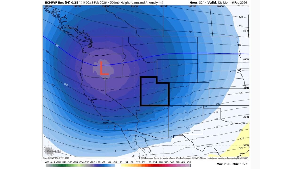
The Big Signal Is a Strong “Low” Over the Western U.S.
The forecast map shows a pronounced “L” centered over the interior West, a classic indicator of a deeper upper-level trough/low that can act like a storm factory. When a feature like this sets up and holds, it often supports repeated rounds of wind, mountain snow, valley rain, and travel disruptions across multiple states rather than a single quick system.
This is not a surface forecast map showing exact snowfall totals or specific cities. Instead, it’s a large-scale pattern snapshot—the kind forecasters use to identify whether the West is trending toward stormy and unsettled versus quiet and dry.
Timing Points to Mid-February, Not an Immediate Change
The model panel shown is labeled as an ECMWF ensemble output with a valid time of 12z Monday, February 16, 2026, placing this signal in the mid-February window. That’s far enough out that details will evolve, but the growing confidence message is about the pattern itself: the atmosphere may be lining up for a return of active weather out West.
Why This Looks Like “Multiple Storms,” Not a One-Off
The language attached to the data emphasizes that the potential is there for a series of storms. That typically happens when:
- A persistent trough anchors over the West
- The jet stream stays energized and keeps delivering new impulses
- The storm track favors repeated systems rolling through the same general corridor
If the trough remains in place for several days, the West can see a cycle of waves of precipitation, sometimes with only short breaks between them.
What This Means for Cabarrus County Readers Watching the National Pattern
Even though this particular signal focuses on the West, it matters for the rest of the country—including North Carolina—because the U.S. weather pattern is connected. When the West turns more active, it can influence how the central and eastern U.S. behaves in the days that follow, depending on how the trough is positioned and whether it eventually pushes east or stays anchored.
For Cabarrus County, the key takeaway right now is not to lock in a local forecast from this map—but to recognize that a pattern shift toward a more stormy West can sometimes be the first step in a broader, downstream change later.
What We’ll Be Watching Next
As this signal gets closer, the most important things to watch will be:
- Whether the western “L” stays strong or weakens
- If the storm track targets the Pacific Northwest, California, the Great Basin, or the central Rockies
- How quickly (or slowly) the pattern tries to progress east into the Plains and beyond
CabarrusWeekly.com will keep an eye on whether this becomes a true multi-storm stretch or fades as newer data arrives. If you have family travel planned to western states next week, this is the kind of early heads-up worth monitoring as forecasts tighten.