Western U.S. Snowpack Falls Well Below Average in Key Regions, Raising Concerns for Early and Active Spring Fire Season
WESTERN UNITED STATES — New snowpack data shows significant shortfalls in snow water equivalent across large portions of the Western United States, signaling growing concern that an early and potentially active spring fire season could develop if additional precipitation does not arrive in the coming weeks.
Snowpack Levels Lag Well Behind Seasonal Normals
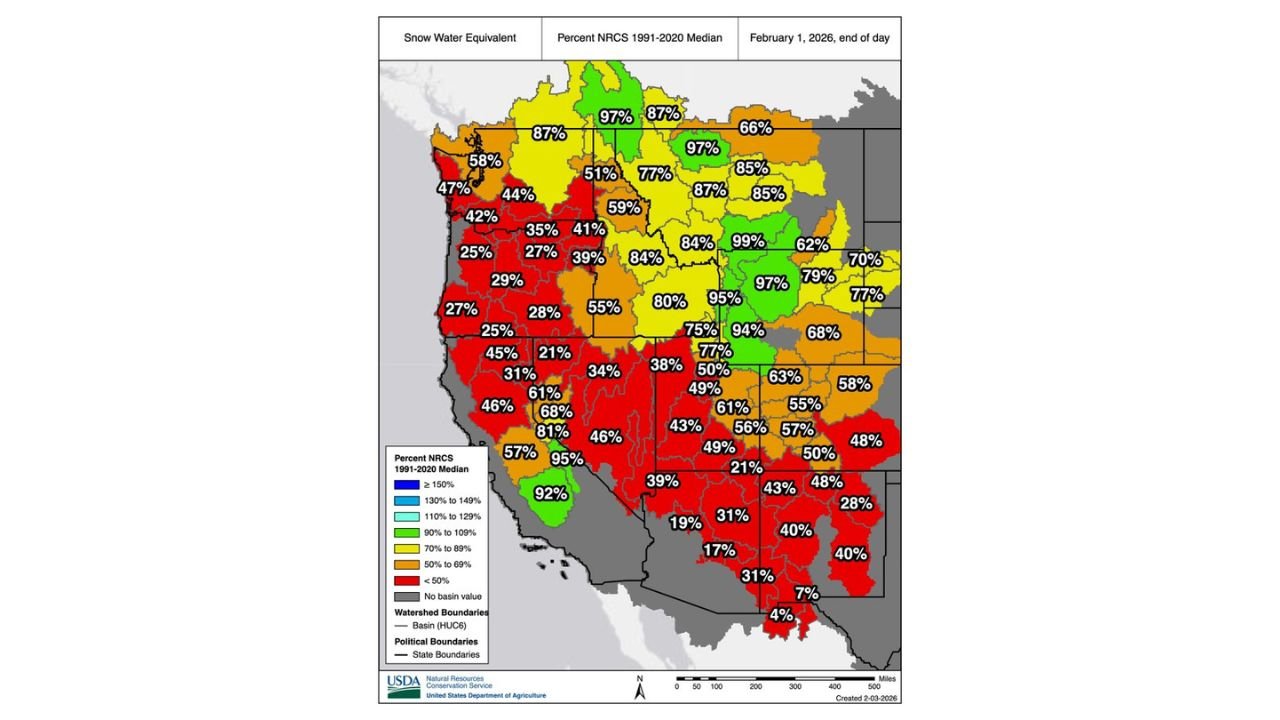
As of February 1, 2026, snow water equivalent measurements compared to the 1991–2020 median reveal that many western basins are running well below average, particularly across the Southwest, California, and parts of the Pacific Northwest. Several regions are currently reporting less than 50 percent of normal snowpack, with some southern areas dipping below 25 percent of average.
These deficits are especially pronounced across Arizona, New Mexico, southern Utah, southern Nevada, and inland California, where mountain snowpack typically plays a crucial role in delaying spring drying.
Northern Rockies Fare Better, but Gaps Remain
Not all regions are struggling equally. Portions of the Northern Rockies and central Rockies, including parts of Montana, Wyoming, and Colorado, are closer to seasonal averages, with some basins near 90 to 100 percent of normal. However, even in these areas, neighboring basins show sharp contrasts, underscoring how uneven the winter pattern has been across the West.
This patchwork snowpack distribution increases the likelihood of early snowmelt in lower-elevation zones, even where higher elevations remain closer to average.
California and the Southwest Face the Most Immediate Risk
California continues to stand out as one of the most vulnerable areas. Many Sierra-adjacent and interior basins are sitting in the 25 to 45 percent of normal range, limiting spring runoff potential. Farther south, Arizona and New Mexico show some of the lowest percentages on the map, with several basins reporting below 20 percent of median snowpack.
Without sustained late-winter storms, these regions could transition rapidly from winter to dry conditions, shortening the window before vegetation begins to cure.
Why Snowpack Matters for Fire Season Timing
Snowpack acts as a natural moisture reservoir, slowly releasing water into soils and streams as temperatures rise. When snowpack is deficient, soils dry faster, vegetation cures earlier, and fire season can begin weeks ahead of schedule.
An early melt also increases the likelihood that spring wind events and warm spells coincide with dry fuels, a combination that historically leads to rapid fire spread.
Precipitation in the Coming Weeks Will Be Critical
Meteorologists stress that late-season storms can still make a meaningful difference, particularly in February and early March. Several strong precipitation events would be needed to meaningfully improve snow water equivalent totals across the most impacted regions.
Absent that moisture, the western U.S. could enter spring with elevated wildfire risk, especially across the Southwest and California.
Residents across the West are encouraged to stay informed as winter progresses and to monitor local water and fire outlooks closely. Share observations from your area and continue following in-depth weather and climate coverage from CabarrusWeekly.com as the season evolves.