Where Is Winter? Massive Warm Surge Covers Nearly the Entire U.S. as Arctic Air Retreats to Canada
UNITED STATES — If you’ve been wondering where winter went, the latest upper-air temperature anomaly map provides a clear answer: it’s largely absent across the Lower 48.
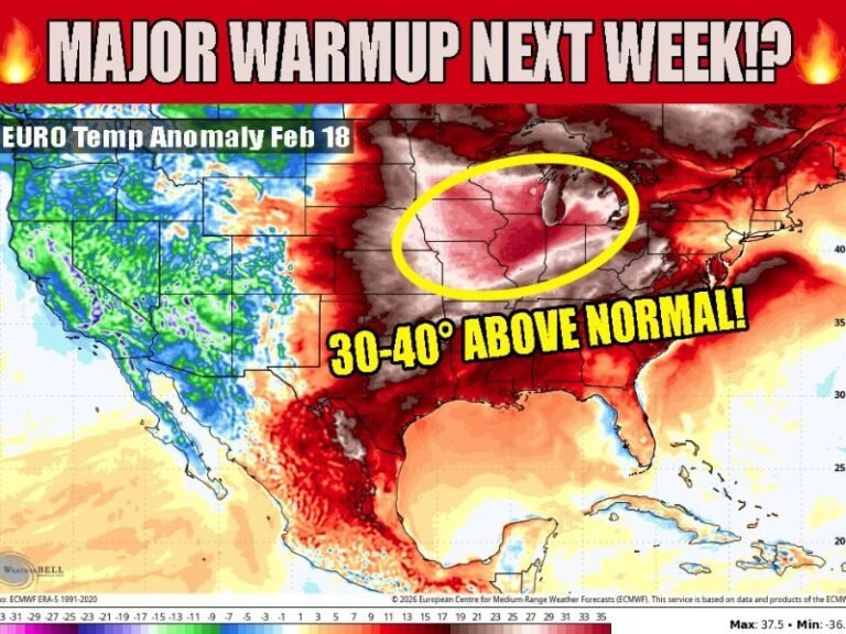
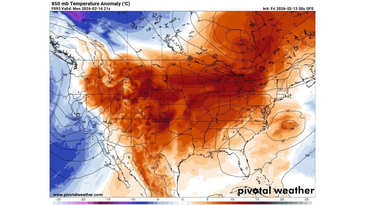
Forecast data valid Monday, February 16 shows widespread positive temperature anomalies at the 850 mb level stretching from the Rockies through the Plains, Midwest, South, and into the Northeast. In simple terms, most of the country is running well above seasonal averages.
Widespread Warmth Dominates the Central and Eastern U.S.
The most intense warm anomalies are centered over:
- The Central Plains
- The Upper Midwest
- The Great Lakes region
- Parts of the Northeast
- Much of the Southern U.S.
Deep red shading across states like Kansas, Nebraska, the Dakotas, Iowa, Minnesota, Wisconsin, Illinois, Missouri, and Michigan indicates temperatures significantly above normal for mid-February.
The warmth extends south through Texas and Oklahoma and eastward into the Ohio Valley and portions of the Mid-Atlantic.
This isn’t just a mild day — it’s a large-scale pattern shift with an expansive ridge dominating much of the country.
The Cold Air Is Trapped in Western Canada
The only notable cold anomalies appear well north of the U.S. border — across parts of western and northwestern Canada.
Blues and purples on the map indicate below-average temperatures confined mainly to:
- Western Canada
- Portions of British Columbia
- Areas north of the northern Rockies
In other words, the true Arctic air mass is displaced far to the north and west, leaving the continental United States largely removed from sustained winter conditions.
Western U.S. Sees More Mixed Signals
Parts of the Pacific Coast and interior West show weaker anomalies compared to the central U.S.
While some cooler pockets appear near the West Coast, they are modest relative to the strong warmth centered over the Plains and Midwest.
The strongest ridge axis appears to be positioned over central North America, allowing warmth to surge northward into southern Canada while suppressing Arctic outbreaks into the Lower 48.
What This Means for Mid-February
For mid-February, this pattern represents a notable departure from typical winter behavior.
At this time of year, strong Arctic intrusions frequently dive south into the Plains, Midwest, and East. Instead, the atmospheric setup is favoring:
- Expanded mild air masses
- Reduced Arctic penetration
- A shrinking winter footprint across the U.S.
When upper-level temperatures run significantly above normal at 850 mb, that warmth often translates to milder surface highs, reduced snowpack persistence, and limited opportunity for widespread winter storms in affected regions.
The Big Picture
The map tells a simple story: winter air is largely displaced north of the U.S., while a broad warm pattern dominates most of the country.
With above-average temperatures covering such a large area, sustained Arctic outbreaks appear unlikely in the near term under this setup.
For now, the answer to “Where is winter?” appears to be — mostly in Canada.
For continued national pattern updates and regional weather impacts, stay with CabarrusWeekly.com.