Widespread Warm Pattern to Cover Southeast, Mid-Atlantic, Midwest and Northeast Feb. 18–24 With 50–60% Above-Normal Odds
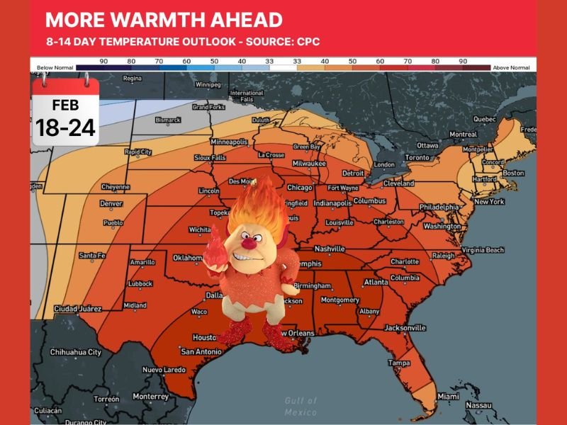
UNITED STATES — A broad late-February warm signal is expanding across much of the eastern half of the country, with official 8–14 day guidance indicating a 50–60% probability of above-average temperatures between February 18 and February 24.
Southeast States Included in the Warmer Zone
The outlook shading clearly covers the Southeast, including North Carolina, South Carolina, Georgia, Alabama, Mississippi, Florida, Tennessee, and Kentucky. These states fall within the warmer-colored probability zone, signaling a higher likelihood of temperatures averaging above seasonal norms during the period.
This is not a localized warm-up, but rather a regional-scale pattern shift.
Mid-Atlantic and Midwest Also Trending Mild
The warm signal extends northward into the Mid-Atlantic, including Virginia, Maryland, and surrounding states, and pushes westward into parts of the Midwest, including Illinois, Indiana, Ohio, Missouri, Iowa, and Kansas.
Cities across these states are positioned within the above-normal probability shading, indicating the warmer pattern is expected to be widespread and not confined to southern latitudes.
Northeast Included in the Above-Average Probability Area
The outlook also highlights portions of the Northeast, including areas near Pennsylvania, New York, and New England, within the warmer-than-normal zone. While probabilities may vary slightly by sub-region, the broader signal supports a multi-state warm tendency across the eastern third of the country.
Early Portion of the Window May Run Even Warmer
The discussion tied to the outlook suggests the earlier part of the Feb. 18–24 period may feature a stronger departure above normal compared to the latter portion. That implies the most noticeable warmth could arrive at the beginning of the window before moderating somewhat.
What This Means for the Broader Pattern
When such a large geographic area shows a consistent above-normal probability signal, it typically reflects a dominant upper-level pattern favoring milder air across multiple regions at once. This does not guarantee record warmth, but it does increase the likelihood of a sustained stretch of temperatures running higher than late-February averages.
CabarrusWeekly.com will continue monitoring how this broad eastern U.S. warm pattern evolves and whether it strengthens or shifts as the Feb. 18–24 window approaches. Readers across the Southeast, Mid-Atlantic, Midwest, and Northeast are encouraged to share how the milder stretch compares to typical February conditions in their area.