Winter Isn’t Done Yet: New Data Signals Possible Cold Shot Pushing Into the Central U.S. by Sunday
UNITED STATES — With meteorological spring officially beginning next weekend, new model data is hinting that winter may deliver one more brief reminder before fully stepping aside. Forecast guidance is showing a potential push of colder air sliding through parts of the central United States around Sunday.
At this stage, confidence remains low and the setup is far from guaranteed — but the signal is strong enough to watch closely.
Watching the Central U.S. for a Brief Pattern Change
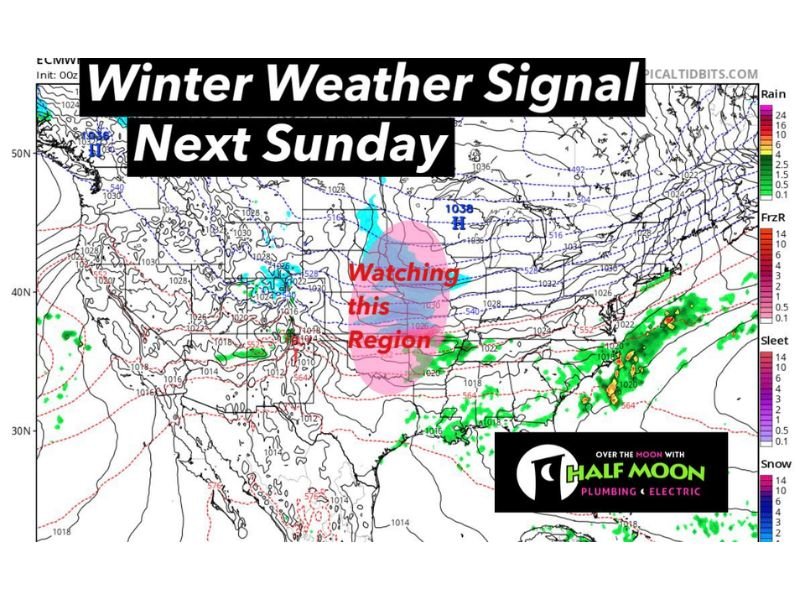
Current model projections highlight a region across the central Plains and Midwest as an area to monitor. The map indicates a possible dip in upper-level energy combined with a surface high pressure system building to the north, which could allow colder air to spill southward.
The zone being watched includes portions of:
- Nebraska
- Kansas
- Missouri
- Iowa
- Illinois
- Surrounding Midwestern states
This does not appear to be a prolonged cold outbreak. Instead, it looks more like a quick-moving system that would deliver a short-lived drop in temperatures before moderating again.
Not a Lock — Just an Early Heads-Up
Forecasters emphasize that this is not a guaranteed scenario. With several days still to go, there is ample time for model adjustments that could weaken, delay, or shift the cold push entirely.
At this range, it is best viewed as a developing trend rather than a finalized forecast.
As we move deeper into late winter and early spring, atmospheric transitions often produce sharp but brief temperature swings. These quick pattern changes are common this time of year as the jet stream begins to fluctuate more dramatically.
A Reminder That Winter Can Linger
Even as spring approaches on the calendar, cold air intrusions remain possible — especially across the central and northern U.S. where snowpack, lingering Arctic air masses, and shifting pressure systems can still influence temperatures.
If this signal holds, some areas could experience a noticeable cooldown Sunday into early next week before temperatures rebound. At this time, no significant winter storm is indicated with this cold push in the highlighted region — just the potential for below-average temperatures for a short window.
What Happens Next
Forecast confidence should improve over the coming days as additional model runs refine the timing and strength of the potential cold shot.
Residents across the central U.S. should stay tuned for updates as meteorologists continue monitoring the evolving pattern. Spring transitions can change quickly — sometimes within just a few forecast cycles. For continued updates on developing weather trends and pattern changes nationwide, stay connected with CabarrusWeekly.com.