Wisconsin and Michigan Face 2–3 Feet of Snow as Winter Storm Iona Targets Green Bay, Marquette, Alpena and Surrounding Upper Midwest Cities
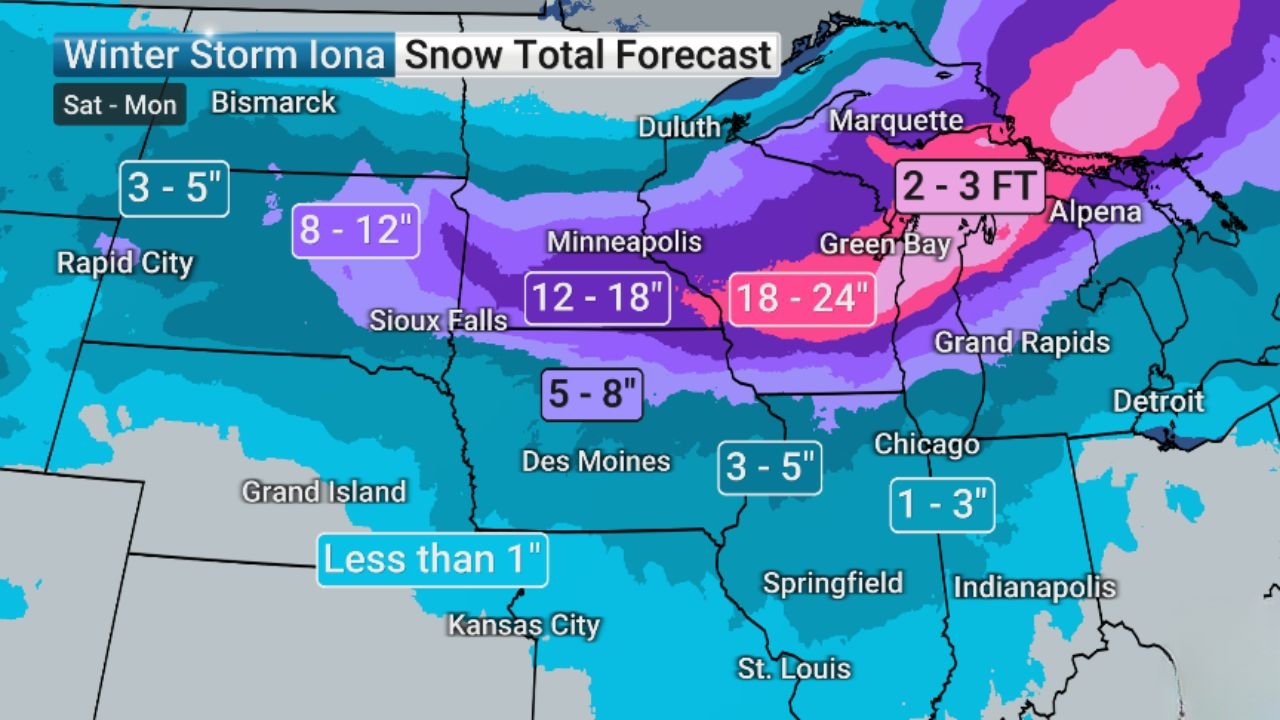
UNITED STATES — A powerful winter system dubbed Winter Storm Iona is set to unload extraordinary snowfall totals across the Upper Midwest from Saturday through Monday, with some areas in Wisconsin and Michigan projected to receive an astonishing 2 to 3 feet of snow.
Forecast maps indicate a sprawling swath of heavy accumulation stretching from eastern South Dakota and southern Minnesota into central and northern Wisconsin and deep into Michigan’s Upper Peninsula.
18–24 Inches from Central Wisconsin into Michigan
One of the most intense snowfall corridors is forecast to extend from:
- Minneapolis, Minnesota
- Across central Wisconsin near Green Bay
- Into Michigan’s Upper Peninsula near Marquette
- Eastward toward Alpena
Within this zone, widespread totals of 18–24 inches are expected, with localized areas exceeding those amounts.
Parts of northern Michigan and areas near Marquette and Alpena are highlighted for the most extreme totals, where 2–3 feet of snow may accumulate by the time the storm exits.
Major Cities in the Heavy Snow Zone
The following metro areas are positioned for significant impacts:
- The Twin Cities (Minneapolis–St. Paul) – 12–18 inches
- Madison, Wisconsin – 12–18 inches
- Milwaukee, Wisconsin – near the heavier gradient zone
- Green Bay, Wisconsin – 18–24 inches
- Marquette, Michigan – potentially 2–3 feet
- Traverse City, Michigan – heavy accumulations likely
Grand Rapids, Michigan also appears within the broader heavy snow shield, though totals may taper slightly compared to areas farther north.
Sharp Snowfall Gradient Southward
Snow totals drop off noticeably farther south:
- Des Moines, Iowa – 5–8 inches
- Chicago, Illinois – 1–3 inches
- Springfield, Illinois – lighter totals
- Indianapolis, Indiana – minimal accumulations
- Kansas City, Missouri – less than 1 inch
This sharp gradient suggests a tightly packed storm track, where a shift of even 50–100 miles could dramatically change totals in some areas.
Western Edge: Lighter but Still Impactful
Areas near Rapid City, South Dakota are projected to receive around 3–5 inches, while Sioux Falls sits in the 8–12 inch zone.
The heaviest snow core clearly centers over Minnesota, Wisconsin, and Michigan.
Travel and Infrastructure Concerns
With snowfall rates potentially exceeding 1–2 inches per hour at times in the heaviest band, conditions could rapidly deteriorate across:
- Interstates in Minnesota and Wisconsin
- Highway corridors near Green Bay
- Upper Peninsula roadways
- Airport operations in Minneapolis and northern Michigan
If 2–3 feet materializes in parts of Michigan’s Upper Peninsula, this would rank among the more significant snow events of the season.
Timing: Saturday Through Monday
The storm is expected to unfold over multiple days, increasing the risk of prolonged travel disruptions and compounding impacts as snow accumulates steadily.
Blowing and drifting may also become an issue if winds increase alongside heavy snowfall.
Bottom Line
Winter Storm Iona is poised to deliver a major late-season winter punch to the Upper Midwest, with parts of Wisconsin and Michigan facing the possibility of measured snowfall in feet, not inches.
Residents in Minneapolis, Madison, Milwaukee, Green Bay, Marquette, Traverse City, and surrounding communities should prepare for significant travel disruptions and potential infrastructure strain.
CabarrusWeekly.com will continue tracking this developing winter storm and provide updates as the forecast evolves.