Wisconsin Braces for 12+ Inches of Snow and 40 MPH Wind Gusts as Green Bay Warns of Near-Blizzard Conditions from Saturday Night Through Monday
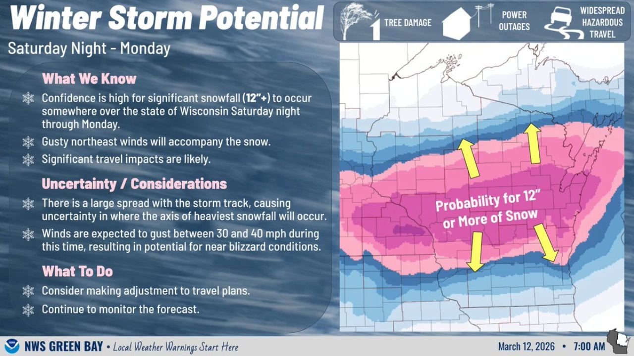
UNITED STATES — Confidence is increasing that a significant winter storm will impact Wisconsin from Saturday night through Monday, with widespread snowfall totals of 12 inches or more possible and wind gusts strong enough to create near-blizzard conditions.
The latest forecast guidance highlights a broad zone across central and northern Wisconsin where the probability of at least one foot of snow is elevated. Gusty northeast winds are expected to accompany the storm, increasing the risk for hazardous travel and reduced visibility.
12+ Inches Likely Somewhere in Wisconsin
Forecasters indicate high confidence that significant snowfall — defined as 12 inches or more — will occur somewhere in the state during the weekend system.
The corridor with the highest probability stretches across:
- Central Wisconsin
- Northeastern Wisconsin
- Areas near Green Bay
- Inland areas away from the immediate southern border
While exact placement of the heaviest snow band remains uncertain, a large portion of the state is under the threat zone for impactful accumulations.
Winds 30–40 MPH Could Create Near-Blizzard Conditions
In addition to heavy snowfall, gusty northeast winds are expected to range between 30 and 40 mph. If these wind speeds coincide with heavier snowfall rates, visibility could be dramatically reduced.
Near-blizzard conditions may develop in open areas, particularly in rural and exposed regions where blowing and drifting snow become more pronounced.
Strong winds could also increase the risk of:
- Tree damage
- Isolated to scattered power outages
- Widespread hazardous travel
Travel Impacts Likely Across the State
The storm is expected to unfold from Saturday night through Monday, covering multiple travel periods and increasing the likelihood of prolonged disruptions.
Snow-covered roads, drifting, and reduced visibility may impact major highways and secondary roads alike. Commuters and weekend travelers across Wisconsin should prepare for changing conditions and consider adjusting travel plans if necessary.
Forecast Uncertainty Remains
While confidence is high that significant snowfall will occur somewhere in Wisconsin, there is still notable uncertainty regarding the exact storm track.
A slight shift north or south could alter where the axis of heaviest snowfall ultimately sets up. This means some communities could see totals well above a foot, while others may receive lower — though still impactful — amounts.
Forecasters stress that the spread in model solutions makes it critical to monitor updated forecasts through the coming days.
What Residents Should Do
Officials advise:
- Monitoring the latest forecast updates
- Preparing for potential travel disruptions
- Securing emergency supplies in case of power outages
- Considering adjustments to weekend travel plans
Bottom Line
A significant winter storm is increasingly likely to bring 12 or more inches of snow to parts of Wisconsin this weekend, accompanied by 30–40 mph wind gusts capable of producing near-blizzard conditions.
With hazardous travel, possible power outages, and heavy snow all on the table, residents across the state should begin preparing now as confidence in a high-impact event continues to grow.
CabarrusWeekly.com will continue providing updates as the storm track and snowfall projections become clearer.