Wisconsin, Iowa, Illinois, Indiana, Ohio, Michigan, and Pennsylvania Face Isolated to Scattered Severe Storm Threat Monday and Tuesday With Damaging Winds, Hail, and Low-End Tornado Risk
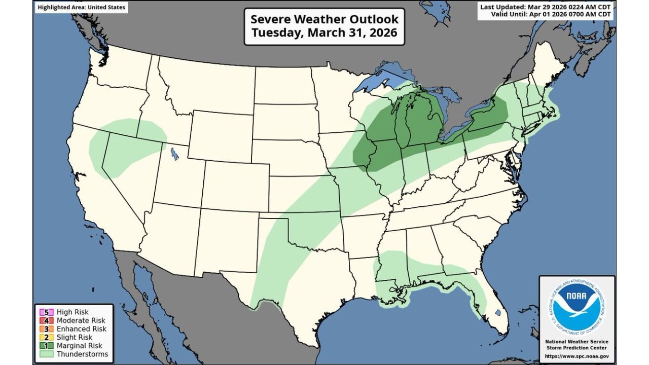
UNITED STATES — The Midwest is heading into a two-day severe weather window starting Monday, March 30 and continuing into Tuesday, March 31, 2026. The Storm Prediction Center has issued severe weather outlooks for both days, with the threat centered across the Great Lakes states and upper Ohio Valley. Damaging winds and large hail are the primary hazards, with a low-end tornado threat also possible — particularly on Tuesday as the risk area expands eastward.
Both outlooks were issued by the NOAA/NWS Storm Prediction Center.
How the Two-Day Threat Sets Up
Monday starts relatively quiet across most of the country, but the atmosphere is not completely settled across the Midwest. A few isolated to scattered severe storms are possible during the afternoon and evening hours, focused on a corridor running through Wisconsin, Iowa, Illinois, and Michigan.
Tuesday brings a more organized and widespread threat. The risk area expands significantly eastward into Indiana, Ohio, and Pennsylvania as the weather system driving storm development pushes through the region. Tuesday is the day forecasters are watching more closely — and the day where the tornado threat, while still low-end, becomes more of a consideration.
Monday, March 30 — Slight Risk Across Wisconsin, Iowa, Illinois, and Michigan
The SPC has placed Wisconsin, Iowa, Illinois, and Michigan under a Slight Risk (Level 2 of 5) for severe weather Monday. A broader Marginal Risk zone extends outward through surrounding states, including portions of the Gulf Coast and the Southwest.
Storms on Monday will be isolated to scattered in coverage — meaning not everyone in the risk zone will see severe weather, but those that do could encounter damaging wind gusts and large hail. The afternoon hours carry the highest potential as daytime heating destabilizes the atmosphere ahead of the approaching system.
Tuesday, March 31 — Slight Risk Expands Into Indiana, Ohio, and Pennsylvania
Tuesday represents the more significant of the two days. The Slight Risk zone expands eastward to include Illinois, Indiana, Ohio, Michigan, and Pennsylvania, with a large Marginal Risk area stretching from the Plains and Gulf Coast all the way through the Mid-Atlantic and New England states.
The tornado threat increases on Tuesday as the upper-level system organizes further and wind shear increases across the Ohio Valley and Great Lakes corridor. While the overall tornado risk remains low-end, the combination of increasing shear and available moisture means isolated tornado development cannot be ruled out — particularly across Indiana, Ohio, and southwestern Pennsylvania during the afternoon and evening hours.
Severe Weather Risk by Day and State
| State | Monday March 30 | Tuesday March 31 |
|---|---|---|
| Wisconsin | Slight Risk | Marginal Risk |
| Iowa | Slight Risk | Marginal Risk |
| Illinois | Slight Risk | Slight Risk |
| Michigan | Slight Risk | Slight Risk |
| Indiana | Marginal Risk | Slight Risk |
| Ohio | Marginal Risk | Slight Risk |
| Pennsylvania | Marginal Risk | Slight Risk |
| Nevada / Utah / Arizona | Marginal Risk | Marginal Risk |
| Gulf Coast states | Marginal Risk | Marginal Risk |
| New England | No Risk | Marginal Risk |
Primary Hazards Both Days
Damaging winds are the number one threat across both days. Severe thunderstorm wind gusts of 58 mph or greater are possible with the strongest storm cells, capable of downing trees, snapping power lines, and causing structural damage to poorly constructed buildings and outbuildings.
Large hail is the second primary threat. Hail of one inch in diameter or larger — roughly golf ball size — is possible with the strongest supercell storms, particularly on Tuesday as the atmosphere becomes better organized. Hail of this size can damage vehicles, break windows, and cause significant harm to crops and property.
Low-end tornado threat on Tuesday — while not the headline threat, an isolated tornado cannot be ruled out across the Slight Risk zone Tuesday afternoon and evening. Indiana, Ohio, and southwestern Pennsylvania carry the highest tornado potential of the two-day period.
Forecast Confidence Level
High confidence on the overall two-day severe weather threat across the Midwest and Great Lakes — the SPC outlooks are consistent with the underlying model data supporting storm development both days.
High confidence on damaging winds and hail as primary hazards — wind shear and instability values support these threats across both days.
Medium confidence on tornado potential Tuesday — the low-end tornado threat is real but dependent on storm mode and surface boundary positioning that will become clearer Monday morning.
What Midwest and Great Lakes Residents Must Do
Have a severe weather plan ready before Monday afternoon. Know your shelter location at home and at work — an interior room on the lowest floor away from windows is your safest option during a tornado warning.
Download a weather alert app and enable notifications. Severe thunderstorm warnings and tornado warnings can be issued with very little lead time during fast-moving spring storm systems. Having alerts pushed directly to your phone is critical.
Secure outdoor items before storms arrive. Lawn furniture, trampolines, potted plants, and any lightweight outdoor objects can become dangerous projectiles in 60+ mph wind gusts.
Do not shelter in a vehicle or mobile home during a tornado warning. Both offer virtually no protection. Get to a sturdy building immediately if a warning is issued for your area.
Tuesday carries more risk than Monday — if you have outdoor plans or travel scheduled for Tuesday afternoon in Indiana, Ohio, Michigan, Illinois, or Pennsylvania, monitor forecasts closely Monday evening for updated guidance.
The Bottom Line
The Midwest and Great Lakes face a two-day severe weather window Monday and Tuesday with the threat centered across Wisconsin, Iowa, Illinois, Indiana, Ohio, Michigan, and Pennsylvania. Damaging winds and large hail are the primary hazards both days. A low-end tornado threat emerges Tuesday as the risk area expands eastward into the Ohio Valley. Monday is a limited, isolated threat — Tuesday is the day to watch more closely. Stay weather aware through both days.
Stay ahead of dangerous weather before it reaches your door. Visit cabarrusweekly.com for daily severe weather coverage, storm alerts, and forecast updates from across the United States — because knowing early is the difference that matters.