Wisconsin, Michigan, Illinois and Mississippi Valley Braced for “Whopper” Storm: Blizzard, EF2+ Tornado Risk and Fire Weather Threat Sunday, March 15
UNITED STATES — A sprawling and potentially high-impact storm system is set to slam the central and eastern United States on Sunday, March 15, bringing everything from blizzard conditions in Wisconsin and Michigan to significant tornado risk in the Mississippi Valley — and even wildfire danger across parts of the Plains.
Forecasters are calling it a “whopper” of a system, and the impacts will stretch from the Upper Midwest to the Deep South.
Severe Storms: Mississippi Valley to Midwest
On the warm side of the system, a dangerous severe weather episode is expected across:
- Mississippi
- Tennessee
- Arkansas
- Western Kentucky
- Southern Illinois
- Indiana
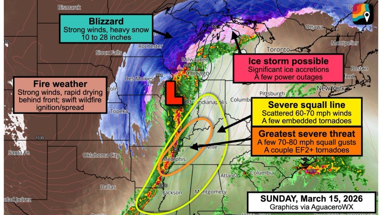
A powerful squall line — known as a QLCS — is forecast to develop and race northeast. This line could produce:
- Widespread 60–70 mph wind gusts
- Pockets of 70–80 mph destructive winds
- Embedded tornadoes
- A couple of EF2+ tornadoes in the most intense cells
The greatest severe threat appears centered from near Memphis, Tennessee, northward toward portions of western Tennessee, western Kentucky and southern Illinois.
Storms will be capable of quick spin-ups within the line, meaning tornado warnings could be issued with little lead time.
Blizzard Conditions: Wisconsin and Upper Peninsula of Michigan
On the cold side of the low-pressure system, conditions will be dramatically different.
Blizzard conditions are expected across:
- Much of Wisconsin
- The Upper Peninsula of Michigan
Forecast guidance shows the potential for 10 to 28 inches of snow, with localized totals approaching or exceeding two feet in some areas.
Strong winds wrapping around the system will create whiteout conditions and dangerous travel. Interstates near Milwaukee and across northern Wisconsin could become extremely hazardous.
Ice Storm Risk: Lower Michigan
Meanwhile, parts of Lower Michigan — “the mitten” — may deal with a significant ice storm.
Simulated ice accretion amounts are trending upward, raising concerns for:
- Power outages
- Tree damage
- Slick road conditions
Even moderate ice accumulation combined with gusty winds can bring down power lines and create extended outages.
Fire Weather Threat: The Plains
Behind the system, strong northwesterly winds and rapid drying will overspread portions of the central and southern Plains, including:
- Kansas
- Oklahoma
- Western Texas
These conditions could promote rapid wildfire ignition and spread. While it is too early to declare a major wildfire outbreak, forecasters are highlighting elevated fire weather risk, especially in the High Plains.
Air Travel Disruptions Likely
With severe storms, blizzard conditions, and ice all occurring within the same storm system, major travel hubs across:
- Chicago
- Milwaukee
- Detroit
- St. Louis
- Memphis
could experience delays or cancellations.
Air travelers are encouraged to monitor airline advisories and consider adjusting plans as fee waivers are issued.
Bottom Line
This Sunday’s storm system will impact nearly every region of the central and eastern United States in some way — from 70–80 mph winds and tornadoes in the Mississippi Valley, to blizzard conditions in Wisconsin and the Upper Peninsula of Michigan, to ice accumulation in Lower Michigan and fire weather concerns across the Plains.
CabarrusWeekly.com will continue to track this multi-hazard storm as timing and impact details become clearer heading into Sunday.