Wyoming East of the Continental Divide Sees Light Snow Tonight Through Friday as Arctic Front Pushes South
UNITED STATES — Areas east of the Continental Divide in Wyoming will see light snow develop tonight and continue through Friday evening as a cold Arctic front advances southward across the state. Forecast guidance indicates snowfall amounts will remain very light, generally under 1 inch, due to the extremely cold and dry nature of the Arctic air mass moving in.
Where the Light Snow Will Develop
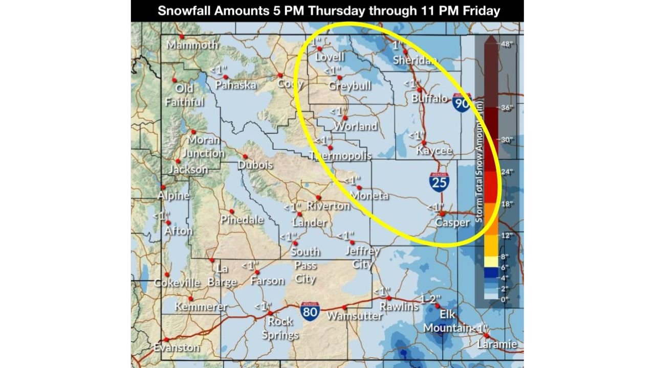
According to the latest forecast imagery, the primary area of impact includes:
- The I-25 Corridor, including locations near Buffalo, Kaycee, Casper, and Sheridan
- Eastern portions of the Bighorn Basin
- Nearby surrounding communities east of the Divide
Snow will begin this evening as the front pushes south, with intermittent light snow or flurries lingering into Friday.
Snowfall Amounts Expected to Stay Minimal
Despite the arrival of colder air, moisture with this system is limited.
- Most areas: Less than 1 inch of total snowfall through Friday evening
- Localized spots: A 20–25% chance of exceeding 1 inch along parts of I-25 and the western slopes of the Bighorn Mountains
The lack of deeper moisture will prevent heavier accumulation, keeping impacts mostly minor.
Why This Is a Low-Impact Snow Event
This setup is driven by a very cold, dry Arctic air mass, which limits snow production even as temperatures drop. While snow will be visible and persistent at times, it will generally be light and powdery, with minimal accumulation on most roadways.
However, colder temperatures can still allow slick spots, especially overnight and during early morning hours.
Travel and Weather Impacts
While significant disruptions are not expected, residents and travelers should be aware of:
- Reduced visibility at times due to light snow
- Isolated slick roads, especially bridges and untreated surfaces
- Colder temperatures settling in behind the front
Conditions should gradually improve Friday night as snow chances diminish.
What Happens Next
The Arctic air mass will remain in place after snowfall ends, keeping temperatures well below normal into the weekend. Any additional snow chances will depend on whether deeper moisture can return, which is not indicated in the current forecast.
Cabarrus Weekly will continue to monitor conditions across Wyoming and provide updates if snowfall coverage or impacts change.