Texas, Louisiana, Mississippi, Alabama, Georgia and Florida Face Warmer-Than-Normal Early March While Arkansas, Tennessee and Kentucky See Increased Rainfall Chances
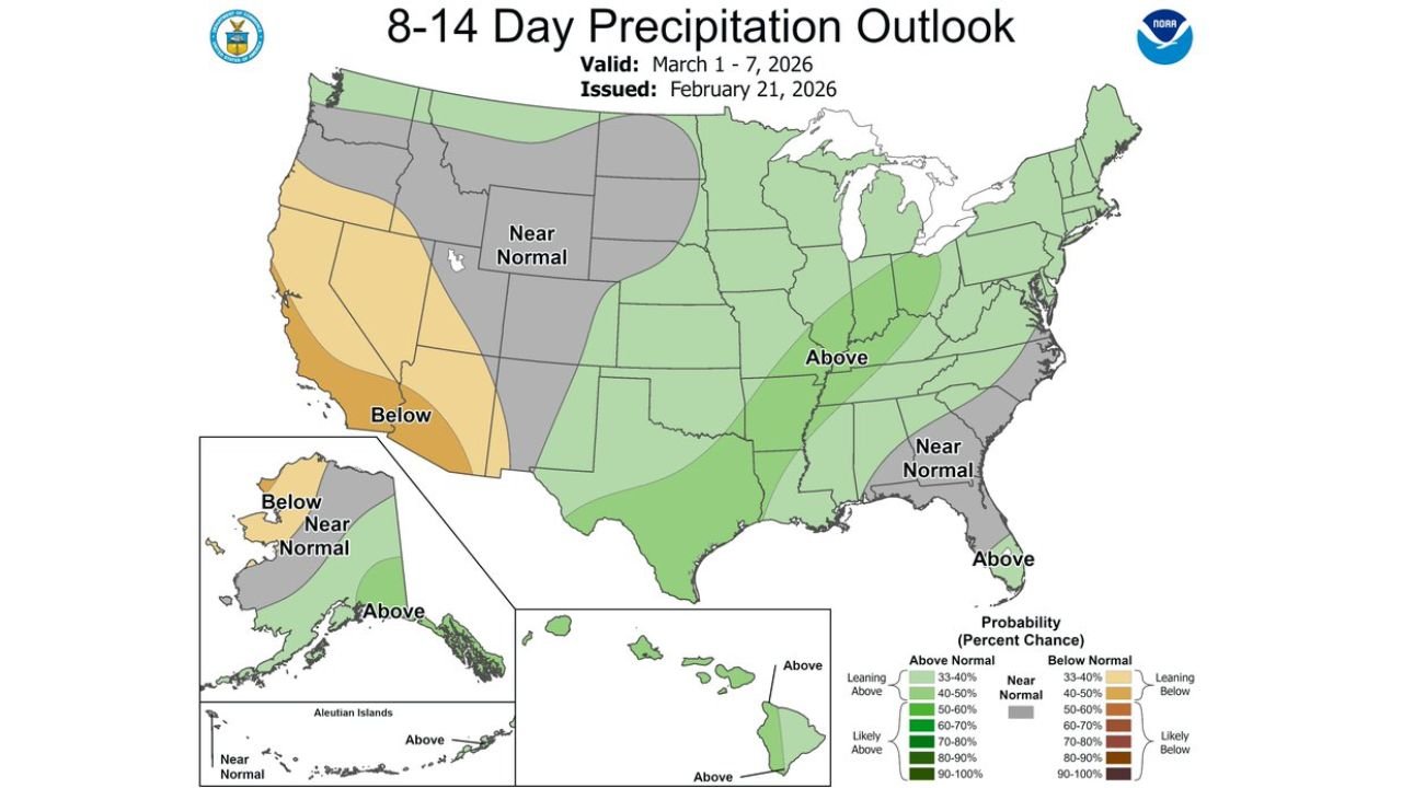
UNITED STATES — The latest 8–14 day outlook valid March 1 through March 7, 2026, shows a continuation of unsettled weather in parts of the country, followed by a transition toward warmer conditions across much of the South during the first week of March.
NOAA’s precipitation and temperature outlook maps indicate distinct regional contrasts heading into early spring.
Above-Normal Rainfall Favored in Parts of the Southeast and Ohio Valley
The precipitation outlook highlights an area of above-normal rainfall probability stretching from eastern Texas through the Lower Mississippi Valley, Tennessee Valley, and into portions of the Ohio Valley and Southeast.
Green shading across states such as Arkansas, Mississippi, Tennessee, Kentucky, and parts of the Carolinas and Georgia suggests a higher likelihood of wetter-than-average conditions during the March 1–7 window.
Meanwhile, portions of the West Coast, particularly parts of California and the Southwest, lean toward below-normal precipitation, indicating drier conditions compared to average.
Areas along parts of the Mid-Atlantic and central Rockies are shown as near normal, suggesting no strong precipitation signal in either direction.
Warmer-Than-Normal Temperatures Expand Across the Southern Tier
The temperature outlook paints a broad swath of above-normal warmth from California and the Southwest across Texas, the Gulf Coast, and much of the Southeast.
States including Arizona, New Mexico, Texas, Louisiana, Mississippi, Alabama, Georgia, and Florida are all shaded in orange to red tones, indicating elevated probabilities of warmer-than-average temperatures.
This warmth also extends northward into portions of the central Plains and Midwest, though the strongest warm signal is centered across the southern half of the country.
Cooler Pockets in the Northern Tier
In contrast, parts of the Upper Midwest and Great Lakes show a near normal to slightly below-normal temperature signal, while sections of northern New England lean cooler than average.
This suggests that while the South trends warmer, the northern tier may experience more seasonable or slightly cooler conditions during the same period.
Transition Toward a Milder Early March
The overall pattern suggests continued unsettled weather in the short term, especially in regions favored for above-normal precipitation. However, the temperature outlook supports a broader warming trend across the southern United States as March begins.
For the Southeast, this combination could mean periodic rainfall events paired with milder daytime temperatures, particularly along the Gulf Coast and into the Carolinas.
As always, 8–14 day outlooks highlight probabilities rather than exact outcomes, and finer-scale storm systems will ultimately determine local impacts.
Stay updated on evolving early March weather trends and regional impacts at CabarrusWeekly.com, and share how the changing pattern is affecting your area.