Iowa and Nebraska Border Communities Including Sioux City Face Level 2 Slight Risk Tonight With Isolated Tornado, Large Hail and Damaging Winds Possible
WESTERN IOWA AND EASTERN NEBRASKA — The Storm Prediction Center has upgraded areas along the Iowa and Nebraska border to a Level 2 out of 5 Slight Risk for severe weather this evening, with thunderstorms possible near the Missouri River corridor as a weak disturbance moves through the region. If storms develop, they could quickly become severe with damaging wind gusts, large hail and an isolated tornado that cannot be ruled out. Additional storms are already developing farther north near southeastern South Dakota and pose a continuing threat as they track southeast.
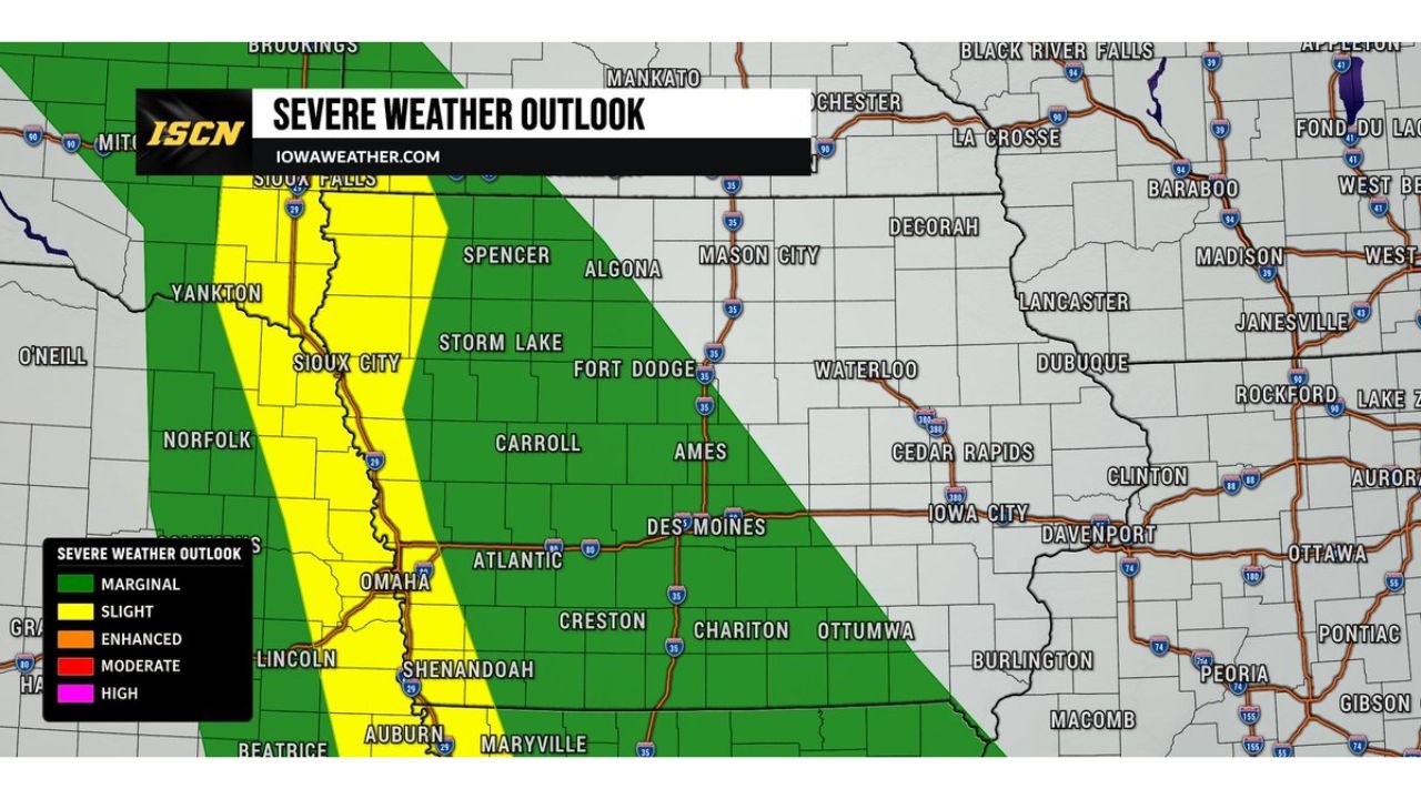
The Slight Risk Zone
The severe weather outlook map shows a narrow Slight Risk corridor in yellow running along the Iowa and Nebraska border from the Sioux Falls and Yankton area southward through Sioux City, Omaha and Lincoln down to Shenandoah and Auburn. This corridor sits along the Missouri River valley, the precise area where storm development is most likely this evening.
A broader Marginal Risk zone in green covers a large portion of western and central Iowa including Storm Lake, Carroll, Fort Dodge, Ames and Des Moines, keeping lower-end severe weather chances alive across a much wider footprint through the evening hours.
Two Separate Storm Threats Tonight
Forecasters are tracking two distinct areas of storm activity:
Threat 1: Missouri River Corridor Thunderstorms may develop near the Missouri River during the evening hours as the weak disturbance moves through. If storms can initiate, the environment supports rapid intensification into severe weather. Primary hazards include damaging winds, large hail and an isolated tornado.
Threat 2: Southeastern South Dakota Storms Storms are already developing near southeastern South Dakota and are expected to continue tracking southeastward into the Iowa and Nebraska border region. These storms carry the same hazard profile: large hail, damaging winds and a brief tornado possible as they move into the Slight Risk zone.
Cities Most at Risk Tonight
Communities along the Slight Risk corridor should remain weather-aware through the evening and overnight hours:
- Sioux City, Iowa
- Yankton, South Dakota
- Omaha and Lincoln, Nebraska
- Norfolk, Nebraska
- Shenandoah and Auburn on the southern end
- Carroll and Storm Lake in the broader Marginal zone
Important Context for Western Iowa Residents
Forecasters are clear that widespread severe weather is not expected across Iowa tonight. The threat is focused specifically on western Iowa near the Nebraska border. Residents east of this corridor have a much lower risk, but should remain weather-aware given the marginal risk coverage across the western half of the state.
Stay with CabarrusWeekly.com for continuing updates as evening storm development is monitored along the Iowa and Nebraska border.