Minnesota, Michigan, Colorado and Washington D.C. Warm Up 4 to 11 Degrees Above Normal June 5 to 10 While Texas, Louisiana and Florida Hold Near Average
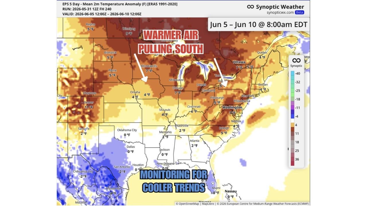
UNITED STATES — A medium-term warm-up is taking shape across the northern and central United States for the period of June 5 through June 10, 2026, with above-normal temperatures pushing southward as the second week of June arrives. The 5-day mean temperature anomaly map shows warmer than normal air dominating a broad swath from the northern Plains through the Great Lakes and Mid-Atlantic, while the Deep South and Gulf Coast remain near or below average. A recurving Pacific typhoon adds a wildcard that could push the South Central and Deep South even cooler than currently forecast.
Where the Warmth Is Headed: June 5 to 10
The temperature anomaly map, valid from June 5 at 12Z through June 10 at 12Z, shows the warmest departures concentrated across the northern tier. Key city anomalies from the map:
| City | Temperature Anomaly |
|---|---|
| Denver, Colorado | +11 F above normal |
| Minneapolis, Minnesota | +7 F above normal |
| Chicago, Illinois | +7 F above normal |
| Washington D.C. | +7 F above normal |
| Winnipeg, Canada | +9 F above normal |
| Ottawa, Canada | +7 F above normal |
| Pittsburgh, Pennsylvania | +5 F above normal |
| Boston, Massachusetts | +4 F above normal |
| Bismarck, North Dakota | +5 F above normal |
| Pierre, South Dakota | +5 F above normal |
| Omaha, Nebraska | +4 F above normal |
| St. Louis, Missouri | +4 F above normal |
| Cincinnati, Ohio | +4 F above normal |
| Raleigh, North Carolina | +5 F above normal |
| Norfolk, Virginia | +4 F above normal |
The deep red and brown shading across Canada, the northern Plains, Great Lakes and Mid-Atlantic confirms this is a broad and significant warm anomaly covering much of the eastern two-thirds of the country north of the Ohio Valley.
Where Temperatures Stay Near or Below Normal
The South Central United States and Deep South tell a different story. Near-zero anomalies are forecast across a large zone:
- Oklahoma City, Dallas and Houston all sitting at 0 F anomaly
- Memphis, Jackson and New Orleans at 0 F or near normal
- Atlanta showing only +2 F above normal
- Nashville at +2 F
- Miami and Nassau near 0 F anomaly
- San Antonio at -2 F below normal
- Chihuahua City at -2 F below normal
The blue shading across portions of the Southwest, southern Texas and northern Mexico indicates below-normal temperatures persisting in those areas through the June 5 to 10 window.
The Pacific Typhoon Wildcard
Forecasters are flagging a recurving typhoon in the Pacific as a factor that could further enhance the cool pattern across the South Central and Deep South beyond what the current maps are showing. If the typhoon’s recurvature influences the atmospheric pattern as anticipated, areas from Texas through the Gulf States could trend even cooler than the current near-normal forecast suggests. This is an active monitoring situation heading into the second week of June.
The Bigger Picture: Up and Down Pattern
The week ahead is characterized as an up-and-down temperature pattern before more consistently warm air becomes established across the northern United States heading into mid-June. The June 5 to 10 warm-up across the north is part of this evolving pattern, with the warmth expected to become more entrenched as the month progresses.
Stay with CabarrusWeekly.com for continuing updates as the June temperature pattern evolves across the United States.