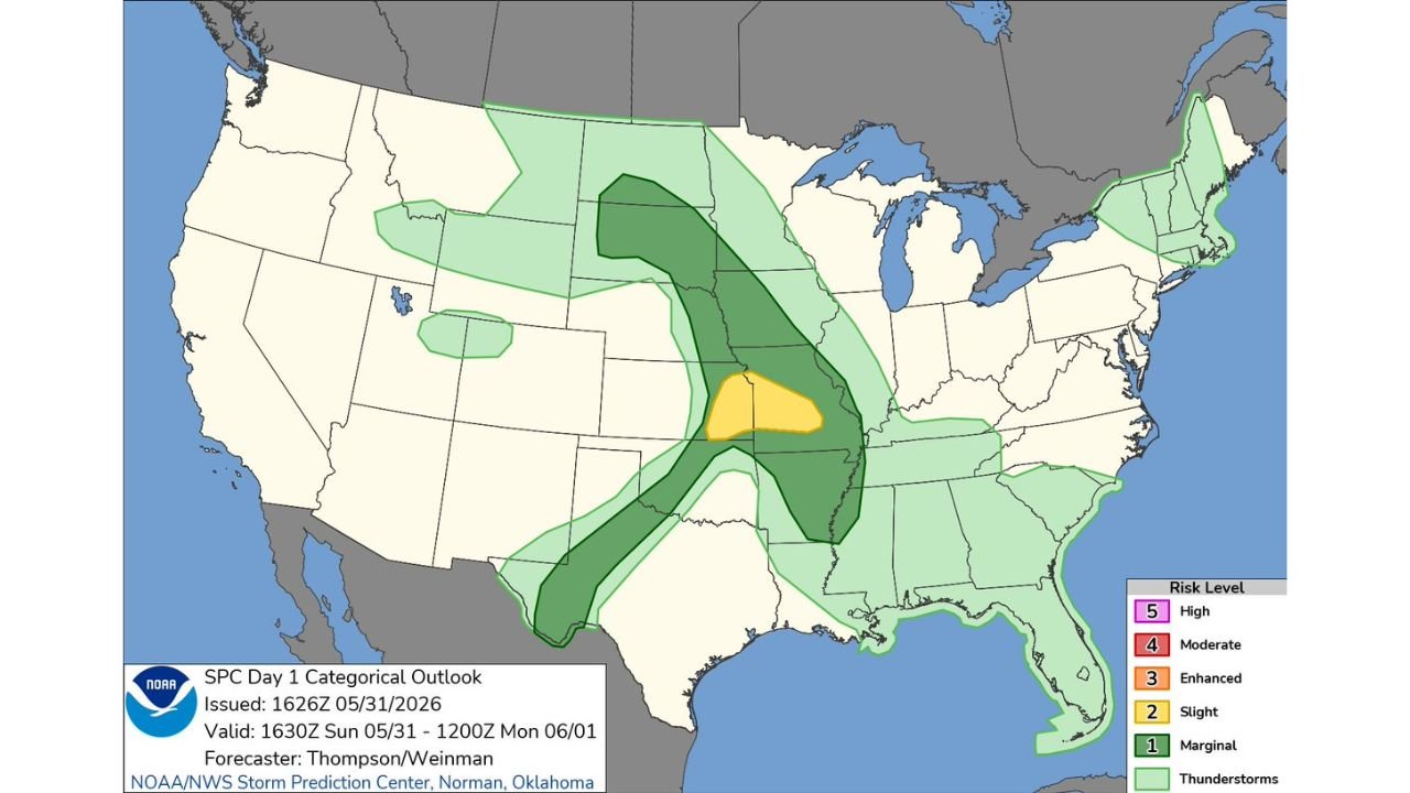
Missouri and Illinois Face Level 2 Slight Risk for Damaging Winds and Large Hail After 6 PM Sunday as SPC Outlook Covers Central Plains to Deep South
MISSOURI AND ILLINOIS — The Storm Prediction Center has issued a Level 2 out of 5 Slight Risk for severe weather valid from 1630Z Sunday, May 31 through 1200Z Monday, June 1, 2026, with the highest threat centered over Missouri and southern Illinois. Storms are not expected to develop in the Slight Risk zone until after 6 or 7 PM, with damaging winds and large hail identified as the most likely severe weather types.
The Risk Zone Breakdown
The SPC Day 1 Categorical Outlook issued at 1626Z on May 31, 2026 shows a multi-tiered risk area across the central United States:
Slight Risk (Yellow) — Level 2: The highest threat zone is tightly focused over Missouri and the southern Illinois border region. This is the area most likely to see organized severe thunderstorm activity after 6 PM, with damaging winds and large hail as the primary hazards.
Marginal Risk (Dark Green) — Level 1: Surrounds the Slight Risk core and covers a broad area including:
- Nebraska, Kansas and Iowa to the north and west
- Arkansas, Louisiana and Mississippi to the south
- Tennessee and Kentucky to the east
- Oklahoma and northern Texas on the southwestern edge
Thunderstorm Risk (Light Green): Covers the broadest footprint extending from the Pacific Northwest and northern Plains eastward through New England and the entire Southeast, keeping general thunderstorm chances alive well beyond the severe risk zones.
Timing: Nothing Until After 6 or 7 PM
A critical piece of information for residents in the Slight Risk zone is the delayed storm initiation timing. Forecasters are confident that no thunderstorms will form in the Level 2 zone until after approximately 6 or 7 PM. This means the afternoon hours remain quiet across Missouri and southern Illinois, with the severe weather window opening during the evening hours and continuing through the overnight period.
Primary Hazards Tonight
The two hazards forecasters are watching most closely for this event:
- Damaging winds identified as the most likely severe weather type across the Slight Risk zone
- Large hail also possible with the stronger storm cells that develop after 6 PM
Tornado potential is not specifically highlighted as a primary concern with this setup.
Cities in the Slight Risk Zone
Residents in the following communities should be prepared for potential severe weather after 6 PM Sunday evening:
- St. Louis and surrounding metro communities
- Springfield and Joplin, Missouri
- Southern Illinois communities near the Missouri border
- Cape Girardeau and the Bootheel region
Stay with CabarrusWeekly.com for continuing updates as Sunday evening storms develop across Missouri and southern Illinois.