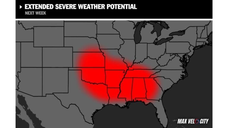
Significant Tornado Emergency Unfolding: Supercells Fire Near Albert Lea by 4 PM and Race Toward La Crosse Along a Volatile Warm Front as Southern Minnesota and Wisconsin Face an Enhanced Risk for Strong Tornadoes This Afternoon and Evening
SOUTHERN MINNESOTA AND WISCONSIN — This is not a routine severe weather alert. An Enhanced Risk for strong and significant tornadoes is in place this afternoon and evening across southern Minnesota into Wisconsin, and the setup is being taken seriously enough that professional storm chasing teams are deploying in full force. Supercells are expected to fire by 4 PM near and northwest of Albert Lea, Minnesota, then race east along a volatile warm frontal zone toward the La Crosse, Wisconsin area by evening. The corridor between those two cities is the most dangerous place to be in the country this afternoon.
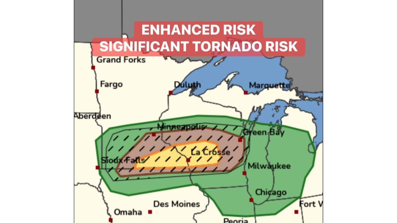
This Is an Enhanced Risk — Significant Tornado Threat
The outlook is unambiguous. Enhanced Risk — Level 3 of 5 is in place for a defined corridor across southern Minnesota and Wisconsin, and inside that Enhanced Risk zone sits a Significant Tornado Risk — denoted by the hatched area on the outlook map. The hatching is critical. It means that strong, long-track tornadoes are not just possible — they are specifically anticipated from the supercell storms expected to develop and move through the region this afternoon and evening.
The Significant Tornado Risk zone is tightly centered on the corridor running from the Sioux Falls and Minneapolis area east through La Crosse and toward Green Bay and Milwaukee. This is the exact path the supercells are forecast to travel this afternoon and evening.
Risk Zones — Southern Minnesota Into Wisconsin
| Risk Level | Areas Covered |
|---|---|
| Significant Tornado Risk — hatched zone | Albert Lea to La Crosse corridor — the direct supercell path |
| Enhanced Risk — Level 3/5 | Southern Minnesota including Minneapolis, Sioux Falls area east through La Crosse and toward Green Bay |
| Marginal to Slight Risk | Broader surrounding area including Fargo, Grand Forks, Duluth, Milwaukee, Chicago, Des Moines, Omaha, Peoria, Fort Wayne |
The hatched Significant Tornado Risk zone sits directly over the forecast supercell track — from near Albert Lea and the Sioux Falls corridor northeast through the Minneapolis area and east toward La Crosse and beyond toward Green Bay. Anyone living along this corridor needs to treat this afternoon as a life-threatening weather situation.
The Timeline — How This Event Unfolds
Forecasters have laid out a clear and specific progression for how today’s tornado threat develops and moves.
| Time | Expected Conditions |
|---|---|
| Before 4 PM | Atmosphere loading — conditions building ahead of storm initiation |
| Around 4 PM | Supercells fire near and northwest of Albert Lea, Minnesota |
| 4 PM to Evening | Supercells move east along the volatile warm frontal zone |
| By Evening | Supercells reach La Crosse, Wisconsin area |
| Evening hours | Continued tornado threat as storms track east toward Green Bay corridor |
The warm frontal zone is the critical ingredient driving this tornado threat. Warm fronts create extremely volatile and favorable environments for supercell tornadoes by providing the wind shear, moisture, and lift that rotating storms need to develop and maintain long tracks. Supercells riding a volatile warm front are among the most dangerous storm scenarios in meteorology — and that is exactly the setup in place today across southern Minnesota and Wisconsin.
What Strong and Significant Tornadoes Mean
The language being used in today’s outlook — strong-plus tornadoes and significant tornado risk — carries specific meaning that goes beyond the standard tornado threat language used in typical severe weather events.
| Tornado Category | Wind Speed | Damage Description |
|---|---|---|
| EF-1 | 86-110 mph | Roof damage, mobile homes overturned, trees snapped |
| EF-2 | 111-135 mph | Roofs torn off, mobile homes destroyed, large trees uprooted |
| EF-3 | 136-165 mph | Entire floors of well-built homes destroyed, cars lifted and thrown |
| EF-4+ | 166+ mph | Well-constructed homes leveled, cars thrown significant distances |
Strong-plus tornadoes in the context of today’s outlook means EF-2 and above — the category where well-constructed homes sustain severe structural damage and the risk of fatalities becomes very real for anyone not in a substantial shelter below ground.
Albert Lea to La Crosse — The Corridor in the Crosshairs
The specific storm track forecast for today puts a defined and identifiable path in the crosshairs. From northwest of Albert Lea moving east along the warm frontal zone toward La Crosse — that corridor encompasses communities across southern Minnesota and western Wisconsin that could find themselves directly in the path of rotating supercells this afternoon and evening.
Communities between Albert Lea and La Crosse along the warm frontal corridor need to be treating this afternoon as a tornado emergency preparation situation right now, before 4 PM arrives and storms begin firing.
Minneapolis and the surrounding metro also sit within the Enhanced Risk and Significant Tornado Risk zone, making this not just a rural farming community threat — this is a major metropolitan area severe weather event with tornado potential.
Storm Chasers Are Deploying — That Tells You Something
The detail that professional storm chasing teams are activating full storm chasing operations today for this event is not incidental — it is meaningful. Professional chasers evaluate setups carefully and deploy resources selectively. A full deployment for the Albert Lea to La Crosse corridor signals that meteorologists and severe weather professionals with direct experience evaluating tornado setups view today’s threat as one of the more significant they have seen for this region.
When the professionals are in the field chasing this event, the public needs to be in the basement — not outside watching the sky.
What to Do Right Now — Before 4 PM
The supercells fire at 4 PM near Albert Lea. The window between now and that initiation time is your preparation window. Use every minute of it.
- Identify your tornado shelter immediately — basement or lowest floor interior room away from all windows — and make sure every person in your household knows exactly where to go
- Do not plan to outrun a tornado by vehicle — supercells moving along a warm frontal zone can be fast-moving, unpredictable, and capable of producing tornadoes with minimal warning time
- Charge all devices now and have a battery-powered weather radio ready in case power is knocked out by the storms before or during a tornado warning
- Set county-level alerts on your phone and keep the device with you and off silent mode throughout the entire afternoon and evening
- If you are in the Albert Lea to La Crosse corridor specifically — know that you are in the direct path of today’s forecast supercell track and treat the period from 4 PM through the evening as a high-alert tornado emergency window
- Do not go outside to look at the storms — a rotating supercell capable of strong tornadoes can drop a tornado with very little visible warning, particularly as storms move into the evening hours
Today’s Significant Tornado Threat — Full Summary
| Factor | Details |
|---|---|
| Risk level | Enhanced Risk — Level 3 of 5 |
| Tornado designation | Significant Tornado Risk — hatched zone |
| Tornado strength potential | Strong-plus — EF-2 and above possible |
| Supercell initiation | Around 4 PM near and northwest of Albert Lea, Minnesota |
| Storm track | Northeast along warm frontal zone toward La Crosse, Wisconsin |
| Primary threat cities | Albert Lea, Minneapolis, Sioux Falls, La Crosse, Green Bay corridor |
| Broader risk cities | Fargo, Duluth, Milwaukee, Chicago, Des Moines, Omaha |
| Storm chaser status | Full deployment activated |
| Threat period | This afternoon through evening |
Southern Minnesota and Wisconsin — Get Underground Before 4 PM
The supercells fire near Albert Lea at 4 PM. They ride a volatile warm front east toward La Crosse. They carry a Significant Tornado Risk with strong-plus tornado potential across one of the most clearly defined and dangerous setups of the season. Professional storm chasers are already deploying.
The message for southern Minnesota and Wisconsin today is as direct as it gets — know your shelter, get there when storms approach, and do not take chances with a Significant Tornado Risk Enhanced setup riding a volatile warm front toward your community.
Stay with CabarrusWeekly.com for live tornado coverage, storm reports, and warning updates across the Albert Lea to La Crosse corridor and the full southern Minnesota and Wisconsin tornado threat zone this afternoon and evening.