A Dangerous Severe Weather Setup Is Locked In Across the Midwest Today: Big-Time Hailstorms, Damaging Winds, and Strong Tornadoes Threaten Minneapolis, Rochester, Milwaukee, and Surrounding Areas Between 3 and 10 PM
UNITED STATES — The word being used by forecasters today is not “significant” or “elevated” — it is dangerous. A dangerous severe weather setup is locked in across the Midwest for this afternoon and evening, with the environment described as primed for big-time hailstorms and a tornado risk running from 3 PM straight through 10 PM. Very large hail, damaging winds, and a couple of strong tornadoes are all possible across a corridor centered on Minneapolis, Rochester, and the surrounding Upper Midwest before the threat winds down late tonight.
A Dangerous Setup — Not Just Another Severe Weather Day
The language matters in today’s forecast and forecasters are not mincing words. This environment is primed — meaning the atmosphere has loaded up the ingredients needed for significant severe weather across a well-defined zone of the Midwest. The threat window of 3 PM to 10 PM covers the entire afternoon and evening, and the hazards on the table represent all three major categories of severe weather occurring simultaneously across the same corridor.
Get vehicles, pets, trampolines, and any outdoor property under cover or secured before 3 PM — because once this event gets going, there will not be time to do it safely.
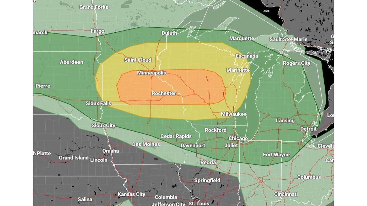
Risk Zones — The Midwest Bullseye
| Risk Level | Cities and Areas Covered |
|---|---|
| Enhanced Risk — Core orange zone | Minneapolis, Rochester, Sioux Falls, Saint Cloud, Marinette — the highest danger corridor |
| Slight Risk — Yellow zone | Sioux City, Des Moines, Cedar Rapids, Davenport, Rockford, Chicago, Joliet, Milwaukee, Duluth, Escanaba, Grand Forks, Fargo, Aberdeen |
| Marginal Risk — Green zone | Grand Island, Lincoln, Omaha, Kansas City, Springfield, Peoria, Fort Wayne, Detroit, Lansing, Sault Ste. Marie, Rogers City, Marquette |
The Enhanced Risk orange zone forms the most dangerous core of today’s setup, sitting directly over Minneapolis, Rochester, Sioux Falls, Saint Cloud, and the Marinette corridor. This is where the environment is most primed for all three hazard types — very large hail, damaging winds, and strong tornadoes — to occur together during the 3 to 10 PM window.
The Slight Risk yellow zone fans out broadly around that core, covering a massive swath of the Upper Midwest from the Dakotas south through Iowa and east through Wisconsin and Illinois into the Chicago and Milwaukee corridor. The Marginal Risk green zone extends even further, reaching from Kansas City and Springfield in the south to Omaha, Lincoln, Fort Wayne, Detroit, and Lansing in the east.
The Three Hazards in Play Today — 3 PM to 10 PM
Very Large Hail — The Big-Time Hailstorm Threat
The atmosphere today is specifically described as primed for big-time hailstorms. This is not standard hail language — it reflects an environment with the updraft strength and instability needed to produce very large hail across the Enhanced and Slight Risk zones. The most dangerous hail will accompany the strongest and most organized storm cores in the Minneapolis, Rochester, and Sioux Falls corridor during the afternoon hours.
Damaging Winds
Widespread damaging wind gusts are expected from the organized storm complex as it moves through the Midwest this afternoon and evening. Damaging winds capable of downing trees and power lines across a large area of the Upper Midwest represent one of the most impactful and widespread hazards of today’s event, particularly for the broader Slight Risk zone from Des Moines and Cedar Rapids east through Chicago and Milwaukee.
Strong Tornadoes — A Couple Possible
The tornado risk today is real and elevated. Forecasters specifically identify a couple of strong tornadoes as possible within the dangerous setup locked in across the Midwest. The Enhanced Risk zone covering Minneapolis, Rochester, and the surrounding corridor carries the highest tornado potential, and the timing of 3 to 10 PM means that both afternoon and evening tornado development are on the table.
Cities That Must Be on High Alert Today
| City | Risk Zone | Primary Threat |
|---|---|---|
| Minneapolis, Minnesota | Enhanced Risk | Very large hail, strong tornadoes, damaging winds |
| Rochester, Minnesota | Enhanced Risk | Very large hail, strong tornadoes, damaging winds |
| Saint Cloud, Minnesota | Enhanced Risk | Very large hail, strong tornadoes, damaging winds |
| Sioux Falls, South Dakota | Enhanced Risk | Very large hail, tornadoes, damaging winds |
| Marinette, Wisconsin | Enhanced Risk | All hazards |
| Milwaukee, Wisconsin | Slight Risk | Large hail, damaging winds, tornado threat |
| Chicago and Joliet, Illinois | Slight Risk | Large hail, damaging winds, tornado threat |
| Rockford, Illinois | Slight Risk | Large hail, damaging winds |
| Des Moines, Iowa | Slight Risk | Large hail, damaging winds |
| Cedar Rapids, Iowa | Slight Risk | Large hail, damaging winds |
| Davenport, Iowa | Slight Risk | Large hail, damaging winds |
| Duluth, Minnesota | Slight Risk | Large hail, winds |
| Fargo and Grand Forks | Slight Risk | Large hail, winds |
| Omaha and Lincoln | Marginal Risk | Scattered storm threat |
| Kansas City, Missouri | Marginal Risk | Scattered storm threat |
| Detroit and Lansing | Marginal Risk | Outer storm threat |
Protect Everything Before 3 PM
Forecasters are delivering a specific and practical warning to residents across the entire threat zone — protect your vehicles, pets, trampolines, and outdoor property before this afternoon’s storms arrive. Once the event gets underway between 3 and 10 PM, stepping outside to move a vehicle or secure property becomes genuinely dangerous.
- Get every vehicle into a garage or under solid cover before 3 PM — very large hail will total an unprotected car in seconds and there will be no warning time once a hailstorm arrives
- Bring all pets inside immediately — large hail, damaging winds, and tornado-producing storms are lethal to animals left outdoors
- Secure or bring in trampolines, patio furniture, and any outdoor equipment — damaging wind gusts will turn unsecured outdoor items into dangerous projectiles
- Identify your tornado shelter now and make sure every family member knows where to go — lowest floor, interior room, away from all windows
- Keep phone alerts active and weather radio on throughout the entire 3 to 10 PM window — tornado warnings can come with very little lead time in a fast-moving and primed severe weather environment
- Avoid all unnecessary travel between 3 and 10 PM across the Enhanced and Slight Risk zones — damaging winds, large hail, and tornado potential on the road is a life-threatening combination
Today’s Dangerous Midwest Severe Weather Event at a Glance
| Factor | Details |
|---|---|
| Threat description | Dangerous severe weather setup locked in |
| Threat window | 3 PM to 10 PM |
| Primary hazards | Very large hail, damaging winds, strong tornadoes |
| Enhanced Risk core | Minneapolis, Rochester, Saint Cloud, Sioux Falls, Marinette |
| Slight Risk zone | Des Moines, Cedar Rapids, Rockford, Chicago, Milwaukee, Duluth, Fargo |
| Marginal Risk zone | Omaha, Kansas City, Springfield, Fort Wayne, Detroit, Lansing |
| Tornado potential | A couple of strong tornadoes possible |
| Hail environment | Primed for big-time hailstorms |
| Action required | Vehicles, pets, and outdoor property secured before 3 PM |
3 PM Is the Starting Gun — Be Ready Before It Fires
The dangerous severe weather setup across the Midwest is locked in. The environment is primed. The 3 to 10 PM window covers the entire afternoon and evening. Minneapolis, Rochester, Saint Cloud, Sioux Falls, and Marinette sit in the Enhanced Risk bullseye with very large hail, damaging winds, and strong tornadoes all possible before tonight ends.
The clock is running toward 3 PM. Every minute before that is a preparation minute — get vehicles covered, pets inside, outdoor property secured, and shelter locations identified. Once this event starts across the Upper Midwest, it moves fast and it hits hard.
Stay with CabarrusWeekly.com for live severe weather coverage across the Midwest, real-time storm reports, tornado and severe thunderstorm warnings as they are issued, and updates throughout the dangerous afternoon and evening severe weather event.