Potentially Dangerous Night Ahead: Very Large Hail and Strong Tornadoes Threaten the Upper Midwest Today as Supercells Target Iowa, Illinois, and the Warm Front Corridor — and the Worst May Come After Dark
UPPER MIDWEST, UNITED STATES — A potentially dangerous severe weather event is taking shape across the Upper Midwest today, Monday April 13, 2026, and the threat may not end when the sun goes down. Significant severe storms are possible this afternoon and evening across parts of the region, carrying very large hail and strong tornadoes as the headline hazards. Multiple storm development zones are being watched simultaneously — and forecasters are warning that the significant severe and tornado threat may continue after dark, making tonight one of the most dangerous weather situations of the season so far.
Multiple Storm Development Zones — A Complex and Dangerous Setup
What makes today’s setup particularly concerning is not just the intensity of the storms expected — it is the number of separate areas where dangerous storms could develop simultaneously or in sequence through the afternoon and evening.
Forecasters are tracking three distinct storm development zones today across the Upper Midwest:
Zone 1 — The Warm Front Corridor Storms are likely to develop by mid to late afternoon along the warm front across the Upper Midwest. These storms will be mostly capable of large to very large hail as their primary hazard. However, if any organized storms become surface-based, a tornado threat emerges — potentially producing a strong tornado or two from the most organized cells.
Zone 2 — The Iowa Dryline and Triple Point Additional supercell development is possible near the dryline and triple point in Iowa, specifically circled on the model output near Mason City, Iowa, where the HRRR model shows a 5.6 EHI value — an extremely high energy-helicity index indicating a very favorable supercell and tornado environment. These storms may be capable of producing very large hail and strong tornadoes.
Zone 3 — The OWS in Illinois A third area of supercell development is possible in Illinois, where additional storm initiation could produce storms capable of very large hail and strong tornadoes as well.
Risk Zones for Today Across the Upper Midwest
| Risk Level | Areas Covered |
|---|---|
| Enhanced Risk — Level 3/5 | Core corridor including Minneapolis, Owatonna, Mason City area, Medford, Sparta, Green Bay, Milwaukee — the primary dangerous zone |
| Slight Risk — Level 2/5 | Broader zone including Sioux Falls, Dubuque, Chicago, Ottawa, Davenport, Fort Wayne, Kalamazoo, and surrounding areas |
| Marginal Risk — Level 1/5 | Outer zone including Fergus Falls, Brainerd, Marquette, Sault Ste. Marie, Petoskey, Cadillac, Kansas City, Columbia, Springfield, Albany |
The Enhanced Risk Level 3 zone covers the core of today’s most dangerous threat — the corridor from Minneapolis and Owatonna in Minnesota east through Mason City, Medford, Sparta and into the Green Bay and Milwaukee areas of Wisconsin. This is where the warm front, the highest EHI values, and the most organized storm development potential all converge.
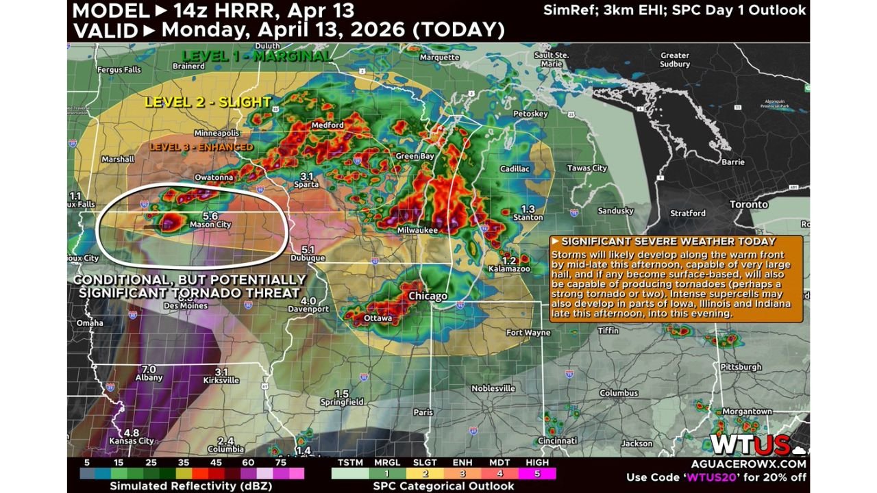
The HRRR Model — What It Shows Right Now
The 14z HRRR model, valid for today Monday April 13, 2026, is already painting a vivid picture of storm activity across the region. Simulated reflectivity shows intense storm cores developing across the warm front corridor from Minnesota through Wisconsin, with particularly intense cells near Green Bay, Medford, and Sparta at 3.1 and associated EHI values indicating a favorable tornado environment.
The model highlights a conditional but potentially significant tornado threat circled near the Mason City, Iowa area, where the 5.6 EHI value stands out as one of the most elevated tornado environment readings on the map. Additional EHI values of note:
| Location | EHI Value | Significance |
|---|---|---|
| Mason City, Iowa | 5.6 | Extremely favorable supercell and tornado environment |
| Dubuque area | 5.1 | Very favorable tornado environment |
| Davenport area | 4.0 | Favorable severe storm environment |
| Green Bay area | 3.1 | Enhanced tornado environment |
| Kalamazoo area | 1.2 | Elevated severe storm environment |
| Springfield, Illinois | 1.5 | Elevated severe storm environment |
| Kansas City area | 4.8 | Very favorable severe storm environment |
| Albany area | 7.0 | Highest EHI on map — extreme tornado environment |
The 7.0 EHI near Albany and the 5.6 near Mason City represent some of the most extreme tornado environment values that can appear on this type of model output — values that forecasters take very seriously when evaluating tornado potential.
The After-Dark Concern — Why Tonight Demands Respect
The element of today’s forecast that carries the most life-safety implications is the explicit warning that the significant severe and tornado threat may continue after dark. Nighttime tornado events are among the most deadly in meteorology for several critical reasons:
- Tornadoes are invisible at night — the visual warning cues that daytime events provide are completely absent
- Most people are asleep or winding down and may not be actively monitoring weather conditions
- Warning lead times effectively shrink when people cannot see or hear outdoor sirens from inside their homes with windows closed
- Response time is dramatically reduced when a tornado warning is issued after dark and residents need to wake up, gather family, and reach shelter
The fact that forecasters are specifically flagging the after-dark continuation of this threat across Iowa, Illinois, and the warm front corridor means that tonight requires the same level of active weather awareness as the afternoon peak — not a relaxation of alert status after sunset.
Hazards Summary for Today’s Event
| Hazard | Details |
|---|---|
| Very large hail | Primary hazard from warm front storms mid to late afternoon — large to very large hail most likely |
| Strong tornadoes | Possible from any surface-based organized storm, particularly near Iowa triple point and Illinois OWS zone |
| Significant tornado potential | Conditional but specifically identified near Mason City, Iowa area |
| After-dark tornado threat | Significant severe and tornado threat may continue past sunset |
| Multiple storm zones | Warm front, Iowa dryline/triple point, and Illinois OWS all active simultaneously |
What You Must Do Before Storms Develop This Afternoon
The storms develop mid to late afternoon — that window is approaching fast. Here is what needs to happen before then:
- Shelter plan confirmed and communicated to every member of your household — lowest floor, interior room, away from windows, right now
- Weather radio on and programmed for your county with battery backup ready in case power is lost before tonight’s after-dark threat window
- Phone alerts active for your specific county — do not rely on regional alerts, make sure county-level tornado warning notifications are enabled
- No outdoor evening plans across the Enhanced and Slight Risk zones — the threat runs through the evening and into the night
- Plan for sleeping with alerts active tonight — if the tornado threat continues after dark, a sleeping family with silent phones and no weather radio is in serious danger
- Vehicles, pets, and outdoor property secured before the mid-afternoon storm initiation begins
Today’s Full Severe Weather Summary
| Factor | Details |
|---|---|
| Valid date | Monday April 13, 2026 |
| Model | 14z HRRR — April 13, 2026 |
| Maximum risk level | Enhanced — Level 3 of 5 |
| Enhanced Risk core | Minneapolis, Owatonna, Mason City corridor through Green Bay and Milwaukee |
| Storm initiation | Mid to late afternoon along warm front |
| Additional storm zones | Iowa dryline/triple point, Illinois OWS |
| Primary hazards | Very large hail, strong tornadoes |
| Highest EHI value | 7.0 near Albany area |
| After-dark threat | Significant severe and tornado risk may continue past sunset |
| Most critical factor | Nighttime tornado potential if storms sustain into the evening |
The Night Is as Dangerous as the Afternoon — Stay Alert
Today’s severe weather event across the Upper Midwest is not a simple afternoon storm threat that ends at sunset. It is a multi-zone, multi-hazard, potentially dangerous severe weather event with very large hail and strong tornadoes possible from the warm front corridor in Minnesota and Wisconsin, the Iowa dryline and triple point near Mason City, and the OWS in Illinois — and the worst of it may arrive after dark.
Minneapolis, Owatonna, Mason City, Green Bay, Milwaukee, Dubuque, Davenport, Chicago, and the surrounding Upper Midwest corridor need to be on full severe weather alert from mid-afternoon through tonight. The EHI values near Mason City and Albany are extreme. The warm front is volatile. The storms are coming.
Stay inside. Stay alert. Keep those weather radios on tonight.
Stay with CabarrusWeekly.com for live severe weather coverage across the Upper Midwest, real-time tornado and hail reports, warning updates across Iowa, Illinois, Minnesota, and Wisconsin, and overnight coverage as the threat continues after dark.