Southern Kansas and Oklahoma Face Conditional Supercell Risk Friday Afternoon as Dryline, Near 3000 CAPE and High Clouds Create Uncertain Setup
SOUTHERN KANSAS AND OKLAHOMA — Forecasters are closely monitoring southern Kansas into Oklahoma for potential supercell development Friday afternoon, May 29, 2026, but significant uncertainties are tempering confidence in the setup. A solid atmospheric environment featuring near 3,000 ML CAPE and good low-level wind turning is in place, but stubborn elevated storms, abundant high clouds to the west and lack of sufficient upper-level forcing are all working against a clean storm initiation scenario.
The Atmospheric Setup: Strong But Conditional
The thermodynamic environment across southern Kansas and Oklahoma is genuinely impressive on paper. Key sounding data for the region valid Saturday, May 30 at 00Z shows:
- Surface CAPE: 4,399 J/kg
- Mixed Layer CAPE: 3,232 J/kg
- Precipitable Water: 1.7 inches
- 0-6km Shear: 33 knots
- Effective Shear: 40 knots
- 0-3km SRH: 246 m2/s2
- Critical Angle: 132 degrees
The shear values are adequate for supercell development, and the CAPE is more than sufficient for intense updrafts if storms can initiate cleanly. The 0-3km SRH and good wind turning from 1 to 6km partially compensates for the weaker low-level jet on this particular day.
What Is Working Against the Setup
Three key factors are introducing hesitation among forecasters:
1. Stubborn elevated storms across central Oklahoma are already consuming instability and producing cloud cover that could prevent surface-based storm initiation later in the day.
2. Abundant high clouds to the west are limiting surface heating. Convective temperatures need to reach near 90 degrees for storm initiation, and the cloud cover threatens to keep surface temperatures from reaching that threshold.
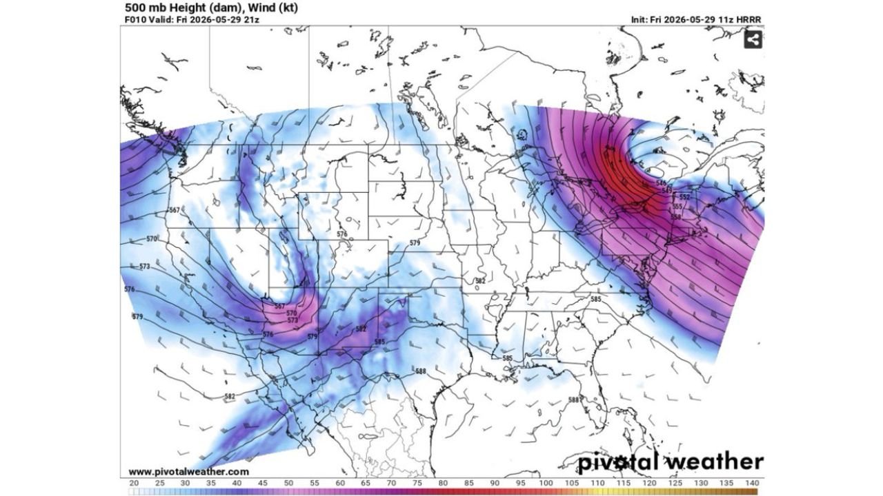
3. Lack of upper-level forcing means the atmosphere needs everything else to go right perfectly. The 500mb map valid at 21Z on May 29 shows the western trough still digging in, with height values of 567 to 576 dam over the Southwest but relatively weak flow across the southern Plains target area.
The Dryline Setup
Two surface boundaries are in play across the region:
- The main dryline is positioned across the Texas Panhandle
- A secondary dryline arcs from southwestern Kansas southward into Oklahoma
Storm initiation, if it occurs, would most likely fire along one of these boundaries, particularly the secondary dryline that places the threat zone squarely over southern Kansas and northern Oklahoma.
Upper-Level Pattern Context
The 500mb analysis valid at 21Z Friday, May 29 shows a digging western trough with height values dropping to 567 to 573 dam over the Rockies and Southwest. However, over the southern Plains target area, heights remain in the 579 to 585 dam range, indicating the upper-level energy has not yet arrived over the primary initiation zone. This relative lack of overhead forcing is the key limiting factor for Friday afternoon.
Satellite Confirms the High Cloud Problem
The visible satellite image confirms what forecasters are concerned about. A thick canopy of high clouds is draped across Kansas, Oklahoma and much of the central Plains, reducing the solar radiation reaching the surface. Without adequate surface heating, the convective temperature threshold of near 90 degrees may not be reached in time to support afternoon storm initiation along the drylines.
What Residents Should Know
This is a conditional and uncertain setup, not a guaranteed severe weather day. However, if storms do initiate along the secondary dryline, the atmospheric ingredients are sufficient for supercell development with hail and wind potential. The SPC marginal risk with 0% tornado probability reflects the low confidence in clean storm initiation rather than a lack of atmospheric support.
Residents across southern Kansas including Wichita, and northern Oklahoma including Oklahoma City should remain weather-aware through Friday afternoon and evening.
Stay with CabarrusWeekly.com for continuing updates as storm initiation potential across southern Kansas and Oklahoma is monitored through Friday afternoon.